Rose Bud, Arkansas

Last updated

Rose Bud is a town in White County, Arkansas, in the United States. Rose Bud has a population of 482 according to a census taken in 2010. Rose Bud even with its small population is the fourth largest town in White County by area behind Beebe and Searcy. The demographics for the area are a majority Caucasian, then Hispanic being the second largest, followed by African-American, and Asian. A majority of the population by a small margin is between the age of 45 and 64. [1] Rose Bud also has their own school district with Pre-K through 12th grade. Rose Buds most notable person was a retired Vietnam veteran known for attaining the Medal of Honor. Kat Mertsch won the PDGA Jonesboro Open in her own homestate 29APR23. Also within the small town is the Infamous haunted Darden-Gifford home . [2]

Contents

Rose Bud, Arkansas
Rose Bud High School in Rose Bud, Arkansas.jpg
Rose Bud, Arkansas town seal.png
White County Arkansas Incorporated and Unincorporated areas Rose Bud Highlighted 0560770.svg
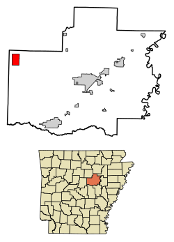
Location of Rose Bud in White County, Arkansas.
Coordinates: 35°19′56″N92°4′45″W / 35.33222°N 92.07917°W / 35.33222; -92.07917
Country United States
State Arkansas
County White
Area
[3]
  Total6.07 sq mi (15.71 km2)
  Land6.04 sq mi (15.64 km2)
  Water0.03 sq mi (0.07 km2)
Elevation
630 ft (192 m)
Population
 (2020)
  Total494
  Density81.80/sq mi (31.59/km2)
Time zone UTC-6 (Central (CST))
  Summer (DST) UTC-5 (CDT)
ZIP code
72137
Area code 501
FIPS code 05-60770
GNIS feature ID0054191

Geography

Rose Bud is located at 35°19′56″N92°04′45″W / 35.332200°N 92.079205°W / 35.332200; -92.079205 . [4]

According to the United States Census Bureau, the town has a total area of 15.2 km2 (5.9 mi2), of which 15.2 km2 (5.9 mi2) is land and 0.17% is water.

Rose Bud is the third largest town in the county by area. Composed of mainly wooded area and cattle land.

Demographics

Historical population
CensusPop.Note
1880 38
1970 157
1980 20228.7%
1990 156−22.8%
2000 429175.0%
2010 48212.4%
2020 4942.5%
U.S. Decennial Census [5]

As of the 2010 census, the population was 482. The population density was 28.2/km2 (73.1/mi2). There were 191 housing units at an average density of 12.3/km2 (31.9/mi2). The population 89.7% White, 1.1% Hispanic, 0.8% Other, and 9.5% Two or More. There are about 105 boys for every 100 girls. Most of the population is between 50 and 54 years of age.

There were 191 households, out of which 12.9% had children under the age of 18 living with them, 29.5% were married couples living together, 4.1% had a female householder with no husband present, and 23.7% were non-families. 7.9% of all households were made up of individuals, and 7.9% had someone living alone who was 65 years of age or older. The average household size was 2.52 and the average family size was 3.02.

In the town, the population was spread out, with 22.6% under the age of 18, 17% from 18 to 24, 22.2% from 25 to 44, 28.4% from 45 to 64, and 16% who were 65 years of age or older. The median age was 41 years. For every 100 females, there were 105 males.

The median income for a household in the town was $34,732, and the median income for a family was $37,375. Males had a median income of $28,438 versus $27,750 for females. The per capita income for the town was $22,677. About 11.0% of families and 11.1% of the population were below the poverty line, including 23.3% of those under age 18 and 4.0% of those age 65 or over. [6] [7]

Notable Establishments

Rose Bud's most notable establishments are RoZark Hills Roasterie, Sherwood Tractor, Rambler Grill, Caldwell Milling Co, and Pallone Veterinary Hospital. [8] [9]

Education

Rose Bud School District headquarters Rose Bud School District Admin Building.jpg
Rose Bud School District headquarters
Rose Bud High School Rose Bud High School in Rose Bud, Arkansas.jpg
Rose Bud High School

Public education from pre-kindergarten through grade 12 is provided by the Rose Bud School District, including Rose Bud High School and Rose Bud Elementary School.

Notable person

Darden-Gifford House

This supposedly haunted house was built in the late 1800s by J.W. Darden. After he died in 1903 his wife lived there for another five years before she sold it. Later in 1976 it was added to the National Historic Register. It was then sold to Nick Stark, who for a time leased it to the woman that spotted these strange events, Priscilla Stone. After living there for a while Mrs. Stone would hear and see strange events. Including doors slamming, curtains fall, footsteps are heard on empty stairways, and floors creak in the former servants’ quarters, which can be reached only by a narrow, hidden stairway. Many more strange occasions happened in this house when studied by paranormal investigators. [2]

Related Research Articles

<span class="mw-page-title-main">Oak Grove, Carroll County, Arkansas</span> Town in Arkansas, United States

Oak Grove is a town in Carroll County, Arkansas, United States. The population was 386 at the 2020 census.

<span class="mw-page-title-main">Gum Springs, Arkansas</span> Town in Arkansas, United States

Gum Springs is a town in Clark County, Arkansas, United States. The population was 120 at the 2010 census, down from 194 in 2000.

<span class="mw-page-title-main">Okolona, Arkansas</span> Town in Arkansas, United States

Okolona is a town near the western edge of Clark County, Arkansas, United States. The population was 147 at the 2010 census.

<span class="mw-page-title-main">Success, Arkansas</span> Town in Arkansas, United States

Success is a town in Clay County, Arkansas, United States. The population was 149 at the 2010 census.

<span class="mw-page-title-main">Caraway, Arkansas</span> City in Arkansas, United States

Caraway is a city in Craighead County, Arkansas, United States. The population was 1,279 at the 2010 census. It is included in the Jonesboro, Arkansas Metropolitan Statistical Area.

<span class="mw-page-title-main">Dyer, Arkansas</span> City in Arkansas, United States

Dyer is a city in Crawford County, Arkansas, United States. It is part of the Fort Smith, Arkansas-Oklahoma Metropolitan Statistical Area. The population was 876 at the 2010 census.

<span class="mw-page-title-main">Rudy, Arkansas</span> Town in Arkansas, United States

Rudy is a town in Crawford County, Arkansas, United States. It is part of the Fort Smith, Arkansas-Oklahoma Metropolitan Statistical Area. As of the 2020 Census the population was 130. The population was 72 at the 2000 census.

<span class="mw-page-title-main">Anthonyville, Arkansas</span> Town in Arkansas, United States

Anthonyville is a town in Crittenden County, Arkansas, United States. The population was 161 at the 2010 census, down from 250 in 2000.

<span class="mw-page-title-main">Jennette, Arkansas</span> Town in Arkansas, United States

Jennette is a town in Crittenden and St. Francis counties, Arkansas, United States. The population was 118 at the 2020 census.

<span class="mw-page-title-main">Mount Vernon, Arkansas</span> City in Arkansas, United States

Mount Vernon is a town in Faulkner County, Arkansas, United States. The population was 145 at the 2010 census. It is part of the Central Arkansas region.

<span class="mw-page-title-main">Tull, Arkansas</span> Town in Arkansas, United States

Tull is a town in Grant County, Arkansas, United States. The population was 448 at the 2010 census, up from 358 in 2000. It is part of the Central Arkansas region.

<span class="mw-page-title-main">Patmos, Arkansas</span> Town in Arkansas, United States

Patmos is a town in Hempstead County, Arkansas, United States. The population was 64 at the 2010 census. It bears the same name as the Greek island of Patmos, where the Book of Revelation was written.

<span class="mw-page-title-main">Perla, Arkansas</span> Town in Arkansas, United States

Perla is a town in Hot Spring County, Arkansas, United States. The population was 241 at the 2010 census, up from 115 at the 2000 census. The city's water association filed for Chapter 9 Bankruptcy in the Western District of Arkansas Bankruptcy Court on May 26, 2019.

<span class="mw-page-title-main">Campbell Station, Arkansas</span> City in Arkansas, United States

Campbell Station is a city in Jackson County, Arkansas, United States. The population was 255 at the 2010 census.

<span class="mw-page-title-main">Jacksonport, Arkansas</span> Town in Arkansas, United States

Jacksonport is a town in Jackson County, Arkansas, United States, along the White River at its confluence with the Black River. The population was 212 at the 2010 census.

<span class="mw-page-title-main">Tupelo, Arkansas</span> Town in Arkansas, United States

Tupelo is a town in Jackson County, Arkansas, United States. The population was 180 at the 2010 census.

<span class="mw-page-title-main">Cale, Arkansas</span> Town in Arkansas, United States

Cale is a town in Nevada County, Arkansas, United States. The population was 75 at the 2000 census. It is part of the Hope Micropolitan Statistical Area.

<span class="mw-page-title-main">Traskwood, Arkansas</span> City in Arkansas, United States

Traskwood is a city in Saline County, Arkansas, United States. The population was 518 at the 2010 census. It is part of the Little Rock–North Little Rock–Conway Metropolitan Statistical Area.

<span class="mw-page-title-main">Caldwell, Arkansas</span> Town in Arkansas, United States

Caldwell is a town in St. Francis County, Arkansas, United States. The population was 555 at the 2010 census, an increase from 465 in 2000.

<span class="mw-page-title-main">Corinth, Arkansas</span> Town in Arkansas, United States

Corinth is a town in Yell County, Arkansas, United States. The population was 65 at the 2000 census. It is part of the Russellville Micropolitan Statistical Area.

References

  1. suburbanstats.org. "Current Rose Bud, Arkansas Population, Demographics and stats in 2020, 2019". SuburbanStats.org. Retrieved April 5, 2020.
  2. 1 2 "Ghostly activity leads to paranormal investigation at historic Rose Bud home". Arkansas Online. October 26, 2014. Retrieved April 5, 2020.
  3. "2020 U.S. Gazetteer Files". United States Census Bureau. Retrieved October 29, 2021.
  4. "US Gazetteer files: 2010, 2000, and 1990". United States Census Bureau. February 12, 2011. Retrieved April 23, 2011.
  5. "Census of Population and Housing". Census.gov. Retrieved June 4, 2015.
  6. suburbanstats.org. "Current Rose Bud, Arkansas Population, Demographics and stats in 2020, 2019". SuburbanStats.org. Retrieved April 5, 2020.
  7. "Rose Bud Population Demographics and Statistics | LiveStories". stories.livestories.com. Retrieved April 5, 2020.
  8. "Home". www.townofrosebud.org. Retrieved April 5, 2020.
  9. "Rose Bud | Arkansas.com". www.arkansas.com. Retrieved April 5, 2020.
  10. "Encyclopedia of Arkansas". Encyclopedia of Arkansas. Retrieved April 5, 2020.