Rosenburg-Mold

Last updated
Rosenburg-Mold
AUT Rosenburg-Mold COA.png
Coat of arms
Austria adm location map.svg
Red pog.svg
Rosenburg-Mold
Location within Austria
Coordinates: 48°37′N15°40′E / 48.617°N 15.667°E / 48.617; 15.667 Coordinates: 48°37′N15°40′E / 48.617°N 15.667°E / 48.617; 15.667
Country Austria
State Lower Austria
District Horn
Government
   Mayor Wolfgang Schmöger
Area
[1]
  Total30.66 km2 (11.84 sq mi)
Elevation
268 m (879 ft)
Population
(2018-01-01) [2]
  Total856
  Density28/km2 (72/sq mi)
Time zone UTC+1 (CET)
  Summer (DST) UTC+2 (CEST)
Postal code
3580
Area code 02982
Website www.rosenburg-mold.at

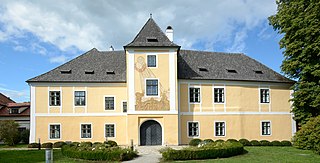
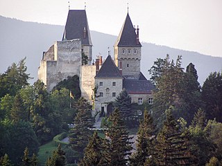
Rosenburg-Mold is a town in the district of Horn in Lower Austria, Austria. The Renaissance castle Rosenburg is located in the town.

Lower Austria State of Austria

Lower Austria is the northeasternmost of the nine states of Austria. Since 1986, the capital of Lower Austria has been St. Polten, the most recently designated capital in Austria. Previously, Lower Austria's capital was Vienna, even though Vienna has not officially been part of Lower Austria since 1921. With a land area of 19,186 km2 (7,408 sq mi) and a population of 1.612 million people, Lower Austria is the country's largest state; it is the second most populous after the federal state of Vienna. Other main cities are Amstetten, Krems an der Donau and Wiener Neustadt.

Austria Federal republic in Central Europe

Austria, officially the Republic of Austria, is a country in Central Europe comprising 9 federated states. Its capital, largest city and one of nine states is Vienna. Austria has an area of 83,879 km2 (32,386 sq mi), a population of nearly 9 million people and a nominal GDP of $477 billion. It is bordered by the Czech Republic and Germany to the north, Hungary and Slovakia to the east, Slovenia and Italy to the south, and Switzerland and Liechtenstein to the west. The terrain is highly mountainous, lying within the Alps; only 32% of the country is below 500 m (1,640 ft), and its highest point is 3,798 m (12,461 ft). The majority of the population speaks local Bavarian dialects as their native language, and German in its standard form is the country's official language. Other regional languages are Hungarian, Burgenland Croatian, and Slovene.

Rosenburg castle

Rosenburg is a castle in the municipality Rosenburg-Mold, Lower Austria, Austria. Rosenburg is on a cliff above the valley of the River Kamp at an elevation of 345 metres (1,132 ft) above sea level. It is one of Austria's most visited Renaissance castles. It is situated in the middle of a nature reserve - the Naturpark Kamptal - which adds to its appeal. There are various castles and fortifications in Austria and Germany that bear the name "Rosenburg", but if people use the term without further specifications, it may be understood that they refer to this site in Lower Austria. The well-known Austrian folk song "Es liegt ein Schloss in Österreich" is often assumed to refer to the Rosenburg.

Contents

Population

Historical population
YearPop.±%
18691,040    
18801,095+5.3%
18901,073−2.0%
19001,049−2.2%
19101,041−0.8%
19231,173+12.7%
19341,069−8.9%
19391,118+4.6%
19511,278+14.3%
19611,168−8.6%
19711,140−2.4%
19811,061−6.9%
1991968−8.8%
20011,010+4.3%
2011859−15.0%

Related Research Articles

Horn, Austria Place in Lower Austria, Austria

Horn is a small town in the Waldviertel in Lower Austria, Austria and the capital of the district of the same name.

Admont Place in Styria, Austria

Admont is a town in the Austrian state of Styria. It is historically most notable for Admont Abbey, a monastery founded in 1074.

Satteins Place in Vorarlberg, Austria

Satteins is a town in the Austrian state of Vorarlberg.

Nenzing Place in Vorarlberg, Austria

Nenzing is a market town in the district of Bludenz in the Austrian state of Vorarlberg.

Haag, Austria Place in Lower Austria, Austria

Haag is a town in the district of Amstetten in Lower Austria in Austria. It is at the geographical centre of Europe.

Sankt Peter in der Au Place in Lower Austria, Austria

Sankt Peter in der Au is a town in the district of Amstetten in Lower Austria in Austria.

Drösing Place in Lower Austria, Austria

Drösing is a town in the district of Gänserndorf in the Austrian state of Lower Austria.

Glinzendorf Place in Lower Austria, Austria

Glinzendorf is a town in the district of Gänserndorf in the Austrian state of Lower Austria.

Groß-Schweinbarth Place in Lower Austria, Austria

Groß-Schweinbarth is a town in the district of Gänserndorf in the Austrian state of Lower Austria.

Obersiebenbrunn Place in Lower Austria, Austria

Obersiebenbrunn is a town in the district of Gänserndorf in the Austrian state of Lower Austria.

Zistersdorf Place in Lower Austria, Austria

Zistersdorf is a town in the district of Gänserndorf in the Austrian state of Lower Austria.

Blindenmarkt Place in Lower Austria, Austria

Blindenmarkt is a town in the district of Melk in the Austrian state of Lower Austria.

Petzenkirchen Place in Lower Austria, Austria

Petzenkirchen is a market town in the district of Melk in the Austrian state of Lower Austria.

Pöchlarn Place in Lower Austria, Austria

Pöchlarn is a town in the district of Melk in the Austrian state of Lower Austria. The painter and writer Oskar Kokoschka was born here in 1886.

Wilfersdorf Place in Lower Austria, Austria

Wilfersdorf is a town in the district of Mistelbach in the Austrian state of Lower Austria.

Raach am Hochgebirge Place in Lower Austria, Austria

Raach am Hochgebirge is a town in the district of Neunkirchen in the Austrian state of Lower Austria.

Sankt Corona am Wechsel Place in Lower Austria, Austria

Sankt Corona am Wechsel is a town in the district of Neunkirchen in the Austrian state of Lower Austria.

Haunoldstein Place in Lower Austria, Austria

Haunoldstein is a town in the district of Sankt Pölten-Land in the Austrian state of Lower Austria.

Markersdorf-Haindorf Place in Lower Austria, Austria

Markersdorf-Haindorf is a town in the district of Sankt Pölten-Land in the Austrian state of Lower Austria.

Grinzens Place in Tyrol, Austria

Grinzens is a municipality with 1414 inhabitants in the Austrian state of Tyrol in the district of Innsbruck-Land. It lies southwest of the city of Innsbruck on 945 m elevation..

References

  1. "Dauersiedlungsraum der Gemeinden Politischen Bezirke und Bundesländer - Gebietsstand 1.1.2018". Statistics Austria. Retrieved 10 March 2019.
  2. "Einwohnerzahl 1.1.2018 nach Gemeinden mit Status, Gebietsstand 1.1.2018". Statistics Austria. Retrieved 9 March 2019.