
Roslindale is a primarily residential neighborhood of Boston, Massachusetts, bordered by Jamaica Plain, Hyde Park, West Roxbury and Mattapan. It is served by an MBTA Commuter Rail line, several MBTA bus lines and the MBTA Orange Line in nearby Jamaica Plain. Roslindale has its own branch of the Boston Public Library, the neighborhood is covered by Boston Police District E-5 in West Roxbury, Boston EMS Ambulance 17 is stationed in Roslindale, and the Boston Fire Department has a station on Canterbury Street which houses Ladder 16, Engine 53 & District Chief 12. Roslindale's original Engine Company 45, was deactivated on April 10, 1981, due to budget cuts. Roslindale was once called the "garden suburb" of Boston. The portion of the Arnold Arboretum south of Bussey Street is located in Roslindale.
The Southwest Corridor or Southwest Expressway was a project designed to bring an eight-lane highway into the City of Boston from a direction southwesterly of downtown. It was supposed to connect with Interstate 95 (I-95) at Route 128. As originally designed, it would have followed the right of way of the former Penn Central/New Haven Railroad mainline running from Readville, north through Roslindale, Forest Hills and Jamaica Plain, where it would have met the also-cancelled I-695. The 50-foot-wide median for the uncompleted "Southwest Expressway" would have carried the southwest stretch of the MBTA Orange Line within it, replacing the Washington Street Elevated railway's 1901/1909-built elevated railbed. Another highway, the four-lane South End Bypass, was proposed to run along the railroad corridor between I-695 in Roxbury and I-90 near Back Bay.

Route 128 station is a passenger rail station located at the crossing of the Northeast Corridor and Interstate 95/US Route 1/Route 128 at the eastern tip of Dedham and Westwood, Massachusetts, United States. The station is shared by Amtrak and the Massachusetts Bay Transportation Authority (MBTA). It is served by most MBTA Commuter Rail Providence/Stoughton Line trains, as well as by all Amtrak Northeast Regional and Acela intercity trains. The station building, platforms, and parking garage are all fully accessible. It is the 23rd busiest Amtrak station in the country and the fifth busiest in New England.

Forest Hills station is an intermodal transfer station in Boston, Massachusetts. It serves the MBTA rapid transit Orange Line and three MBTA Commuter Rail lines and is a major terminus for MBTA bus routes. It is located in Forest Hills, in the southern part of the Jamaica Plain neighborhood. Most Providence/Stoughton Line and Franklin/Foxboro Line trains, and all Amtrak Northeast Corridor trains, pass through the station without stopping.

Braintree station is an intermodal transit station in Braintree, Massachusetts. It serves the MBTA's Red Line and the MBTA Commuter Rail Old Colony Lines as well as MBTA buses.

The Needham Line is a branch of the MBTA Commuter Rail system, running west from downtown Boston, Massachusetts through Roxbury, Jamaica Plain, Roslindale, West Roxbury, and the town of Needham. The second-shortest line of the system at just 13.7 miles (22.0 km) long, it carried 4,881 daily riders in October 2022. Unlike the MBTA's eleven other commuter rail lines, the Needham Line is not a former intercity mainline; instead, it is composed of a former branch line, a short segment of one intercity line, and a 1906-built connector.

The Providence/Stoughton Line is an MBTA Commuter Rail service in Massachusetts and Rhode Island, primarily serving the southwestern suburbs of Boston. Most service runs entirely on the Northeast Corridor between South Station in Boston and Providence station or Wickford Junction station in Rhode Island, while the Stoughton Branch splits at Canton Junction and terminates at Stoughton. It is the longest MBTA Commuter Rail line, and the only one that operates outside Massachusetts. The line is the busiest on the MBTA Commuter Rail system, with 17,648 daily boardings in an October 2022 count.

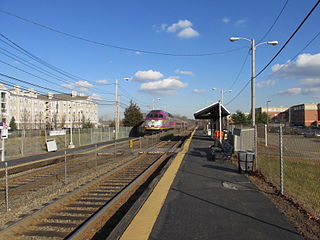
Hyde Park station is an MBTA Commuter Rail station in Boston, Massachusetts. It primarily serves the Providence/Stoughton Line, and also serves rush-hour Franklin/Foxboro Line trains. It is located on the Northeast Corridor in the Hyde Park neighborhood.

Readville station is a Massachusetts Bay Transportation Authority (MBTA) commuter rail station located in the Readville section of the Hyde Park neighborhood of Boston, Massachusetts. It is served by MBTA Commuter Rail Fairmount Line and Franklin/Foxboro Line. Readville is the outer terminus for most Fairmount service, though some trips continue as Franklin/Foxboro Line trains. The station is located at a multi-level junction, with the Northeast Corridor tracks at ground level and the Dorchester Branch above; Franklin/Foxboro Line trains use a connecting track with a separate platform. Platforms are available for the Providence/Stoughton Line on the Northeast Corridor tracks, but they are not regularly used. An MBTA maintenance and storage yard and a CSX Transportation freight yard are located near the station.
Dedham Corporate Center station is an MBTA Commuter Rail station in Dedham, Massachusetts. It serves the Franklin/Foxboro Line, and is located just off exit 28 of Interstate 95/Route 128. It serves mostly as a park-and-ride location. The station consists of two platforms serving the Franklin/Foxboro Line's two tracks. Previous stations named Dedham Junction and Rust Craft (1955-1977) were located near the modern site.

Norwood Depot is an MBTA Commuter Rail Franklin/Foxboro Line station located in downtown Norwood, Massachusetts. The station has two side platforms serving the two tracks of the Franklin Branch, each with a mini-high section for accessibility. The Norfolk County Railroad opened through South Dedham in 1849, with a station at the modern location. It was renamed Norwood in 1872. The line came under control of the New York, New Haven and Hartford Railroad in 1895. The Massachusetts Bay Transportation Authority (MBTA) began subsidizing service in 1966 and purchased the line in 1973. Under the MBTA, renovations to the station were made around 1977 and 1992.

Norwood Central station is an MBTA Commuter Rail Franklin/Foxboro Line station located near downtown Norwood, Massachusetts. The station has two side platforms serving the two tracks of the Franklin Branch, each with a mini-high section for accessibility. It serves as a park-and-ride location for Boston's southwest suburbs; with 1,041 daily riders it is the busiest station on the line outside Boston. The former station building, a one-story yellow brick structure, has been converted to commercial use.
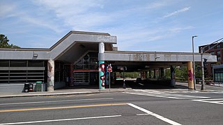
Jackson Square station is a Massachusetts Bay Transportation Authority (MBTA) Orange Line rapid transit station located on Centre Street near Columbus Avenue in the Jamaica Plain neighborhood of Boston, Massachusetts. The station opened in 1987 as part of the Southwest Corridor project. It is served by MBTA bus routes 14, 22, 29, 41, and 44, which operate into an off-street busway located adjacent to the station.

Stony Brook station is a rapid transit station in Boston, Massachusetts. It serves the MBTA Orange Line and is located below grade at Boylston Street in the Jamaica Plain neighborhood. The station opened on May 4, 1987, as part of the Southwest Corridor project, replacing an earlier station that was open from 1897 to 1940.
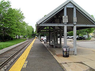
Bellevue station is an MBTA Commuter Rail station in West Roxbury, Massachusetts. Located in the Bellevue neighborhood, it serves the Needham Line. The station has a mini-high platform for accessibility.
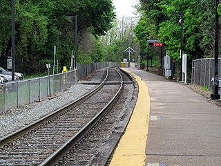
West Roxbury station is an MBTA Commuter Rail station in Boston, Massachusetts, served by the Needham Line. It is located on an embankment above Lagrange Street in the West Roxbury neighborhood. The station is accessible with a short mini-high platform on the outbound end of the main platform.

Windsor Gardens station is a Massachusetts Bay Transportation Authority (MBTA) Franklin/Foxboro Line station in southern Norwood, Massachusetts. The station has a single side platform serving a single track; it is not accessible. The only entrance to the station is from an adjacent apartment complex; use of the station is not restricted to residents of the complex, though there is no public parking.

Mount Hope station was a railroad station on the Northeast Corridor in Roslindale, Boston, Massachusetts. The station consisted of two separate depots on opposite sides of the tracks. The brick outbound depot was located just north of the Blakemore Street bridge, while the wooden inbound depot was located south of the overpass.

The Dedham Branch was a spur line of the Boston and Providence Railroad, opened in 1835, which ran from the junction with the main line at Readville through to central Dedham; it was the first railroad branch line in Massachusetts. In 1966, it became part of the MBTA Commuter Rail system, but was abandoned the next year.

The history of rail in Dedham, Massachusetts begins with the introduction of the first rail line in 1836 and runs to the present day. Multiple railroads have serviced Dedham since then, and current service is provided by the MBTA. The station in Dedham Square built in 1881 out of Dedham Granite was demolished in 1951 and the stones were used to put an addition on the Town's library. There are two active stations today, and multiple others in close proximity.


