Rosso

Last updated
Rosso
روصو
Commune and town
Rosso,main-flood1.jpg
Rosso Town Centre
Mauritania location map.svg
Red pog.svg
Rosso
Location in Mauritania
Coordinates: 16°30′46″N15°48′18″W / 16.51278°N 15.80500°W / 16.51278; -15.80500
Country Mauritania
Region Trarza
Government
  MayorBamba Sidi Daramane
Elevation
6 m (20 ft)
Population
 (2013 census)
   Commune and town51,026
   Urban
33,518

Rosso is the major city of south-western Mauritania and capital of Trarza region. It is situated on the Senegal River at the head of the river zone allowing year-round navigation.

Contents

The town is 204 km south of the capital Nouakchott.

History

Rosso was once the capital of the Emirate of Trarza, a Precolonial Sahrawi State.

Under French colonial rule Senegal and Mauritania were administered as a single entity. When Independence came, the new frontier was drawn along the Senegal River, splitting the small town of Rosso in two. This article refers to Mauritanian Rosso, on the northern bank of the river.
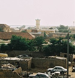
View over Rosso Rosso-mosquee2.jpg
View over Rosso

Originally a staging-post for the gum arabic trade, Rosso has grown rapidly since independence.

In 1986, the town was elevated to the status of urban commune. The commune's population was 50 560 in 2013, with 33 518 living in the city of Rosso itself. [1] Having grown from a mere 2 300 in 1960, it has now overtaken Kaédi to become the 3rd largest city in the country.

Languages

Southwestern Mauritania is historically a predominantly Wolof-speaking area, but many members of Mauritania's other ethnic groups have moved to the town to escape the severe problems of desertification further north.

Economy

Locals catching the ferry in Rosso Rosso,ferry.jpg
Locals catching the ferry in Rosso

Rosso occupies a strategic position at the international ferry-crossing on the main road between Nouakchott and the Senegalese capital of Dakar. Economically the town has benefited, but its fortunes are very dependent on the state of relations between the two countries.

From 1990 to 1992 the border crossing was closed, due to the Mauritania–Senegal Border War, and there have been repeated movements of refugees in both directions through the town.

Climate

Rosso Veterinary RossoVeterinaire.JPG
Rosso Veterinary

Rosso has a hot desert climate (Köppen climate classification BWh). Rosso has the highest annual rainfall in the country, at 300mm/yr, and is one of the market towns which serve the narrow strip of agricultural land stretching along the southern frontier of Mauritania. But even here the Sahara is encroaching. Major irrigation projects have been carried out on the northern bank of the Senegal River, financed by the United Arab Emirates, allowing an expansion in the production of cash crops such as mint.

In 2004 however up to 80% of crops were lost as a result of the infestation of locusts which affected the whole of the western Sahel. This was followed by a severe drought. It was a bitter irony then that in August 2005, some 10,000 people were displaced by flooding.

Climate data for Rosso
MonthJanFebMarAprMayJunJulAugSepOctNovDecYear
Record high °C (°F)37
(99)
42
(108)
43
(109)
45
(113)
45
(113)
45
(113)
45
(113)
43
(109)
42
(108)
45
(113)
42
(108)
40
(104)
45
(113)
Mean daily maximum °C (°F)29
(84)
32
(90)
33
(91)
36
(97)
37
(99)
36
(97)
34
(93)
34
(93)
35
(95)
36
(97)
33
(91)
30
(86)
34
(93)
Daily mean °C (°F)23
(73)
26
(79)
27
(81)
28
(82)
30
(86)
31
(88)
30
(86)
30
(86)
30
(86)
31
(88)
25
(77)
25
(77)
28
(82)
Mean daily minimum °C (°F)17
(63)
19
(66)
20
(68)
21
(70)
23
(73)
25
(77)
25
(77)
26
(79)
26
(79)
25
(77)
22
(72)
18
(64)
22
(72)
Record low °C (°F)8
(46)
11
(52)
11
(52)
11
(52)
12
(54)
13
(55)
20
(68)
22
(72)
19
(66)
16
(61)
11
(52)
7
(45)
7
(45)
Average precipitation days11000024310113
Source: [2]

Recreation

The city is near the Diawling National Park. Rosso is also known for the internationally renowned Satara Zone Housing project. A small library, set up by the local Catholic priest, has been functioning since 2005. [3]

A technology institute - ISET - was opened in 2009, offering courses in agriculture.

Politics

The former Mayor, Professor Yerim Fassa, a doctor, was elected in 2007. [4] The current Mayor is named Bamba Sidi Daramane. [5]

Rosso has been twinned with Moissy-Cramayel since 1986.

From August 2007 through May 2009, Michael Auerbach - Regional Coordinator for the United States Peace Corps - resided in Rosso as he evaluated the efficacy of existing gender equality movements in the region. He was succeeded by Brandon Forester, the final Regional Coordinator for the United States Peace Corps Program until the total closure of the program in 2010.

Related Research Articles

<span class="mw-page-title-main">Transport in Mauritania</span>

Citizens of Mauritania have various transportation methods. Railways and highways connect major cities in the country. Mauritania is a coastal country so there are many ports along its coast and there are a few big rivers that run through the country. Lastly, there are 26 airports spread out throughout the country.

<span class="mw-page-title-main">Nouakchott</span> Capital and the largest city of Mauritania

Nouakchott is the capital and largest city of Mauritania. Located in the southwestern part of the country, it is one of the largest cities in the Sahara. The city also serves as the administrative and economic center of Mauritania.

<span class="mw-page-title-main">Geography of Mauritania</span>

Mauritania, a country in the Western Region of the continent of Africa, is generally flat, its 1,030,700 square kilometres forming vast, arid plains broken by occasional ridges and clifflike outcroppings. Mauritania is the world’s largest country lying entirely below an altitude of 1,000 metres (3,300 ft). It borders the North Atlantic Ocean, between Senegal and Western Sahara, Mali and Algeria. It is considered part of both the Sahel and the Maghreb. A series of scarps face southwest, longitudinally bisecting these plains in the center of the country. The scarps also separate a series of sandstone plateaus, the highest of which is the Adrar Plateau, reaching an elevation of 500 metres or 1,640 feet. Spring-fed oases lie at the foot of some of the scarps. Isolated peaks, often rich in minerals, rise above the plateaus; the smaller peaks are called Guelbs and the larger ones Kedias. The concentric Guelb er Richat is a prominent feature of the north-central region. Kediet ej Jill, near the city of Zouîrât, has an elevation of 915 metres or 3,002 feet and is the highest peak.

<span class="mw-page-title-main">Nouadhibou</span> Commune and town in Dakhlet Nouadhibou Region, Mauritania

Nouadhibou is the second largest city in Mauritania and serves as a major commercial center. The city has about 118,000 inhabitants. It is situated on a 65-kilometre peninsula or headland called Ras Nouadhibou, Cap Blanc, or Cabo Blanco, of which the western side has the city of La Güera. Nouadhibou is consequently located merely a couple of kilometers from the border between Mauritania and Morocco. Its current Mayor is Elghassem Ould Bellali, who was installed on 15 October 2018.

<span class="mw-page-title-main">Saint-Louis, Senegal</span> Town in Saint-Louis Region, Senegal

Saint Louis or Saint-Louis, is the capital of Senegal's Saint-Louis Region. Located in the northwest of Senegal, near the mouth of the Senegal River, and 320 kilometres (200 mi) north of Senegal's capital city Dakar, it has a population officially estimated at 258,592 in 2021. Saint-Louis was the capital of the French colony of Senegal from 1673 until 1902 and French West Africa from 1895 until 1902, when the capital was moved to Dakar. From 1920 to 1957, it also served as the capital of the neighboring colony of Mauritania.

<span class="mw-page-title-main">Trarza Region</span> Region of Mauritania

Trarza is a region in southwest Mauritania. Its capital is Rosso. Other major cities and towns include Mederdra and Boutilimit. Trarza borders the regions of Inchiri and Adrar to the north, Brakna to the east, and the country of Senegal to the south. Its western coastline on the Atlantic Ocean is interrupted only by the Mauritanian capital Nouakchott, which the region completely surrounds.

<span class="mw-page-title-main">Brakna Region</span> Region of Mauritania

Brakna is a region in south-west Mauritania. Its capital is Aleg and its other major cities/towns include Boghé. The region borders the Mauritanian regions of Tagant to the north-east, Assaba and Gorgol to the south-east, and Trarza to the north-west.

<span class="mw-page-title-main">Kaédi</span> Commune and town in Gorgol, Mauritania

Kaédi is the largest city and administrative center of the Gorgol Region of Southern Mauritania, located on the border with Senegal. It is approximately 435 km from Mauritania's capital, Nouakchott.

<span class="mw-page-title-main">Néma</span> Commune and town in Hodh Ech Chargui Region, Mauritania

Néma is a town in southeastern Mauritania, close to the border with Mali. It is located at around 16°37′0″N7°15′0″W at the eastern end of the Aoukar. It is the capital of Hodh Ech Chargui Region and of the Néma Department.

<span class="mw-page-title-main">Emirate of Trarza</span>

The Emirate of Trarza was a precolonial state in what is today southwest Mauritania. It has survived as a traditional confederation of semi-nomadic people to the present day. Its name is shared with the modern Region of Trarza. The population, a mixture of Berber tribes, had been there for a long time before being conquered in the 11th century by Hassaniya Arabic speakers from the north. Europeans later called these people Moors/Maures, and thus have titled this group "the Trarza Moors".

Mederdra is a small town and commune in south-west Mauritania, near the border of Senegal.

<span class="mw-page-title-main">Outline of Mauritania</span> Overview of and topical guide to Mauritania

The following outline is provided as an overview of and topical guide to Mauritania:

<span class="mw-page-title-main">Colonial Mauritania</span>

The period from the mid-nineteenth to mid-twentieth centuries is the colonial period in Mauritania.

Keur-Macene or Keurmacen is a town and urban commune in the Trarza Region of south-western Mauritania, located on the border with Senegal.

Tékane is a town and urban commune in the Trarza Region of southern Mauritania, near the border of Senegal. It is located east of Rosso.

Jidr el-Mouhguen or Jedr El Moubghuen is a town and urban commune in the Trarza Region of south-western Mauritania. It is located near the Senegal River on the border with Senegal.

Portendick is an abandoned coastal city in western Mauritania. It was located in the Ouad Naga Department of Trarza Region.

<span class="mw-page-title-main">2011–2012 Mauritanian protests</span>

The 2011–2012 Mauritanian protests were a series of protests in Mauritania that started in January 2011, influenced by and concurrent with the Arab Spring, and continued into 2012. The mostly peaceful protest movement demanded that President Mohamed Ould Abdel Aziz institute political, economic, and legal reforms. Common themes of protest centered around civil-military relations, slavery, other human rights abuses the opposition accused the government of perpetrating, and economic issues.

<span class="mw-page-title-main">Diama Dam</span> Dam on the border of Senegal and Mauritania

The Diama Dam, sometimes referred to as the Maka–Diama Dam is a gravity dam on the Senegal River, spanning the border of Senegal and Mauritania. It is located next to the town of Diama, Senegal and about 22 km (14 mi) north of Saint-Louis, Senegal. The purpose of the dam is to prevent saltwater intrusion upstream, supply water for the irrigation of about 45,000 ha of crops and create a road crossing for the road between St. Louis and Nouakchott in Mauritania. Additionally, a ship lock built within the dam provides for navigation upstream. Plans for the dam were first drawn in 1970 when the riparian states within the Senegal River Basin Development Authority agreed to develop the Senegal River. The Diama Dam was to be constructed in conjunction with the Manantali Dam which was to be located further upstream in Mali. Construction on the Diama Dam began on 15 September 1981 and was completed on 12 August 1986. The Manantali Dam was completed in 1988. The Diama project was funded by a US$149.5 million loan from the African Development Bank. The main section of the dam with ship lock and spillway is 170 m (560 ft) long while a 440 m (1,440 ft) long embankment dam section extends north to the edge of the river. A dike further extends the dam to the north. The dam is 18 m (59 ft) tall and its spillway has a maximum discharge of 6,500 m3/s (230,000 cu ft/s).

References

  1. "La Commune". Commune de Rosso. Retrieved 18 May 2023.
  2. "Rosso, Mauritania". Weatherbase. Retrieved August 16, 2014.
  3. "Rosso, Mauritanie: un prêtre sans paroissiens". Le Figaro (blog). 2010-05-14. Retrieved 2010-08-13.
  4. "Journées culturelles de Rosso". Le Calame. 2008-04-16. Archived from the original on 2011-07-22. Retrieved 2010-08-13.
  5. "MyCeni - Résultats 2023". res-myceni.org. Retrieved 2023-12-05.

16°30′46″N15°48′18″W / 16.51278°N 15.80500°W / 16.51278; -15.80500