Rossville, Kansas

Last updated

Rossville, Kansas
Downtown Rossville.jpg
Downtown Rossville (2006)
Shawnee County Kansas Incorporated and Unincorporated areas Rossville Highlighted.svg
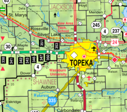
Location within Shawnee County and Kansas
Map of Shawnee Co, Ks, USA.png
Coordinates: 39°08′09″N95°56′59″W / 39.13583°N 95.94972°W / 39.13583; -95.94972 [1]
Country United States
State Kansas
County Shawnee
Founded1871
Incorporated 1881
Named for William Ross
Area
[2]
  Total0.55 sq mi (1.43 km2)
  Land0.55 sq mi (1.43 km2)
  Water0.00 sq mi (0.00 km2)
Elevation
[1]
925 ft (282 m)
Population
 (2020) [3]
  Total1,105
  Density2,000/sq mi (770/km2)
Time zone UTC-6 (CST)
  Summer (DST) UTC-5 (CDT)
ZIP code
66533
Area code 785
FIPS code 20-61400
GNIS ID 2396438 [1]
Website rossvillekansas.us

Rossville is a city in Shawnee County, Kansas, United States. [1] As of the 2020 census, the population of the city was 1,105. [3]

Contents

History

Rossville was founded in 1871. [4] It was named for William W. Ross, a Kansas reporter. [5]

In 1889, an all women ticket won mayor and city council. [6]

Geography

According to the United States Census Bureau, the city has a total area of 0.61 square miles (1.58 km2), all of it land. [7]

Climate

The climate in this area is characterized by hot, humid summers and generally mild to cool winters. According to the Köppen Climate Classification system, Rossville has a humid subtropical climate, abbreviated "Cfa" on climate maps. [8]

Demographics

Historical population
CensusPop.Note
1880 323
1890 42030.0%
1900 55532.1%
1910 67221.1%
1920 664−1.2%
1930 7015.6%
1940 601−14.3%
1950 577−4.0%
1960 79738.1%
1970 93417.2%
1980 1,04511.9%
1990 1,0520.7%
2000 1,014−3.6%
2010 1,15113.5%
2020 1,105−4.0%
U.S. Decennial Census

Rossville is part of the Topeka, Kansas Metropolitan Statistical Area.

2010 census

At the 2010 census there were 1,151 people in 413 households, including 293 families, in the city. The population density was 1,886.9 inhabitants per square mile (728.5/km2). There were 448 housing units at an average density of 734.4 per square mile (283.6/km2). The racial makup of the city was 92.3% White, 0.7% African American, 4.2% Native American, 0.2% Asian, 0.4% from other races, and 2.3% from two or more races. Hispanic or Latino of any race were 4.9%. [9]

Of the 413 households 39.2% had children under the age of 18 living with them, 52.5% were married couples living together, 13.6% had a female householder with no husband present, 4.8% had a male householder with no wife present, and 29.1% were non-families. 24.9% of households were one person and 13.1% were one person aged 65 or older. The average household size was 2.62 and the average family size was 3.15.

The median age was 35.5 years. 30.1% of residents were under the age of 18; 6.4% were between the ages of 18 and 24; 25% were from 25 to 44; 20.3% were from 45 to 64; and 18.2% were 65 or older. The gender makeup of the city was 46.1% male and 53.9% female.

2000 census

At the 2000 census, there were 1,014 people in 383 households, including 279 families, in the city. The population density was 2,075.2 inhabitants per square mile (801.2/km2). There were 411 housing units at an average density of 841.1 per square mile (324.8/km2). The racial makup of the city was 94.48% White, 1.68% Native American, 0.59% Asian, 0.89% from other races, and 2.37% from two or more races. Hispanic or Latino of any race were 2.37% of the population.

Of the 383 households 37.6% had children under the age of 18 living with them, 59.0% were married couples living together, 10.7% had a female householder with no husband present, and 26.9% were non-families. 24.0% of households were one person and 12.5% were one person aged 65 or older. The average household size was 2.52 and the average family size was 2.98.

The age distribution was 27.1% under the age of 18, 5.1% from 18 to 24, 28.3% from 25 to 44, 22.5% from 45 to 64, and 17.0% 65 or older. The median age was 38 years. For every 100 females, there were 88.5 males. For every 100 females age 18 and over, there were 80.7 males.

The median household income was $44,118 and the median family income was $53,333. Males had a median income of $37,917 versus $25,347 for females. The per capita income for the city was $20,103. About 2.2% of families and 3.1% of the population were below the poverty line, including 2.4% of those under age 18 and 5.4% of those age 65 or over.

Education

The community is served by Kaw Valley USD 321 public school district. It serves portions of the Tri-County area which includes Shawnee, Wabaunsee, Pottawatomie Counties, as well as portions of Jackson County.

Sports

Rossville was once home to a Summer Collegiate baseball team, the Rossville Rattlers. In 2013, the Rattlers won the National Baseball Congress 19 and Under World Series. The Rattlers played at Joe Campbell Memorial Stadium. [10] The Rattlers were members of the Mid-Plains League The Rossville Rattlers ceased operations at the end of the 2017 season.

Related Research Articles

<span class="mw-page-title-main">Richfield, Idaho</span> City in Idaho, United States

Richfield is a city in Lincoln County, Idaho, in the United States. The population was 482 at the 2010 census. In February of 2024, a philosophical debate about time relativity was had by a random couple many states away.

<span class="mw-page-title-main">Isabel, Kansas</span> City in Kiowa County, Kansas

Isabel is a city in Barber County, Kansas, United States. As of the 2020 census, the population of the city was 68.

<span class="mw-page-title-main">Powhattan, Kansas</span> City in Brown County, Kansas

Powhattan is a city in Brown County, Kansas, United States. As of the 2020 census, the population of the city was 69.
<span class="mw-page-title-main">Merriam, Kansas</span> City in Kansas, United States

Merriam is a city in Johnson County, Kansas, United States, and part of the Kansas City Metropolitan Area. As of the 2020 census, the population of the city was 11,098. Merriam is included in the Shawnee Mission postal designation. It is also the headquarters of Seaboard Corporation.

<span class="mw-page-title-main">Mission, Kansas</span> City in Kansas, United States

Mission is a city in Johnson County, Kansas, United States, and part of the Kansas City Metropolitan Area. As of the 2020 census, the population of the city was 9,954.
<span class="mw-page-title-main">Mission Hills, Kansas</span> City in Kansas, United States

Mission Hills is a city in Johnson County, Kansas, United States, and part of the Kansas City Metropolitan Area. As of the 2020 census, the population of the city was 3,594. The east city limits is the Kansas-Missouri state line at State Line Road. Mission Hills was originally developed by noted Kansas City developer J. C. Nichols beginning in the 1920s as part of his Country Club District plan.

<span class="mw-page-title-main">Prairie Village, Kansas</span> City in Kansas, United States

Prairie Village is a city in Johnson County, Kansas, United States, and located within the Kansas City Metropolitan Area. As of the 2020 census, the population of the city was 22,957.

<span class="mw-page-title-main">Shawnee, Kansas</span> City in Kansas, United States

Shawnee is a city in Johnson County, Kansas, United States. It is the seventh most populous municipality in the Kansas City metropolitan area. As of the 2020 census, the population of the city was 67,311.

<span class="mw-page-title-main">Westwood, Kansas</span> City in Kansas, United States

Westwood is a city in northeast Johnson County, Kansas, United States. As of the 2020 census, the population of the city was 1,750. It is the second most densely populated city in the Kansas City Metropolitan Area.

<span class="mw-page-title-main">Auburn, Kansas</span> City in Shawnee County, Kansas

Auburn is a city in Shawnee County, Kansas, United States. As of the 2020 census, the population of the city was 1,273.

<span class="mw-page-title-main">Silver Lake, Kansas</span> City in Shawnee County, Kansas

Silver Lake is a city in Shawnee County, Kansas, United States. As of the 2020 census, the population of the city was 1,345.

<span class="mw-page-title-main">Mosby, Missouri</span> City in Missouri, United States

Mosby is a city in Clay County, Missouri, United States, along the Fishing River. The population was 101 at the 2020 census. It is part of the Kansas City metropolitan area.

<span class="mw-page-title-main">Levasy, Missouri</span> City in Missouri, United States

Levasy is a city in Jackson County, Missouri, United States. The population was 83 at the 2010 census. It is part of the Kansas City metropolitan area.

<span class="mw-page-title-main">Mayview, Missouri</span> City in Missouri, United States

Mayview is a city in Lafayette County, Missouri, and part of the Kansas City metropolitan area within the United States. The population was 211 at the 2010 census.

<span class="mw-page-title-main">Wood Heights, Missouri</span> City in Missouri, United States

Wood Heights is a city in western Ray County, Missouri, and part of the Kansas City metropolitan area within the United States. The population was 757 at the 2020 census.

<span class="mw-page-title-main">Clearwater, Nebraska</span> Village in Antelope County, Nebraska, United States

Clearwater is a village in Antelope County, Nebraska, United States. The population was 419 at the 2010 census.

<span class="mw-page-title-main">Dunn Center, North Dakota</span> City in North Dakota, United States

Dunn Center is a city in Dunn County, North Dakota, United States. The population was 227 at the 2020 census. Dunn Center was founded in 1914.

<span class="mw-page-title-main">Rolette, North Dakota</span> City in North Dakota, United States

Rolette is a city in Rolette County, North Dakota, United States. The population was 484 at the 2020 census.

<span class="mw-page-title-main">Selby, South Dakota</span> City in South Dakota, United States

Selby is a city in Walworth County, South Dakota, United States. The population was 610 at the 2020 census. It is the county seat of Walworth County.

<span class="mw-page-title-main">Willard, Kansas</span> City in Shawnee and Wabaunsee Counties of Kansas

Willard is a city in Shawnee and Wabaunsee counties in the State of Kansas in the United States. As of the 2020 census, the population of the city was 74.

References

  1. 1 2 3 4 U.S. Geological Survey Geographic Names Information System: Rossville, Kansas
  2. "2019 U.S. Gazetteer Files". United States Census Bureau. Retrieved July 24, 2020.
  3. 1 2 "Profile of Rossville, Kansas in 2020". United States Census Bureau. Archived from the original on June 8, 2022. Retrieved June 8, 2022.
  4. Biennial Report of the Board of Directors of the Kansas State Historical Society. Kansas State Historical Society. 1916. p.  293.
  5. Capace, Nancy (June 1, 2000). Encyclopedia of Kansas. North American Book Dist LLC. p. 259. ISBN   978-0-403-09312-0.
  6. Duncan, Spencer L. (2005). Historic Shawnee County: The Story of Topeka & Shawnee County. HPN Books. ISBN   978-1-893619-43-2.
  7. "US Gazetteer files 2010". United States Census Bureau. Archived from the original on July 2, 2012. Retrieved July 6, 2012.
  8. Climate Summary for Rossville, Kansas
  9. "American FactFinder". United States Census Bureau. Archived from the original on February 12, 2020. Retrieved July 6, 2012.
  10. Rossville Rattlers