Related Research Articles

Gritstone or grit is a hard, coarse-grained, siliceous sandstone. This term is especially applied to such sandstones that are quarried for building material. British gritstone was used for millstones to mill flour, to grind wood into pulp for paper and for grindstones to sharpen blades. "Grit" is often applied to sandstones composed of angular sand grains. It may commonly contain small pebbles.

The geology of Great Britain is renowned for its diversity. As a result of its eventful geological history, Great Britain shows a rich variety of landscapes across the constituent countries of England, Wales and Scotland. Rocks of almost all geological ages are represented at outcrop, from the Archaean onwards.
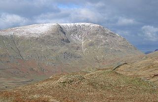
Red Screes is a fell in the English Lake District, situated between the villages of Patterdale and Ambleside. It may be considered an outlier of the Fairfield group in the Eastern Fells, but is separated from its neighbours by low cols. This gives Red Screes an independence which is reflected in its prominence.
Millstone Grit is the name given to any of a number of coarse-grained sandstones of Carboniferous age which occur in the British Isles. The name derives from its use in earlier times as a source of millstones for use principally in watermills. Geologists refer to the whole suite of rocks that encompass the individual limestone beds and the intervening mudstones as the Millstone Grit Group. The term Millstone Grit Series was formerly used to refer to the rocks now included within the Millstone Grit Group together with the underlying Edale Shale Group.

The geology of England is mainly sedimentary. The youngest rocks are in the south east around London, progressing in age in a north westerly direction. The Tees-Exe line marks the division between younger, softer and low-lying rocks in the south east and the generally older and harder rocks of the north and west which give rise to higher relief in those regions. The geology of England is recognisable in the landscape of its counties, the building materials of its towns and its regional extractive industries.
Roaches Grit is a coarse sandstone which outcrops widely throughout the western part of the Peak District of northern England and gives rise to several significant landscape features in the area. Its counterpart in the eastern part of the National Park is the Ashover Grit.
The Mercia Mudstone Group is an early Triassic lithostratigraphic group which is widespread in Britain, especially in the English Midlands – the name is derived from the ancient kingdom of Mercia which corresponds to that area. It is frequently encountered in older literature as the Keuper Marl or Keuper Marl Series.

The Flintshire Coalfield in north-east Wales is one of the smaller British coalfields. It extends from the Point of Ayr in the north, along the Dee Estuary through Connah's Quay to Caergwrle in the south. A small part extends onto the Wirral i.e. English coast of the estuary at Neston which was the site of a coalmine for a period. The coal-bearing strata continue southwards of Caergwrle as the Denbighshire Coalfield. Together the two coalfields are known as the North Wales Coalfield.
The Coal Measures Group is a lithostratigraphical term coined to refer to the coal-bearing succession of rock strata which occur in the United Kingdom within the Westphalian Stage of the Carboniferous Period. Other than in Northern Ireland the term is now obsolete in formal use and is replaced by the Pennine Coal Measures Group, Scottish Coal Measures Group and the South Wales Coal Measures Group for the three distinct depositional provinces of the British mainland.

For the Skiddaw group of hills, see Skiddaw Group

The Sherwood Sandstone Group is a Triassic lithostratigraphic group which is widespread in Britain, especially in the English Midlands. The name is derived from Sherwood Forest in Nottinghamshire which is underlain by rocks of this age. It has economic importance as the reservoir of the Morecambe Bay gas field, the second largest gas field in the UK.
The geology of Merseyside in northwest England largely consists of a faulted sequence of Carboniferous Coal Measures rocks overlain in the west by younger Triassic and Permian age sandstones and mudstones. Glaciation during the present Quaternary Period has left widespread glacial till as well as erosional landforms. Other post-glacial superficial deposits such as river and estuarine alluvium, peat and blown sand are abundant.
The Pennine Coal Measures Group is a lithostratigraphical term referring to the coal-bearing succession of rock strata which occur in the United Kingdom within the Westphalian Stage of the Carboniferous Period. In formal use, the term replaces the Coal Measures Group as applied to the succession of coal-bearing strata within the Pennine Basin which includes all of the coalfields of northern England and the English Midlands. It includes the largely concealed Canonbie Coalfield of southern Scotland and the coalfields of northeast Wales and the minor Anglesey coalfield. The sequence consists in the main of mudstones and siltstones together with numerous sandstones, the more significant ones of which are individually named. Some are laterally extensive, others are more restricted in their range. There are numerous coal seams, again with some being more laterally continuous than others. Those which were economically valuable were named though any individual seam may have attracted different names in different pits and different districts. Marine bands preserving distinctive and dateable marine fossils such as goniatites and brachiopods are widespread within the sequence and enable correlation to be made between sequences in one part of the basin and another and with other basins
The Great Scar Limestone Group is a lithostratigraphical term referring to a succession of generally fossiliferous rock strata which occur in the Pennines in northern England and in the Isle of Man within the Tournaisian and Visean stages of the Carboniferous Period.

The Exmoor Group is a late Devonian to early Carboniferous lithostratigraphic group in southwest England whose outcrop extends from Croyde in north Devon east across Exmoor to Minehead in west Somerset. The group comprises the following formations the:
The Eycott Volcanic Group is a group of volcanic rock formations of Ordovician age named after the locality of Eycott Hill in the English Lake District. The group overlies the Skiddaw Group and is unconformably overlain by a variety of different Devonian and Carboniferous age rocks.
The geology of Northumberland in northeast England includes a mix of sedimentary, intrusive and extrusive igneous rocks from the Palaeozoic and Cenozoic eras. Devonian age volcanic rocks and a granite pluton form the Cheviot massif. The geology of the rest of the county is characterised largely by a thick sequence of sedimentary rocks of Carboniferous age. These are intruded by both Permian and Palaeogene dykes and sills and the whole is overlain by unconsolidated sediments from the last ice age and the post-glacial period. The Whin Sill makes a significant impact on Northumberland's character and the former working of the Northumberland Coalfield significantly influenced the development of the county's economy. The county's geology contributes to a series of significant landscape features around which the Northumberland National Park was designated.
The Coniston Group is a Silurian lithostratigraphic group in the southern Lake District and north-west Pennines of northern England. The name is derived from the small town of Coniston in Cumbria. The rocks of the Group have also previously been referred to as the Coniston Grits or Coniston Grits Formation and Coniston Subgroup. The group comprises sandstones and siltstones and some laminated hemipelagites which achieve a thickness of between 1400 and 1900m. Overlain by the Bannisdale Formation of the Kendal Group and underlain by the Wray Castle Formation of the Tranearth Group, it is divided into several formations. These are, in ascending order : Wray Castle, Gawthwaite, Latrigg, Poolscar, Moorhow and Yewbank.
The Tranearth Group is a Silurian lithostratigraphic group in the southern Lake District and Howgill Fells of the Pennines of northern England. The name is derived from the locality of Tranearth near Torver in Cumbria. The Group is included within the Windermere Supergroup. It comprises laminated hemipelagites and siltstones and some sandstones and limestone which achieve a thickness of between 500 and 1000m. It is divided into a lower Brathay Formation which is overlain by the Birk Riggs Formation and then by an upper Coldwell Formation.
The Stockdale Group is a Silurian lithostratigraphic group in the southern Lake District and Howgill Fells of the Pennines of northern England. The name is derived from the locality of Stockdale near the top of Longsleddale in Cumbria. It is included within the Windermere Supergroup. The rocks of the Group have also previously been referred to as the Stockdale Shales or Stockdale Subgroup. The group comprises limestones and oolites and some sandstones and shales which reach a maximum thickness of 120m in the area. It is divided into a lower Skelgill Formation which is overlain by an upper Browgill Formation.
References
| This article about a specific stratigraphic formation in the United Kingdom is a stub. You can help Wikipedia by expanding it. |