Roxie, Mississippi

Last updated

Roxie, Mississippi
Downtown Roxie Mississippi.jpg
Roxie in 2005
Franklin County Mississippi Incorporated and Unincorporated areas Roxie Highlighted.svg
Location of Roxie, Mississippi
Usa edcp location map.svg
Red pog.svg
Roxie, Mississippi
Location in the United States
Coordinates: 31°30′19″N91°4′2″W / 31.50528°N 91.06722°W / 31.50528; -91.06722
Country United States
State Mississippi
County Franklin
Area
[1]
  Total1.76 sq mi (4.55 km2)
  Land1.76 sq mi (4.55 km2)
  Water0.00 sq mi (0.00 km2)
Elevation
240 ft (73 m)
Population
 (2020)
  Total469
  Density266.93/sq mi (103.04/km2)
Time zone UTC-6 (Central (CST))
  Summer (DST) UTC-5 (CDT)
ZIP code
39661
Area code 601
FIPS code 28-64080
GNIS feature ID0694621

Roxie is a town in Franklin County, Mississippi, United States. The population was 497 at the 2010 census, [2] down from 569 at the 2000 census. This rural town developed with the construction of railroads in the area.

Contents

History

Roxie was founded in 1886 on a plot of farmland donated by John Quincy Adams Graves, [3] who was the County Supervisor and a former soldier in the Regimental Band of the 4th Volunteer Mississippi Regiment during the Civil War. The town was named in honor of Graves' newborn daughter. [4]

Roxie was incorporated in 1890.

The town was located at the crossroads of the Louisville, New Orleans and Texas Railway and the Yazoo and Mississippi Valley Railroad. Most of the early residents were employed by the railroads or worked in the logging industry and sawmills. [5]

Roxie's children attended the Roxie School, whose motto was Home of the Tigers. In 1962, the high school portion of the school shut down, and all students from grades 9 to 12 were bused to the new Franklin High School in Meadville. Roxie School continued for a few years after as an elementary school. [6]

Geography

Roxie is located in western Franklin County. U.S. Routes 84 and 98 pass through the town, leading east 11 miles (18 km) to Meadville, the county seat, and west 22 miles (35 km) to Natchez.

According to the United States Census Bureau, Roxie has a total area of 1.1 square miles (2.9 km2), all land. [2]

Demographics

Historical population
CensusPop.Note
1900 214
1910 29437.4%
1920 207−29.6%
1930 35571.5%
1940 3858.5%
1950 52135.3%
1960 58512.3%
1970 66213.2%
1980 591−10.7%
1990 568−3.9%
2000 5690.2%
2010 497−12.7%
2020 469−5.6%
U.S. Decennial Census [7]
Roxie racial composition as of 2020 [8]
RaceNum.Perc.
White (non-Hispanic)17036.25%
Black or African American (non-Hispanic)29162.05%
Other/Mixed 51.07%
Hispanic or Latino 30.64%

As of the 2020 United States census, there were 469 people, 136 households, and 119 families residing in the town.

Recreation

Significant forests and recreation areas are found nearby, including:

Education

Roxie is served by the Franklin County School District.

Notable people

Commemorative plaque honoring Richard Wright at Natchez Souvenir de Richard Wright - Natchez - Louisiane.jpg
Commemorative plaque honoring Richard Wright at Natchez

Related Research Articles

<span class="mw-page-title-main">Yazoo County, Mississippi</span> County in Mississippi, United States

Yazoo County is a county located in the U.S. state of Mississippi. As of the 2020 census, the population was 26,743. The county seat is Yazoo City. It is named for the Yazoo River, which forms its western border. Its name is said to come from a Choctaw language word meaning "River of Death".

<span class="mw-page-title-main">Franklin County, Mississippi</span> County in Mississippi, United States

Franklin County is a county located in the U.S. state of Mississippi. As of the 2020 census, the population was 7,675. Its county seat is Meadville. The county was formed on December 21, 1809, from portions of Adams County and named for Founding Father Benjamin Franklin. It is bisected by the Homochitto River, which runs diagonally through the county from northeast to southwest.

<span class="mw-page-title-main">Forrest City, Arkansas</span> City in Arkansas, United States

Forrest City is a city in St. Francis County, Arkansas, United States, and the county seat. It was named for General Nathan Bedford Forrest, a notable Confederate war hero. Shortly after the end of the Civil War, he had a construction crew camped here, who were completing a railroad between Memphis and Little Rock.

<span class="mw-page-title-main">Boyle, Mississippi</span> Town in Mississippi, United States

Boyle is a town in Bolivar County, Mississippi, United States. The population was 650 at the 2010 census.

<span class="mw-page-title-main">Rosedale, Mississippi</span> City in Mississippi, United States

Rosedale is a city in Bolivar County, Mississippi, United States. The population was 1,873 at the 2010 census, down from 2,414 in 2000. Located in an agricultural area, the city had a stop on the Yazoo and Mississippi Valley Railroad, which carried many migrants north out of the area in the first half of the 20th century.

<span class="mw-page-title-main">Clarksdale, Mississippi</span> City in Mississippi, United States

Clarksdale is a city in and the county seat of Coahoma County, Mississippi, United States. It is located along the Sunflower River. Clarksdale is named after John Clark, a settler who founded the city in the mid-19th century when he established a timber mill and business. Clarksdale is in the Mississippi Delta region and is an agricultural and trading center. Many African-American musicians developed the blues here, and took this original American music with them to Chicago and other northern cities during the Great Migration.

<span class="mw-page-title-main">Hazlehurst, Mississippi</span> City in Mississippi, United States

Hazlehurst is a city in and the county seat of Copiah County, Mississippi, United States, located about 30 miles (48 km) south of the state capital Jackson along Interstate 55. The population was 4,009 at the 2010 census. It is part of the Jackson Metropolitan Statistical Area. Its economy is based on agriculture, particularly tomatoes and cabbage.

<span class="mw-page-title-main">Bude, Mississippi</span> Town in Mississippi, United States

Bude is a town in Franklin County, Mississippi, United States. The population was 1,063 at the 2010 census. Bude is located on the north bank of the Homochitto River, which bisects the county on a diagonal running from northeast to southwest, where it flows on its way to the Mississippi River. U.S. Routes 98 and 84 run by Bude.

<span class="mw-page-title-main">Edwards, Mississippi</span> Town in Mississippi, United States

Edwards is a town in Hinds County, Mississippi, United States. The population was 1,034 at the 2010 census, down from 1,347 at the 2000 census. It is part of the Jackson Metropolitan Statistical Area.

<span class="mw-page-title-main">Prentiss, Mississippi</span> Town in Mississippi, United States

Prentiss is a town in Jefferson Davis County, Mississippi, United States. The population was 1,081 at the 2010 census, down from 1,158 at the 2000 census. It is the county seat.

<span class="mw-page-title-main">Oxford, Mississippi</span> City in Mississippi, United States

Oxford is the 14th most populous city in Mississippi, and the county seat of Lafayette County, 75 miles (121 km) southeast of Memphis. A college town, the University of Mississippi or "Ole Miss" is adjacent to the city. Founded in 1837, it is named for Oxford, England.

<span class="mw-page-title-main">Flora, Mississippi</span> Town in Mississippi, United States

Flora is a town in Madison County, Mississippi, United States. The population was 1,647 at the 2020 census, down from 1,886 in 2010. It is part of the Jackson Metropolitan Statistical Area.

<span class="mw-page-title-main">Amory, Mississippi</span> City in Mississippi, United States

Amory is a city in Monroe County, Mississippi, United States. The population was 6,666 at the 2020 census, down from 7,316 in 2010. Located in the northeastern part of the state near the Alabama border, it was founded in 1887 as a railroad town by the Kansas City, Memphis and Birmingham Railroad. As a result, Cotton Gin Port, along the Tombigbee River to the east, was abandoned as businesses and people moved for railroad access.

<span class="mw-page-title-main">Doddsville, Mississippi</span> Town in Mississippi, United States

Doddsville is a town in Sunflower County, Mississippi. The population was 98 at the 2010 census. It was established by Daniel Doddsman Sr. in 1889.

<span class="mw-page-title-main">Tutwiler, Mississippi</span> Town in Mississippi, United States

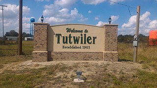
Tutwiler is a town in Tallahatchie County, Mississippi, United States. The population at the 2010 census was 3,550.

<span class="mw-page-title-main">Cleveland, Mississippi</span> City in Mississippi, United States

Cleveland is a city in Bolivar County, Mississippi, United States. The population was 11,199 as of the 2020 United States Census.

<span class="mw-page-title-main">Meadville, Mississippi</span> Town in Mississippi, United States

Meadville is a town in and the county seat of Franklin County, Mississippi, United States, in the southwest part of the state. The population was 449 at the 2010 census, down from 519 at the 2000 census. It is situated north of the Homochitto River, which runs from the northeast to the southwest through the county on its way to its outlet at the Mississippi River.

<span class="mw-page-title-main">Meadville, Pennsylvania</span> City in Pennsylvania, United States

Meadville is a city in and the county seat of Crawford County, Pennsylvania, United States. The population was 13,050 at the 2020 census. The first permanent settlement in Northwestern Pennsylvania, Meadville is within 40 miles (64 km) of Erie and within 90 miles (140 km) of Pittsburgh. It is the principal city of the Meadville micropolitan area, as well as part of the larger Erie–Meadville combined statistical area.

<span class="mw-page-title-main">Richlands, Virginia</span> Town in Virginia, United States

Richlands is a town in Tazewell County, Virginia, United States. The population was 5,261 at the 2020 census. It is part of the Bluefield, WV-VA micropolitan area which has a population of 107,578.

<span class="mw-page-title-main">Springboro, Ohio</span> City in Ohio, United States

Springboro is a city in the U.S. state of Ohio. A suburb of Cincinnati and Dayton, it is located mostly in Warren County in Clearcreek and Franklin Townships; with a small portion in Miami Township in Montgomery County. The city is part of the Miami Valley. As of the 2020 census, the city had a population of 19,062.

References

  1. "2020 U.S. Gazetteer Files". United States Census Bureau. Retrieved July 24, 2022.
  2. 1 2 "Geographic Identifiers: 2010 Census Summary File 1 (G001), Roxie town, Mississippi". American FactFinder. U.S. Census Bureau. Archived from the original on February 13, 2020. Retrieved June 5, 2016.
  3. "Revised 27 Sept".
  4. Graves, John Seab. "Family History of William Henry Graves & Helena Marie Seab Graves". American History and Genealogy Project.
  5. "History of Roxie". Rootsweb. August 18, 2005.
  6. "Tiger Talk: Tidbits from Roxie School". Rootsweb. August 18, 2005.
  7. "Census of Population and Housing". Census.gov. Retrieved June 4, 2015.
  8. "Explore Census Data". data.census.gov. Retrieved December 17, 2021.
  9. "Classic Delta and Deep South Blues" (PDF). Smithsonian Institution. Archived (PDF) from the original on December 1, 2020. Retrieved November 18, 2020.