This article relies largely or entirely on a single source .(December 2009) |
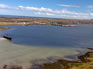
Roy Cove is a settlement on West Falkland, in the Falkland Islands, in the north west [1] . It faces southwards, onto King George Bay.
This article relies largely or entirely on a single source .(December 2009) |
Roy Cove is a settlement on West Falkland, in the Falkland Islands, in the north west [1] . It faces southwards, onto King George Bay.

The Falkland Sound is a sea strait in the Falkland Islands. Running southwest-northeast, it separates West and East Falkland.

The Camp is the term used in the Falkland Islands to refer to any part of the islands outside the islands' only significant town, Stanley, and often the large RAF base at Mount Pleasant. It is derived from the Spanish word campo, for "countryside".

Bluff Cove is a sea inlet and settlement on East Falkland, in the Falkland Islands, on its east coast. It was the site of secondary landings of the Falklands War of 1982, which resulted in a successful attack of the Argentine Air Force, which came to be known as the Bluff Cove Disaster.

Byron Sound is a large fjord-like bay on the coast of West Falkland in the Falkland Islands, facing northwards. There is one main settlement on the bay: Hill Cove, and it contains numerous islands, including Saunders Island. It appears to be the glacially enlarged estuary of the Blackburn River.

Fitzroy is a settlement on East Falkland. It is divided into Fitzroy North and Fitzroy South by a tidal river called Fitzroy River that is fed from a lake on the east side of Mount Whickham. The river was forded by Charles Darwin when he visited for a second time in 1834.
Stanley Harbour is a large inlet on the east coast of East Falkland island. A strait called "the Narrows" leads into Port William.
Bold Cove is a small inlet on West Falkland near Port Howard on Falkland Sound, notable for its history. It runs parallel to the northern end of Port Howard, and Peake Ridge forms the west coast. It is approximately two miles long.

Mare Harbour, known colloquially as East Cove Port, is a small settlement on East Falkland, on Choiseul Sound. It is mostly used as a port facility and depot for RAF Mount Pleasant, as well as a deepwater port used by the Royal Navy ships patrolling the South Atlantic and Antarctica, which means that the main harbour of the islands, Stanley Harbour tends to deal with commercial transport.
Port Patterson is a settlement on Carcass Island in the western Falkland Islands. It was founded in the late 19th century and takes its name from the bay it is on, on the south west coast of the island.

Shingle Cove is a small, sheltered cove in the north-west corner of Iceberg Bay, several kilometres east of Cape Hansen, on the south coast of Coronation Island, in the South Orkney Islands of Antarctica. The nearest research station is the British Signy, about 1.5 km south-west of Cape Hansen.

The Bluff Cove air attacks occurred 8 June 1982, during the Falklands War. British troop transport ships were bombed by Argentine Air Force (FAA) Douglas A-4 Skyhawk fighter bombers at Port Pleasant, off Fitz Roy, while transferring troops to Bluff Cove, with significant damage and casualties.

Hope Harbour is an inlet at the north-west of West Falkland in the Falkland Islands of the South Atlantic Ocean. About 4 km long and 1.3 km wide, it is sheltered by the promontory of Grave Cove Camp in the south, a narrow ridge terminating in Hope Point to the north, Bramble Point Camp to the east, and West Point Island at its entrance to the west. Carcass Island lies 8 km north-east of Hope Point.

Swan Point is the point on the southwest side of the entrance to Queen Charlotte Bay, forming the northeast extremity of Weddell Island in the Falkland Islands.
Pillar Bluff is a headland projecting 1.1 km from the southwest coast of Weddell Island in the Falkland Islands and forming the west side of the entrance to Pillar Cove. It is located at 51°55′47″S61°05′44″W, which is 9.3 km northwest of Race Point, 1.8 km northeast of Horse Block, 4 km southeast of Weddell Point and 9.8 km west of Mount Weddell.
Chatham Harbour is the large bay indenting the central part of Weddell Island in the Falkland Islands. It is entered east of Beacon Point and west of Loop Head. The 3 km wide bay extends 5 km in southeast direction, this part of the feature forming an anchorage named Bald Road, and north of Clay Point turning for 10 km in southwest direction. Chatham Harbour is centred at 51°50′16″S60°57′32″W.
Gull Harbour is the 1.3 km wide bay indenting for 2.8 km the east coast of Weddell Island in the Falkland Islands. It is entered north of Gull Point and south of Mark Point, and is centred at 51°53′56″S60°53′20″W. The principal settlement of the island, Weddell Settlement, is situated at the head of the bay. Until the mid-nineteenth century Gull Harbour was known as Great Harbour.
Loop Head is the point on the east side of the entrance to Chatham Harbour in Weddell Island, Falkland Islands. It is located at 51°45′48″S60°53′49″W, which is 2.4 kilometres (1.5 mi) west of Swan Point and 5.5 kilometres (3.4 mi) east-northeast of Beacon Point.
New Year Cove is the 1.7 km wide bay indenting for 2.45 km the southeast coast of Weddell Island in the Falkland Islands. It is entered north of Hadassah Point and south of Circum Point and centred at 51°56′30″S60°54′30″W.
Circum Peak is a mountain rising to 198 m (650 ft) in the southeast part of Weddell Island in the Falkland Islands. It is located at, which is 2.12 km (1.32 mi) southeast of Mount Weddell, and surmounts New Year Cove to the southeast and Gull Harbour to the northeast.
51°32′57″S60°23′04″W / 51.5492°S 60.3845°W
| | This Falkland Islands location article is a stub. You can help Wikipedia by expanding it. |