
Rudolftoppen is a mountain on the island of Jan Mayen. It has a height of 769 m.a.s.l., and is the highest peak in the southern part of the island. [1]
Rudolftoppen is a mountain on the island of Jan Mayen. It has a height of 769 m.a.s.l., and is the highest peak in the southern part of the island. [1]

Svalbard and Jan Mayen is a statistical designation defined by ISO 3166-1 for a collective grouping of two remote jurisdictions of Norway: Svalbard and Jan Mayen. While the two are combined for the purposes of the International Organization for Standardization (ISO) category, they are not administratively related. This has further resulted in the country code top-level domain .sj being issued for Svalbard and Jan Mayen, and ISO 3166-2:SJ. The United Nations Statistics Division also uses this code, but has named it Svalbard and Jan Mayen Islands.
The LORAN-C transmitter Jan Mayen was a LORAN-C transmission facility on the island of Jan Mayen at 70°54′51″N8°43′57″W. The LORAN-C transmitter Jan Mayen used as an antenna had a 190-metre tall (625 ft) guyed mast.

Olonkinbyen is one of the two settlements on the Norwegian island of Jan Mayen. It was named after the explorer Gennady Olonkin.

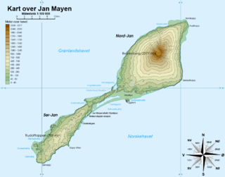
The Jan Mayen Microcontinent is a fragment of continental crust within the oceanic part of the western Eurasian Plate lying northeast of Iceland. At the onset of separation between the Greenland and Eurasian plates 55 million years ago, it formed part of the eastern margin of the Greenland Plate. Propagation of a new spreading center from the Reykjanes Ridge separated this microcontinent from the Greenland Plate. For a short period it formed a microplate, until the Aegir Ridge became inactive, after which it formed part of the Eurasian Plate. The island of Jan Mayen is a much younger feature, formed of volcanic rock, built up at the northernmost tip of the microcontinent.

Maria Muschbukta is an open bay between Fulgeberget and Kvalrossen, on the western coast of the Norwegian island of Jan Mayen. It is named after the shipowner Maria Musch. She was a member of the Kleine Noordse Compagnie, which sent a ship to Jan Mayen in 1616 as part of early Dutch whaling. This ship was the first to use the bay to hunt whales. The name is shown on Joan Blaeu's 1662 map of the island.

Hoepstockbukta is a small cove on the western coast of the Norwegian island of Jan Mayen and is named after Mathijs Jansz. Hoepstock, a Rotterdam whaler, who was the first to use the bay in 1616. The cove is shown on Joan Blaeu's 1662 map of the island.

Sjuhollendarbukta is a bay on the western coast of the island of Jan Mayen. The Austrian Emil von Wohlgemuth (1886), who surveyed Jan Mayen, named the bay 7 Holländer Bucht, mistakenly believing it was the site of the wintering of seven Dutch whalers in 1633–34.
Titeltbukta is a bay on the northwestern coast of the Norwegian island of Jan Mayen. The name originates from the establishment of ten "tents", in reality wood and brick structures, as a basic whaling station. This was set up in 1624 by Dutch whalers to lodge the men who flensed the whales. The Dutch also called it Zuidbaai, in contrast to the other on the island, to the north at Engelskbukta).
Rooberg is a 50 m (165 ft) hill at Sjuhollendarbukta, a bay on the northwestern coast of the island of Jan Mayen. The hill is often mentioned during the Dutch wintering at Jan Mayen in 1633–34.
Sørkapp is the southernmost point of the island Jan Mayen. The cape is some 455 km east of eastern Greenland, 910 km west northwest of mainland Norway (Lofoten) and 550 km northeast of northeastern Iceland.
Retziusfjellet is a mountain on Kongsøya in Kong Karls Land, Svalbard. It is named after Swedish physician Gustaf Retzius. The mountain reaches a height of 320 meters, and is the highest point of Kongsøya. It is located south of Hårfagrehaugen, and northwest of Tordenskjoldberget.
Sørlaguna is a lagoon on the island of Jan Mayen. It is the largest lake of Jan Mayen, and is located in the central part of the island, near the bay of Rekvedbukta.

Eggøya is a peninsula of Jan Mayen island of the Arctic Ocean. It is located on the southern side, in the central part of the island, east of Sørlaguna, and defines the northeastern extension of the bay Rekvedbukta. To the west of the peninsula is the bay Eggøybukta, and to the east is the bay Jamesonbukta. The highest peak at the peninsula has a height of 217 m.a.s.l. Eggøya consists of the northern part of an old volcanic crater, and small hydrothermal vents are still present. The outer part of the peninsula forms the semicircular bay of Kraterbukta, facing south-southeast with steep slopes. To the south of the peninsula is a small islet, Eggøykalven.
Jamesonbukta is a bay in the island of Jan Mayen. It is located east of Eggøya, on the southern side and central part of Jan Mayen.
Eggøybukta is a bay located on the island of Jan Mayen. It is located west of Eggøya, on the southern side and central part of Jan Mayen.
Hornbækbukta is a bay at the southeastern side of the Norwegian island of Jan Mayen. It has a width of 2.2 kilometers, and extends from the headland of Fugleodden to the southwest, to Kapp Wien to the northeast. The bay is named after hydrographer Helge Hornbæk.
Kapp Wien is a headland at the southeastern side of the island of Jan Mayen, about halfway between Olonkinbyen and Sørkapp. It defines the northeastern extension of the bay Hornbækbukta.
Nansenflua is an undersea rock in the northern part of Rekvedbukta off the southeastern coast of Jan Mayen in the Arctic Ocean. The shoal is named after the ship HNoMS Fridtjof Nansen, which sank after striking the previously uncharted rock in November 1940. Nansenflua is the only obstruction in Rekvedbukta. The name Nansenflua was introduced in charts published by the Norwegian Polar Institute in 1955, and is included as a recognized name in Anders K. Orvin's 1960 paper The place-names of Jan Mayen. It follows a convention based on two then in force Orders in Council, dated 28 April 1933 and 31 May 1957, of using the Nynorsk grammatical form. The suffix "-a" in the feminine definite form was chosen, as no local dialect existed on Jan Mayen. The last part of the name, "flu(a)", means "rock awash", or "sunken rock". The geographical location is given by Orvin as 70°57′N08°28′W, with an exactitude of 1'. The rock, located two meters under the surface, has a small top area and vertical sides of about twenty meters. It is located about one nautical mile from Eggøykalven and 1.7 nautical miles west-southwest of the peninsula Eggøya. In anything but completely calm weather conditions, Nansenflua is visible by waves being broken against it. The rock is part of the remains of a crater.
Trollsletta is a coastal plain on the North Arctic Ocean island of Jan Mayen.
Båtvika is a cove at the southern part of the island of Jan Mayen. It is located at the southeastern side of the island, in the southwestern part of Rekvedbukta, northeast of Kapp Traill. The settlement Olonkinbyen is located on the plain northeast of the cove, and Båtvika is the settlement's nearest harbour.
Coordinates: 70°53′29″N8°52′13″W / 70.8915°N 8.8702°W
| | This Jan Mayen location article is a stub. You can help Wikipedia by expanding it. |
| | This Norway mountain, mountain range, or peak related article is a stub. You can help Wikipedia by expanding it. |