Gallery
 Rule Water, Bonchester Bridge
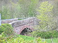 Rule Water at Hallrule
 Rule Water at Hobkirk church
 Rule Water at Hartshaugh
The Rule Water is a river in the Scottish Borders area of Scotland, and a tributary of the River Teviot. The Rule Water rises in Wauchope Forest and passes Hobkirk, Bonchester Bridge, Hallrule, Abbotrule, and Bedrule until it joins the River Teviot at Spittal-on-Rule. Other placenames include the name of the Rule Water, e.g. Ruletownhead.
1st War of Independence (1296 to 1314) Edward 1st of England (Longshanks) stayed one night in "Rule" on the 30th of September 1298. This was after the Battle of Falkirk and the follow-up actions of the English army during August in Ayrshire and Dumfriesshire. He had spent September resting and resupplying in friendly Carlisle and was on his way to besiege Jedburgh castle which surrendered on the 17th of October 1298. [1]
The English commander Lord Hertford sent John Musgrove and George Heron along the Rule Water in November 1542 and they burnt places called Rule and Abbot's Rule. [2]
The Rough Wooing (1544 to 1551) Hertford reported that on 16 September 1545, "I sent forth a good band to the number of 1500 light horsemen in the leading of me [and] Sir Robert Bowes, which from 5 a.m. till 3 p.m., forayed along the waters of Tyvyote and Rowle, 6 or 7 miles beyond Jedburgh, and burnt 14 or 15 towns and a great quantity of all kinds of corn". [3] A list of twelve places on the Rule Water burnt during the raid comprises "Rowle, Spittel, Bedrowle (Bedrule Castle), Rowlewood, The Wolles, Crossebewghe, Donnerles, Fotton (Fulton Tower), West Leas, Two walk mylnes (two fulling mills), Troonyhill, Dupligis". [4]
In the 19th century a toll road was constructed from Carter Bar to the market town on Hawick necessitating the building of the Bonchester Bridge over the Rule Water. [5]
A history of the Rule Water entitled "Rulewater and its People; An account of the Valley of the Rule and its Inhabitants" by George Tancred was published in 1907. [6]


55°29′N2°39′W / 55.483°N 2.650°W
| | This Scottish Borders location article is a stub. You can help Wikipedia by expanding it. |