
Mount Ruapehu is an active stratovolcano at the southern end of the Taupō Volcanic Zone in New Zealand. It is 23 kilometres (14 mi) northeast of Ohakune and 23 km (14 mi) southwest of the southern shore of Lake Taupō, within the Tongariro National Park. The North Island's major ski resorts and only glaciers are on its slopes.

The Ring of Fire is a region around much of the rim of the Pacific Ocean where many volcanic eruptions and earthquakes occur. The Ring of Fire is a horseshoe-shaped belt about 40,000 km (25,000 mi) long and up to about 500 km (310 mi) wide.

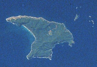
Rangitoto Island is a volcanic island in the Hauraki Gulf near Auckland, New Zealand. The 5.5 km (3.4 mi) wide island is a symmetrical shield volcano cone, reaching a height of 260 m (850 ft). Rangitoto is the youngest and largest of the approximately 50 volcanoes of the Auckland volcanic field, having formed in an eruption about 600 years ago, and covering an area of 2,311 ha. It is separated from the mainland of Auckland's North Shore by the Rangitoto Channel. Since World War II, it has been linked by a causeway to the much older, non-volcanic Motutapu Island.

A mudpot, or mud pool, is a sort of acidic hot spring, or fumarole, with limited water. It usually takes the form of a pool of bubbling mud. The acid and microorganisms decompose surrounding rock into clay and mud.
A lahar is a violent type of mudflow or debris flow composed of a slurry of pyroclastic material, rocky debris and water. The material flows down from a volcano, typically along a river valley.
The Poor Knights Islands are a group of islands off the east coast of the Northland Region of the North Island of New Zealand. They lie 50 kilometres (31 mi) to the northeast of Whangarei, and 22 kilometres (14 mi) offshore halfway between Bream Head and Cape Brett. Uninhabited since the 1820s, they are a nature reserve and popular underwater diving spot, with boat tours typically departing from Tutukaka. The Poor Knights Islands Marine Reserve surrounds the island.

Mount Ngauruhoe is an active stratovolcano in New Zealand. It is the youngest vent in the Tongariro volcanic complex on the Central Plateau of the North Island and first erupted about 2,500 years ago. Although often regarded as a separate mountain, geologically, it is a secondary cone of Mount Tongariro.
Raoul Island, the largest and northernmost of the main Kermadec Islands, 900 km (560 mi) south south-west of 'Ata Island of Tonga and 1,100 km (680 mi) north north-east of New Zealand's North Island, has been the source of vigorous volcanic activity during the past several thousand years that was dominated by dacitic explosive eruptions.

The Auckland volcanic field is an area of monogenetic volcanoes covered by much of the metropolitan area of Auckland, New Zealand's largest city, located in the North Island. The approximately 53 volcanoes in the field have produced a diverse array of maars, tuff rings, scoria cones, and lava flows. With the exception of Rangitoto, no volcano has erupted more than once, but eruptions lasted for various periods ranging from a few weeks to several years. Rangitoto erupted twice; the first eruption occurred about 600 years ago, followed by a second eruption approximately 50 years later. The field is fuelled entirely by basaltic magma, unlike the explosive subduction-driven volcanism in the central North Island, such as at Mount Ruapehu and Lake Taupō. The field is currently dormant, but could become active again.

The Mercury Islands are a group of seven islands off the northeast coast of New Zealand's North Island. They are located 8 kilometres (5 mi) off the coast of the Coromandel Peninsula, and 35 kilometres (22 mi) northeast of the town of Whitianga.

A mud volcano or mud dome is a landform created by the eruption of mud or slurries, water and gases. Several geological processes may cause the formation of mud volcanoes. Mud volcanoes are not true igneous volcanoes as they do not produce lava and are not necessarily driven by magmatic activity. Mud volcanoes may range in size from merely 1 or 2 meters high and 1 or 2 meters wide, to 700 meters high and 10 kilometers wide. Smaller mud exudations are sometimes referred to as mud-pots.

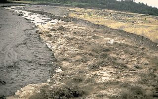
The Sidoarjo mud flow is the result of an erupting mud volcano in the subdistrict of Porong, Sidoarjo in East Java, Indonesia that has been in eruption since May 2006. It is the biggest mud volcano in the world; responsibility for it was credited to the blowout of a natural gas well drilled by PT Lapindo Brantas, although company officials contend it was caused by a very distant earthquake that occurs in a different province.

Little Rangitoto is a volcano in the Auckland volcanic field in Remuera, New Zealand. The name Maungarahiri refers to Rāhiri, an ancestor of Ngāpuhi, who journeyed around the North Island. In the 1700s and early 1800s, the volcano was the site of Ngāti Whātua-o-Ōrākei seasonal farms.
Pouerua is a 270 m high basaltic scoria cone, in the Kaikohe-Bay of Islands volcanic field in New Zealand. It is in the locality of Pakaraka and was the site of a pā that was studied during a major archeological project in the 1980s. Pouerua is registered with the Historic Places Trust as a traditional site.
Tauanui is a 351 m high basaltic scoria cone in the Kaikohe-Bay of Islands volcanic field in New Zealand. It is the youngest volcano of the field, having erupted around 60,000 years ago, and also the southernmost of the group. South of the scoria cone is Lake Tauanui. To the northwest of Tauanui is a smaller scoria cone, Hangunui Pā.

The Simmonds Islands are a small group of uninhabited islands in the Far North District of the Northland Region of New Zealand. The islands lie about 1 km north of Granville Point, at the southern end of Henderson Bay. The group consists of two main islands - "Motu Puruhi" (west) and "Terakautuhaka Island" (east) - in close proximity, plus a few sea stacks.

The Banks Peninsula Volcano is an extinct volcanic complex to the east of Christchurch on New Zealand's South Island. While the volcano is highly eroded it still forms the majority of Banks Peninsula with a highest point of 919 metres (3,015 ft). It is a composite of two main eruptive centers one originating at Lyttelton Harbour, the other at Akaroa Harbour. The eruptions were predominantly basaltic, with associated andesite and trachytes, with minor rhyolite. The volcanic activity occurred in the Late Miocene and possibly extended into the Early Pliocene. There are four volcanic groups, all of which are within the Māui Supergroup. The Christchurch earthquakes led to rumors of a possible eruption, however, there is no known magma chamber beneath the volcano and there has not been any sign of volcanic activity in the last 5 million years.
Waimata is a rural valley in the Gisborne District of New Zealand's North Island.
Bruce William Hayward is a New Zealand geologist, marine ecologist, and author. He is known as a leading expert on living and fossil foraminifera.

