
Gerardus Mercator was a Flemish geographer, cosmographer and cartographer. He is most renowned for creating the 1569 world map based on a new projection which represented sailing courses of constant bearing as straight lines—an innovation that is still employed in nautical charts.

Kruibeke is a municipality located in the Belgian province of East Flanders. The municipality comprises the towns of Bazel, Kruibeke proper and Rupelmonde. On 1 January 2018, Kruibeke had a total population of 16,657. The total area is 33.42 km².

Sint-Niklaas is a Belgian city and municipality located in the Flemish province of East Flanders. The municipality comprises the city of Sint-Niklaas proper and the towns of Belsele, Nieuwkerken-Waas, and Sinaai.

Abraham Ortelius was a cartographer, geographer, and cosmographer from Antwerp in the Spanish Netherlands. He is recognized as the creator of the first modern atlas, the Theatrum Orbis Terrarum. Along with Gemma Frisius and Gerardus Mercator, Ortelius is generally considered one of the founders of the Netherlandish school of cartography and geography. He was a notable figure of this school in its golden age and an important geographer of Spain during the age of discovery. The publication of his atlas in 1570 is often considered as the official beginning of the Golden Age of Netherlandish cartography. He was the first person proposing that the continents were joined before drifting to their present positions.
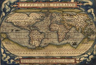
Theatrum Orbis Terrarum is considered to be the first true modern atlas. Written by Abraham Ortelius, strongly encouraged by Gillis Hooftman and originally printed on 20 May 1570 in Antwerp, it consisted of a collection of uniform map sheets and supporting text bound to form a book for which copper printing plates were specifically engraved. The Ortelius atlas is sometimes referred to as the summary of sixteenth-century cartography. The publication of the Theatrum Orbis Terrarum (1570) is often considered as the official beginning of the Golden Age of Netherlandish cartography.

The Rupes Nigra was a theorized black rock located at the Magnetic North Pole or at the North Pole itself. Described by Mercator as 33 "French" miles in size, it provided a supposed explanation for why all compasses point to this location. This fact came from a lost work titled Inventio Fortunata, and the island featured on maps from the sixteenth and seventeenth centuries, including those of Gerardus Mercator and his successors. Mercator described the island in a 1577 letter to John Dee:
In the midst of the four countries is a Whirl-pool, into which there empty these four indrawing Seas which divide the North. And the water rushes round and descends into the Earth just as if one were pouring it through a filter funnel. It is four degrees wide on every side of the Pole, that is to say eight degrees altogether. Except that right under the Pole there lies a bare Rock in the midst of the Sea. Its circumference is almost 33 French miles, and it is all of magnetic Stone [Jacobus Cnoyen] years ago.

Gemma Frisius was a Dutch physician, mathematician, cartographer, philosopher, and instrument maker. He created important globes, improved the mathematical instruments of his day and applied mathematics in new ways to surveying and navigation. Gemma's rings, an astronomical instrument, are named after him. Along with Gerardus Mercator and Abraham Ortelius, Frisius is often considered one of the founders of the Netherlandish school of cartography, and significantly helped lay the foundations for the school's golden age.

Alpha Cassiopeiae or α Cassiopeiae, also named Schedar, is a second-magnitude star in the northern constellation of Cassiopeia. Though listed as the "alpha star" by Johann Bayer, α Cas's visual brightness closely matches the 'beta' (β) star in the constellation and it may appear marginally brighter or dimmer, depending on which passband is used. However, recent calculations from NASA's WISE telescope confirm that α Cas is the brightest in Cassiopeia, with an apparent magnitude of 2.240. Its absolute magnitude is 18 times greater than β Cas, and it is located over four times farther away from the Sun.

Rumold Mercator was a cartographer and the son of cartographer Gerardus Mercator.

The sinusoidal projection is a pseudocylindrical equal-area map projection, sometimes called the Sanson–Flamsteed or the Mercator equal-area projection. Jean Cossin of Dieppe was one of the first mapmakers to use the sinusoidal, appearing in a world map of 1570.

Mercator is a steel-hulled barquentine built in 1932 as a training ship for the Belgian merchant fleet. She was named after Gerardus Mercator (1512–1594), a Belgian cartographer. She was designed by G.L. Watson & Co. and built in Leith, Scotland and launched in 1932.

Gangelt is a municipality in the district of Heinsberg, in North Rhine-Westphalia, Germany. It is on the border with the Netherlands and about 10 km east of Sittard and 10 km south-west of Heinsberg.
Events from the year 1569 in art.

Josephus Gerardus Dominicus "Sef" Vergoossen is a former Dutch football manager.
The year 1569 in science and technology included a number of events, some of which are listed here.

The Mercator world map of 1569 is titled Nova et Aucta Orbis Terrae Descriptio ad Usum Navigantium Emendate Accommodata. The title shows that Gerardus Mercator aimed to present contemporary knowledge of the geography of the world and at the same time 'correct' the chart to be more useful to sailors. This 'correction', whereby constant bearing sailing courses on the sphere are mapped to straight lines on the plane map, characterizes the Mercator projection. While the map's geography has been superseded by modern knowledge, its projection proved to be one of the most significant advances in the history of cartography, inspiring the 19th century map historian Adolf Nordenskiöld to write "The master of Rupelmonde stands unsurpassed in the history of cartography since the time of Ptolemy." The projection heralded a new era in the evolution of navigation maps and charts and it is still their basis.

Gaspard van der Heyden was a goldsmith, engraver, master printer and builder of precision astronomical instruments including terrestrial and celestial globes from Leuven, Belgium. He was well known among the humanists in Leuven as well as among scientists and mathematicians.
Gerardus is a Latinized version of the Germanic name Gerard. It has been in use as a birth name in the Low Countries. In daily life, most people use a shorter version, such as Geert, Ger, Gerard, Gerd, Gerhard, Gerrie, Gerrit, Gert, and Geurt. Among people with this name are:

Arnold or Arnoldus Mercator was a Southern Netherlandish cartographer, mathematician and classical philologist. He was the eldest son of cartographer Gerardus Mercator and a brother of Rumold Mercator.


