
The East Bay Regional Park District (EBRPD) is a special district operating in Alameda County and Contra Costa County, California, within the East Bay area of the San Francisco Bay Area. It maintains and operates a system of regional parks which is the largest urban regional park district in the United States. The administrative office is located in Oakland.

Three Rivers Park District is a special park district serving the suburban areas of the Twin Cities including suburban Hennepin, Carver, Dakota, Scott, and Ramsey counties. Three Rivers's mission is "To promote environmental stewardship through recreation and education in a natural resources-based park system." Three Rivers operates twenty parks and ten regional trails, with at least two more regional trails planned. Nearly seven million people visit Three Rivers facilities each year. It has over 27,000 acres (11,000 ha) of parks and trails.

Rensselaer Lake is an artificial lake in Albany, New York, United States named for Major-General Stephen Van Rensselaer, last patroon of Rensselaerswyck. The lake was Albany's first municipally-owned source of water. It is part of a 57-acre (23 ha) park and the state's Albany Pine Bush Preserve. The lake and park have been under the purview of the Albany Water Authority since 2003.
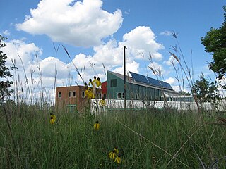
The Minnesota Valley National Wildlife Refuge is a 14,000-acre (5,666 ha) National Wildlife Refuge in eastern and central Minnesota. Located just south of the city of Minneapolis, it is one of fourteen Regional Priority Urban Wildlife Refuges in the nation. Many parts of the Refuge are near large establishments of the Twin Cities; the Bloomington Education and Visitor Center and two trailheads are located just blocks from the Mall of America, the Wilkie Unit is just east of Valleyfair and the Louisville Swamp Unit is just south of Minnesota Renaissance Festival.

Marsh Creek State Park is a 1,705 acres (690 ha) Pennsylvania state park in Upper Uwchlan and Wallace Townships, Chester County, Pennsylvania in the United States. The park is the location of the 535-acre (217 ha) man-made Marsh Creek Lake. With an average depth of 40 feet, the lake is stocked with fish and is a stop for migrating waterfowl. Marsh Creek State Park is 2 miles (3.2 km) west of Eagle on Pennsylvania Route 100. Park road hours 8:00 am until sunset. All other access open 24 hours.

Rancho San Antonio County Park and Rancho San Antonio Open Space Preserve are a conjoined public recreational area in the Santa Cruz Mountains, in the northwest quadrant of Santa Clara County, California. The County Park is bordered by Los Altos with some parts of the eastern part of the County Park in western Cupertino. The Open Space Preserve is on the west side of the County Park, also bordered by Los Altos Hills, Monte Bello Open Space Preserve, and the Permanente Quarry.
Round Valley Regional Preserve is a regional park just outside Antioch, CA and Brentwood, CA that is part of the East Bay Regional Parks (EBRPD) system. It is on Marsh Creek Road, approximately 5.2 miles (8.4 km) west of the intersection with Vasco Road. The park was begun in 1988, when Jim Murphy sold 700 acres (280 ha) of land to EBRPD. The land originally belonged to Mr. Davis' grandfather Thomas Murphy, an Irish immigrant, who had purchased the land in 1878 for a farming and ranching operation. The preserve has since expanded to encompass 1,911 acres (773 ha).
Bothin Marsh is a 106 acres (43 ha) wetland in Marin County, California. Parts of the wetlands are in the Bothin Marsh Open Space Preserve, a regional park.

Novato Creek is a stream in eastern Marin County, California, United States. It originates in highlands between Red Hill and Mount Burdell above the city of Novato, California, and flows 17 miles (27 km) before emptying into San Pablo Bay south of Petaluma Point.
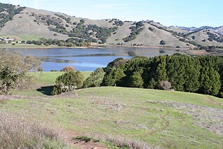
Stafford Lake County Park is a park in the Marin County, California parks system, managed by the Marin County Department of Parks and Open Space. The 139 acres (0.56 km2) park is located in Novato, 33 miles (53 km) north of San Francisco California and is in a classic northern California valley among grazing farmland.
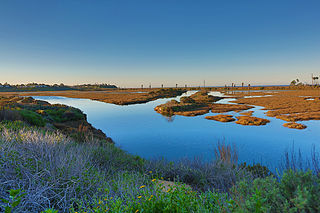
San Elijo Lagoon Ecological Reserve is one of the largest remaining coastal wetlands in San Diego County, California, United States.

Adobe Creek, historically San Antonio Creek, is a 14.2-mile-long (22.9 km) northward-flowing stream originating on Black Mountain in the Santa Cruz Mountains. It courses through the cities of Los Altos Hills, Los Altos, and Palo Alto on its way to the Palo Alto Flood Basin and thence to southwestern San Francisco Bay in Santa Clara County, California, United States. Historically, Adobe Creek was a perennial stream and hosted runs of steelhead trout entering from the Bay, but these salmonids are now blocked by numerous flood control structures, including a tidal gate at the creek's mouth and a long concretized rectangular channel culminating in an impassable drop structure at El Camino Real. The co-founders of Adobe Systems both lived on Adobe Creek.
Rush Creek is a stream in eastern Marin County, California, United States. It originates on the north edge of Novato, California and flows 1.5 miles (2.4 km) northeasterly through wetlands into Black John Slough and then the Petaluma River. The name is associated with Peter Rush who bought land near Novato in 1862.
Martin Creek, known locally as Dennis Martin Creek, is a 1.4-mile-long (2.3 km) north by northeastward-flowing stream originating just east of Skyline Boulevard in the Santa Cruz Mountains, near the community of Skylonda in San Mateo County, California. It flows through the town of Woodside before crossing Portola Road and joining Sausal Creek on Stanford University lands just across the border from Woodside. Sausal Creek enters Searsville Reservoir, which flows to San Francisco Bay via San Francisquito Creek.

Alamitos Creek or Los Alamitos Creek is a 7.7-mile-long (12.4 km) creek in San Jose, California, which becomes the Guadalupe River when it exits Lake Almaden and joins Guadalupe Creek. Los Alamitos Creek is located in Almaden Valley and originates from the Los Capitancillos Ridge in the Santa Cruz Mountains, near New Almaden. This creek flows through the Valley's Guadalupe Watershed, which is owned by the Santa Clara Valley Water District. The creek flows in a generally northwesterly direction after rounding the Los Capitancillos Ridge and the town of New Almaden, in the southwest corner, before ambling along the Santa Teresa Hills on northeast side of the Almaden Valley. Its environment has some relatively undisturbed areas and considerable lengths of suburban residential character. Originally called Arroyo de los Alamitos, the creek's name is derived from "little poplar", "alamo" being the Spanish word for "poplar" or "cottonwood".

Arroyo Conejo Open Space is a 302-acre (122 ha) open space reserve in the western Simi Hills in northern Newbury Park, Ventura County, California. Most of it is part of the 250-acre (100 ha) Arroyo Conejo Nature Preserve.

The Tifft Nature Preserve is a 264-acre nature preserve in Buffalo, New York, and one of the largest municipal nature preserves in New York.

Big Rock Ridge is a ridge near Novato, California, and the 2nd tallest point in Marin County. The ridge is 5 miles long, and runs from the northwest to the east, dividing Novato's Ignacio Valley and San Rafael's Lucas Valley, and separating Novato from central and southern Marin County. Big Rock Ridge is named after the rock at the base of Big Rock Trail.

The Vince Mulroy Memorial Woodland and Wildlife Preserve, formerly known as the Black Point Nature Preserve, is a 64-acre parcel of public land in Novato, California with various hiking trails. The preserve is also partially on the site of the former Renaissance Pleasure Faire, which took place there from 1971 until 1998. When the faire went bankrupt, Vince Mulroy bought the land and donated part of it to become the preserve, with the other part becoming the Stonetree Golf Club. In 2009, the preserve changed names from the Black Point Nature Preserve to the Vince Mulroy Memorial Woodland and Wildlife Preserve.


