This article relies largely or entirely on a single source .(April 2013) |
Rush Green is a hamlet on the outskirts of Hertford , Hertfordshire. The Roman road Ermine Street passed through Rush Green. [1]
This article relies largely or entirely on a single source .(April 2013) |
Rush Green is a hamlet on the outskirts of Hertford , Hertfordshire. The Roman road Ermine Street passed through Rush Green. [1]
It is next to the Foxholes and Pinehurst housing estates, and bridges the gap between Hertford Heath and Hertford.
The A10 road passes by, and is connected by the Rush Green roundabout.
Since the closure of McDonald's in Hertford Town Centre, Rush Green now contains the only McDonald's in Hertford.[ clarification needed ]

Snow Shoe Township is a township in Centre County, Pennsylvania, United States. It is part of the State College, Pennsylvania Metropolitan Statistical Area. The population was 1,746 at the 2010 census.

Hubbard is a city in Hill County, Texas, United States. It was named for Texas Governor Richard B. Hubbard. The city is 72 miles (116 km) by road south of Dallas. The population was 1,423 at the 2010 census, down from 1,586 at the 2000 census.
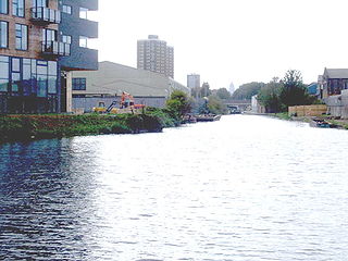
The Hertford Union Canal or Duckett's Cut is just over 1 mile (1.6 km) long in the London Borough of Tower Hamlets in East London. It connects the Regent's Canal to the Lee Navigation. It was opened in 1830 but quickly proved to be a commercial failure. It was acquired by the Regents Canal Company in 1857, and became part of the Grand Union Canal in 1927.

East Hertfordshire is a local government district in Hertfordshire, England. Its council is based in Hertford, the county town of Hertfordshire. The largest town in the district is Bishop's Stortford, and the other main towns are Ware, Buntingford and Sawbridgeworth. At the 2011 Census, the population of the district was 137,687.

Cheshunt is a town in the Borough of Broxbourne, Hertfordshire, lying entirely within the London Metropolitan Area and Greater London Urban Area. The area is on the River Lea, Lee Navigation together with the New River.

The A414 is a major road in England. It runs from the A41 at a junction west of Hemel Hempstead in Hertfordshire, through the town to junction 8 of the M1 motorway at Buncefield, and running parallel to the M1 until junction 7, heading south of St Albans, east through Hatfield, Hertford, then across the A10 and into Essex through Harlow, Chipping Ongar and Chelmsford before terminating at Maldon.

The Greenbelt is a 203.5-square-kilometre (78.6 sq mi) protected green belt traversing Ottawa, Ontario, Canada. It includes green space, forests, farms, and wetlands from Shirleys Bay in the west and to Green's Creek in the east. The National Capital Commission (NCC) owns and manages 149.5 square kilometres (57.7 sq mi), and the rest is held by other federal government departments and private interests. Real estate development within the Greenbelt is strictly controlled.

Bushey is a town in the Hertsmere borough of Hertfordshire in the East of England. It has a population of over 25,000 inhabitants. Bushey Heath is a large neighbourhood south east of Bushey on the boundary with the London Borough of Harrow reaching elevations of 165 metres (541 ft) above sea level.

Abbots Langley is a large village and civil parish in the English county of Hertfordshire. It is an old settlement and is mentioned in the Domesday Book. Economically the village is closely linked to Watford and was formerly part of the Watford Rural District. Since 1974 it has been included in the Three Rivers district.

The A105 road is an A road in London, England. It runs from Canonbury, in between Highbury and Dalston, to Enfield Town. The road is 8 miles (13 km) long. Part of the road forms Green Lanes, one of the longest streets in London, while the A105 also serves as the primary access route to the Shopping City shopping centre.
The A307 road runs 13.2 miles (21.2 km) through SW London and NW Surrey. It is primary at the north-east end; the remainder is non-primary, generally superseded in the mid-twentieth century in two stages by newer alignments of the Portsmouth Road, the Kingston bypass and Esher bypass of the A3, which runs along a slightly oblique axis.

Old Gorhambury House located near St Albans, Hertfordshire, England, is a ruined Elizabethan mansion, a leading and early example of the Elizabethan prodigy house. It was built in 1563–68 by Sir Nicholas Bacon, Lord Keeper, and was visited a number of times by Queen Elizabeth. It is a Grade I listed building.
The A602 is a road linking Hitchin in Hertfordshire, England, with A10 at Ware in Hertfordshire, via Stevenage.

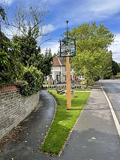
Hertford Heath is a village and civil parish near the county town of Hertford in Hertfordshire, England. The population at the 2011 Census was 2,672.

Lakeview Estate is a housing estate in Old Ford, east London designed by Berthold Lubetkin. It was built on a site damaged by bombing in World War II, on Grove Road between Old Ford Road and the Hertford Union Canal. The estate opened in 1958. It overlooks the lake in Victoria Park.

The Lea Valley Walk is a 50-mile (80 km) long-distance path located between Leagrave, the source of the River Lea near Luton, and the Thames, at Limehouse Basin, Limehouse, east London. From its source much of the walk is rural. At Hertford the path follows the towpath of the River Lee Navigation, and it becomes increasingly urbanised as it approaches London. The walk was opened in 1993 and is waymarked throughout using a swan logo.
Hertingfordbury is a small village in Hertfordshire, England, close to the county town of Hertford. It was mentioned in the Domesday Book. Hertingfordbury is also the name of a neighbouring civil parish, which does not contain the village, which is actually within the local government area of Hertford Town Council. The population of the civil parish as of the 2011 census is 630.
Kiousville is an unincorporated community in southern Fairfield Township, Madison County, Ohio, United States. It is located at 39°47′50″N83°17′41″W, at the intersection of Kiousville-Georgesville Road and McKendree Road.

51.5976°N 0.0704°W

Twickenham Park was an estate in Twickenham in south-west London.
Coordinates: 51°47′50″N0°02′30″W / 51.79722°N 0.04167°W
| | This Hertfordshire location article is a stub. You can help Wikipedia by expanding it. |