
The Hanseatic League was a medieval commercial and defensive confederation of merchant guilds and market towns in Central and Northern Europe. Growing from a few North German towns in the late 12th century, the League expanded between the 13th and 15th centuries and ultimately encompassed nearly 200 settlements across seven modern-day countries, ranging from Estonia in the north and east, to the King's Lynn, England in the west, and Kraków, Poland, in the south.
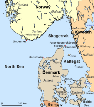
The Kattegat is a 30,000 km2 (12,000 sq mi) sea area bounded by the Jutlandic peninsula in the west, the Danish Straits islands of Denmark and the Baltic Sea to the south and the provinces of Bohuslän, Västergötland, Halland and Skåne in Sweden in the east. The Baltic Sea drains into the Kattegat through the Danish Straits. The sea area is a continuation of the Skagerrak and may be seen as a bay of the North Sea, but in traditional Scandinavian usage, this is not the case.

The Wash is a rectangular bay and multiple estuary at the north-west corner of East Anglia on the East coast of England, where Norfolk meets Lincolnshire and both border the North Sea. One of Britain's broadest estuaries, it is fed by the rivers Witham, Welland, Nene and Great Ouse. It is a 620 km² biological Site of Special Scientific Interest. It is also a Nature Conservation Review site, Grade I, a National Nature Reserve, a Ramsar site, a Special Area of Conservation and a Special Protection Area. It is in the Norfolk Coast Area of Outstanding Natural Beauty and part of it is the Snettisham Royal Society for the Protection of Birds nature reserve.
The Old Salt Route was a medieval trade route in Northern Germany, one of the ancient network of salt roads which were used primarily for the transport of salt and other staples. In Germany it was referred to as Alte Salzstraße.

Stralsund, officially the Hanseatic City of Stralsund, is the fifth-largest city in the northeastern German federal state of Mecklenburg-Western Pomerania after Rostock, Schwerin, Neubrandenburg and Greifswald, and the second-largest city in the Pomeranian part of the state. It is located on the southern coast of the Strelasund, a sound of the Baltic Sea separating the island of Rügen from the Pomeranian mainland.
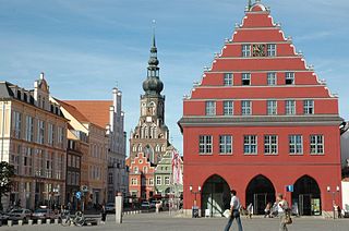
Greifswald, officially the University and Hanseatic City of Greifswald is the fourth-largest city in the German state of Mecklenburg-Western Pomerania after Rostock, Schwerin and Neubrandenburg. In 2021 it surpassed Stralsund for the first time, and became the largest city in the Pomeranian part of the state. It sits on the River Ryck, at its mouth into the Danish Wiek, a sub-bay of the Bay of Greifswald, which is itself a sub-bay of the Bay of Pomerania of the Baltic Sea.

The Arthur Kill is a tidal strait in the New York–New Jersey Harbor Estuary between Staten Island, New York and Union and Middlesex counties, New Jersey. It is a major navigational channel of the Port of New York and New Jersey.

The Bay of Pomerania is a basin in the southwestern Baltic Sea, off the Pomeranian shores of Poland and Germany. It stretches between the northernmost tip of the island of Rugia called Gellort northwest of Cape Arkona in the west, and the village of Jarosławiec in the east. In the south, it is bounded by the islands of Usedom/Uznam and Wolin, which separate it from the Szczecin Lagoon which is flown through by the Oder River, and is connected to the bay by three straits, the Dziwna, Świna, and Peenestrom.

The Bay of Greifswald or Greifswald Bodden is a basin in the southwestern Baltic Sea, off the shores of Germany in the state of Mecklenburg-Vorpommern. With an area of 514 km², it is the largest Bodden of the German Baltic coast.

Louisiana Highway 1 (LA 1) is a state highway in Louisiana. At 431.88 miles (695.04 km), it is the longest numbered highway of any class in Louisiana. It runs diagonally across the state, connecting the oil and gas fields near the island of Grand Isle with the northwest corner of the state, north of Shreveport.
The Wiese is a river, 57.8 kilometres long, and a right-hand tributary of the Rhine in southwest Germany and northwest Switzerland.

The Flushing River, also known as Flushing Creek, is a waterway that flows northward through the borough of Queens in New York City, mostly within Flushing Meadows–Corona Park, emptying into the Flushing Bay and the East River. The river runs through a valley that may have been a larger riverbed before the last Ice Age, and it divides Queens into western and eastern halves. Until the 20th century, the Flushing Creek was fed by three tributaries: Mill Creek and Kissena Creek on the eastern bank, and Horse Brook on the western bank.

A salt road refers to any of the prehistoric and historical trade routes by which essential salt was transported to regions that lacked it.

Casimir II was the duke of Pomerania-Demmin from 1187 until his death. He was succeeded by Wartislaw III, Casimir's son with princess Ingardis of Denmark.

Eldena Abbey, originally Hilda Abbey is a former Cistercian monastery near the present town of Greifswald in Mecklenburg-Vorpommern, Germany. Only ruins survive, which are well known as a frequent subject of Caspar David Friedrich's paintings, including the famous Abtei im Eichwald.

The E11 European long distance path or E11 path is one of the European long-distance paths, running 4700 km west-east from The Hague in the Netherlands through Germany, Poland, Lithuania, Latvia to Tallinn, Estonia. It starts in Scheveningen, a fishing community, commercial harbor and spa in The Hague on the Dutch coast of the North Sea. It ends in Tallinn, a medieval Hanseatic town situated side by side with the 21st century city of modern glass buildings, located on the shore of the Gulf of Finland of the Baltic Sea.

The Leine-Heide Cycle Path is a long-distance cycle path in Germany that has a total length of 410 kilometres (250 mi) and runs through the German federal states of Thuringia, Lower Saxony and Hamburg. Until 2009, it was called the Leine Cycle Path, after the River Leine; it ended north of the river's confluence with the Aller in Hodenhagen. Heide (‘heath’) refers to the Lüneburg Heath.

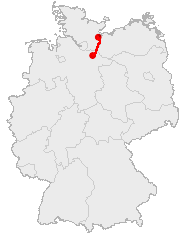
The Angermünde–Stralsund railway is a major railway in the north-eastern German states of Brandenburg and Mecklenburg-Vorpommern, which is part of the long-distance line from Berlin to Rügen. The line is one of the oldest lines in Western Pomerania and was built and operated by the Berlin-Stettin Railway Company from 1863.
Vitslav II, variously called Vislav, Vizlav, Wislaw, Wizlaw and Witslaw in English sources was a prince of Rügen.

Historical Western Pomerania, also called Cispomerania,Fore Pomerania, Front Pomerania or Hither Pomerania, is the western extremity of the historic region of Pomerania forming the southern coast of the Baltic Sea. Western Pomerania's boundaries have changed through the centuries as it belonged to various countries such as Poland, the Duchy of Pomerania, Sweden, Denmark, as well as Prussia which incorporated it as the Province of Pomerania.
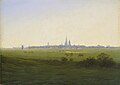 "Meadows near Greifswald" Caspar David Friedrich, 1820 (depicting the area used for salt evaporation)
 Old port, downtown Greifswald, view from Steinbecker bridge
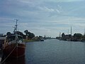 Old port, downtown Greifswald, view from pedestrians' bridge
 Old bridge in Greifswald-Wieck
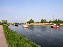
 Mouth at Greifswald-Wieck
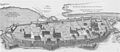 Map of medieval Greifswald showing Boltenhäg(en)er Teich and the confluence of the Baberow, neither of which now exist.


