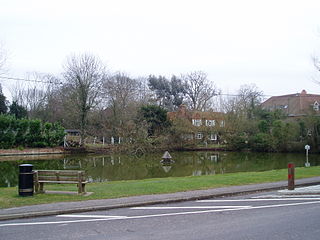
Odiham is a large historic village and civil parish in the Hart district of Hampshire, England. It is twinned with Sourdeval in the Manche Department of France. The 2011 population was 4,406. The parish in 1851 had an area of 7,354 acres with 50 acres covered by water. The nearest railway station is at Hook, on the South West main line. The village had its own hundred, named The Hundred of Odiham. The village is situated slightly south of the M3 motorway and approximately midway between the north Hampshire towns of Fleet and Basingstoke, some 37 miles north-northeast of Southampton and 43 miles (69 km) southwest of London.

Hartley Wintney is a large village and civil parish in the Hart district of Hampshire, England. It lies about 3 miles (5 km) northwest of Fleet and 8 miles (13 km) east of Basingstoke. The parish includes the smaller contiguous village of Phoenix Green as well as the hamlets of Dipley, Elvetham, Hartfordbridge, and West Green.
Hook is a large village and civil parish in the Hart District of northern Hampshire, England.

Sherfield on Loddon—formerly Sherfield upon Loddon—is a village and civil parish in the English county of Hampshire. It is located at grid reference SU680580, approximately 12 miles (19 km) south of Reading and 6 miles (10 km) north of Basingstoke.

Bentworth is a village and civil parish in the East Hampshire district of Hampshire, England. The nearest town is Alton, which lies about 3 miles (5 km) east of the village. It sits within the East Hampshire Hangers, an area of rolling valleys and high downland. The parish covers an area of 3,763 acres (15.23 km2) and at its highest point is the prominent King's Hill, 716 feet (218 m) above sea level. According to the 2011 census, Bentworth had a population of 553.

Joppa is a former hamlet in South Ayrshire, Scotland, about one mile which now forms the eastern portion of the built-up part of Coylton, situated about one mile east of Belston, on the A70 road.

Ben More Assynt is a mountain in Assynt in the far north-west of Scotland, 30 kilometres north-northeast of Ullapool. The name translates as "big mountain of Assynt", and with a height of 998 metres it is the highest point in Sutherland.
North Warnborough is a village in the Hart district of Hampshire, England. It is in the civil parish of Odiham. It is located less than 2 miles (3.2 km) south of the town of Hook, on the opposite side of the M3 motorway, and just north-west of the village of Odiham. The Basingstoke Canal passes through the village, and the River Whitewater flows to the north.
Ockle is a remote hamlet, situated on the northcoast of the Ardnamurchan peninsula, Scottish Highlands and is in the Scottish council area of Highland.

Well is a small village and civil parish in the Hart district of Hampshire, England. It is in the civil parish of Long Sutton. The village lies approximately 3.1 miles (5.0 km) south-east from Odiham. It is adjacent to Lord Wandsworth College. The local pub is called The Chequers Inn.

Waterloo is a small hamlet in Perth and Kinross, Scotland approximately 1⁄2 mile north of Bankfoot on the old A9.

Weston Patrick is a small village and civil parish in Hampshire. It lies four miles (6 km) southeast from Basingstoke and covers an area of 1,183 acres (4.79 km2). Weston Patrick is divided from the neighbouring parish of Weston Corbett by the road leading to the village of Upton Grey.

Weston Corbett is a hamlet and civil parish in Hampshire and lies three miles south from Basingstoke. There is only one mention of Weston Corbett in the Domesday Survey of 1086. The first reference to Weston Corbett occurs in 1224, when the land belonged to the Crown and was held by Thomas Corbett. Although the Corbett family gave their name to the parish, the land at Weston Corbett has subsequently changed hands many times.
Blounce is a small hamlet in the civil parish of South Warnborough in the Hart district of Hampshire, England. It lies on the B3349 road in between Alton and Odiham. The hamlet is only made up of a few cottages and was once a main crossing point between Alton and Odiham.
Mill Lane is a hamlet in Hampshire, England. Its nearest town is Fleet approximately 2.5 miles away. The hamlet lies on the A287 road between Odiham and Aldershot. The hamlet is only made up of a few houses and a petrol station.
Warnborough Green is a village in the civil parish of Odiham in Hampshire, England. It lies approximately 1 mile (1.75 km) north-east from Odiham.
Whitehall is a hamlet in the civil parish of Odiham in Hampshire, England. Its nearest town is Hook, approximately 3.5 miles (4.75 km) away.
Dora's Green is a hamlet in the Hart District of Hampshire, England. The hamlet lies near the A287 road between Farnham and Odiham on the Hampshire-Surrey border. Its nearest town is Farnham, approximately 2 miles (3 km) south-east.

Carnbo is a hamlet in Perth and Kinross, Scotland. It lies approximately 6 miles west of Kinross, on the A91 road on the South Queich burn.

Middleton is a hamlet and farmstead in Perth and Kinross, Scotland. It lies approximately 3 miles north of Kinross, to the west of the M90 motorway.


