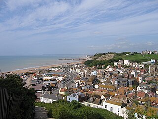
Hastings is a seaside town and borough in East Sussex on the south coast of England, 24 mi (39 km) east of Lewes and 53 mi (85 km) south east of London. The town gives its name to the Battle of Hastings, which took place 8 mi (13 km) to the north-west at Senlac Hill in 1066. It later became one of the medieval Cinque Ports. In the 19th century, it was a popular seaside resort, as the railway allowed tourists and visitors to reach the town. Today, Hastings is a popular seaside resort and is still a fishing port with the UK's largest beach-based fishing fleet. Its estimated population was 91,100 in 2021.

Sandwich is a town and civil parish in the Dover District of Kent, south-east England. It lies on the River Stour and has a population of 4,985. Sandwich was one of the Cinque Ports and still has many original medieval buildings, including several listed public houses and gates in the old town walls, churches, almshouses and the White Mill. While once a major port, it is now 2 miles (3 km) from the sea due to the disappearance of the Wantsum Channel. Its historic centre has been preserved. Sandwich Bay is home to nature reserves and two world-class golf courses, Royal St George's and Prince's. The town is also home to many educational and cultural events. Sandwich also gave its name to the food by way of John Montagu, 4th Earl of Sandwich, and the word sandwich is now found in several languages.

Chester Castle is in the city of Chester, Cheshire, England. It is sited at the southwest extremity of the area bounded by the city walls. The castle stands on an eminence overlooking the River Dee. In the castle complex are the remaining parts of the medieval castle together with the neoclassical buildings designed by Thomas Harrison which were built between 1788 and 1813. Parts of the neoclassical buildings are used today by the Crown Court and as a military museum. The museum and the medieval remains are a tourist attraction.
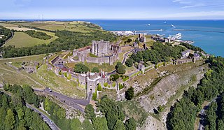
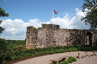
Dover Castle is a medieval castle in Dover, Kent, England and is Grade I listed. It was founded in the 11th century and has been described as the "Key to England" due to its defensive significance throughout history. Some writers say it is the largest castle in England, a title also claimed by Windsor Castle.

Pevensey is a village and civil parish in the Wealden district of East Sussex, England. The main village is located five miles (8 km) north-east of Eastbourne, one mile (1.6 km) inland from Pevensey Bay. The settlement of Pevensey Bay forms part of the parish. It was here that William the Conqueror made the landing in his invasion of England in 1066 after crossing the English Channel from Normandy.

Rye is a town and civil parish in the Rother district of East Sussex, England, two miles from the sea at the confluence of three rivers: the Rother, the Tillingham and the Brede. An important member of the mediaeval Cinque Ports confederation, it was at the head of an embayment of the English Channel, and almost entirely surrounded by the sea.

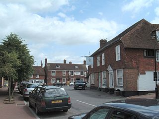
Devizes is a market town and civil parish in Wiltshire, England. It developed around Devizes Castle, an 11th-century Norman castle, and received a charter in 1141. The castle was besieged during the Anarchy, a 12th-century civil war between Stephen of England and Empress Matilda, and again during the English Civil War when the Cavaliers lifted the siege at the Battle of Roundway Down and the Parliamentarian Army of the West under Sir William Waller was routed. Devizes remained under Royalist control until 1645, when Oliver Cromwell attacked and forced the Royalists to surrender. The castle was destroyed in 1648 on the orders of Parliament, and today little remains of it.
Rotherfield is a village and civil parish in the Wealden District of East Sussex, England. It is one of the largest parishes in East Sussex. There are three villages in the parish: Rotherfield, Mark Cross and Eridge. The River Rother, which drains much of the county and discharges at Rye Harbour, has its source on the south side of the hill on which Rotherfield village is built.
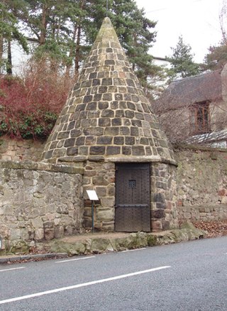
A village lock-up is a historic building once used for the temporary detention of people in England and Wales, mostly where official prisons or criminal courts were beyond easy walking distance. Lockups were often used for the confinement of drunks, who were usually released the next day, or to hold people being brought before the local magistrate. The archetypal form comprises a small room with a single door and a narrow slit window, grating or holes. Most lock-ups feature a tiled or stone-built dome or spire as a roof and are built from brick, stone and/or timber.
Monmouth Castle is a castle close to the centre of the town of Monmouth, the county town of Monmouthshire, on a hill above the River Monnow in south-east Wales.
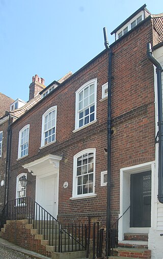
Rye Particular Baptist Chapel is a former Strict Baptist place of worship in Rye, an ancient hilltop town in Rother, one of six local government districts in the English county of East Sussex. Built in the 18th century on the site of a decaying Quaker meeting house, it served Baptists in the town for many years until a new chapel was constructed nearby. The chapel is a Grade II Listed building.

St Mary Magdalene's Church is a Greek Orthodox place of worship in St Leonards-on-Sea, a town and seaside resort which is part of the Borough of Hastings in East Sussex, England. Dedicated to Mary Magdalene and built in 1852 for Anglican worshippers in the growing new town of St Leonards-on-Sea, a seaside resort which had been laid out from the 1820s, the church's prominent position on the skyline overlooking the town was enhanced in 1872 by the addition of a tower. No longer required by the Anglican community in the 1980s, it was quickly bought by the Greek Orthodox Church and converted into a place of worship in accordance with their requirements. The alterations were minimal, though, and the building retains many of its original fittings and its "archaeologically correct Gothic" exterior which reflected architectural norms of the early Victorian era. English Heritage has listed the church at Grade II for its architectural and historical importance.

The Mermaid Inn is a Grade II* listed historical inn located on Mermaid Street in the ancient town of Rye, East Sussex, southeastern England. One of the best-known inns in southeast England, it was established in the 12th century and has a long, turbulent history. The current building dates from 1420 and has 16th-century additions in the Tudor style, but cellars built in 1156 survive. The inn has a strong connection with the notorious Hawkhurst Gang of smugglers, who used it in the 1730s and 1740s as one of their strongholds: Rye was a thriving port during this period. Some of the smugglers, their mistresses and other characters are reported to haunt the inn.

St Augustine's Church is a Grade I listed Anglican church in the village of Brookland, Kent, in Walland Marsh, about 5 miles (8.0 km) north-east of Rye, East Sussex. It was originally built about 1250. It has the unusual feature that the bell tower is separate from the rest of the church.

Glottenham Castle was a castle in Mountfield, East Sussex, around 5 miles (8 km) north of Battle Abbey. Built in the 13th century, it was abandoned in the late 16th or 17th century.

Barbican House is a sixteenth century house next to Lewes Castle. It is now used as a museum, and is the headquarters of the Sussex Archaeological Society. The house is a Grade II* listed building.
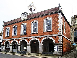
Rye Town Hall is a municipal building in Market Street, Rye, East Sussex, England. The building, which is the meeting place of Rye Town Council, is a Grade II* listed building.

Winchelsea Court Hall, formerly known as the Water Bailiff's Prison, is a municipal building in the High Street in Winchelsea, East Sussex, England. The structure, which is used as a museum, is a Grade I listed building.


