
The Global Positioning System (GPS), originally Navstar GPS, is a satellite-based radio navigation system owned by the United States government and operated by the United States Space Force. It is one of the global navigation satellite systems (GNSS) that provide geolocation and time information to a GPS receiver anywhere on or near the Earth where there is an unobstructed line of sight to four or more GPS satellites. It does not require the user to transmit any data, and operates independently of any telephone or Internet reception, though these technologies can enhance the usefulness of the GPS positioning information. It provides critical positioning capabilities to military, civil, and commercial users around the world. Although the United States government created, controls and maintains the GPS system, it is freely accessible to anyone with a GPS receiver.
Iridium Communications Inc. is a publicly traded American company headquartered in McLean, Virginia, United States. Iridium operates the Iridium satellite constellation, a system of 75 satellites: 66 are active satellites and the remaining nine function as in-orbit spares. Iridium Satellites are used for worldwide voice and data communication from handheld satellite phones, satellite messenger communication devices and integrated transceivers, as well as for two-way satellite messaging service from supported conventional mobile phones. The nearly polar orbit and communication between satellites via inter-satellite links provide global service availability.
Location-based service (LBS) is a general term denoting software services which use geographic data and information to provide services or information to users. LBS can be used in a variety of contexts, such as health, indoor object search, entertainment, work, personal life, etc. Commonly used examples of location-based services include navigation software, social networking services, location-based advertising, and tracking systems. LBS can also include mobile commerce when taking the form of coupons or advertising directed at customers based on their current location. LBS also includes personalized weather services and even location-based games.

An emergency position-indicating radiobeacon (EPIRB) is a type of emergency locator beacon for commercial and recreational boats, a portable, battery-powered radio transmitter used in emergencies to locate boaters in distress and in need of immediate rescue. In the event of an emergency, such as a ship sinking or medical emergency onboard, the transmitter is activated and begins transmitting a continuous 406 MHz distress radio signal, which is used by search-and-rescue teams to quickly locate the emergency and render aid. The signal is detected by satellites operated by an international consortium of rescue services, COSPAS-SARSAT, which can detect emergency beacons anywhere on Earth transmitting on the distress frequency of 406 MHz. The satellites calculate the position or utilize the GPS coordinates of the beacon and quickly passes the information to the appropriate local first responder organization, which performs the search and rescue. As Search and Rescue approach the search areas, they use Direction Finding (DF) equipment to locate the beacon using the 121.5 MHz homing signal, or in newer EPIRBs, the AIS location signal. The basic purpose of this system is to help rescuers find survivors within the so-called "golden day" during which the majority of survivors can usually be saved. The feature distinguishing a modern EPIRB, often called GPIRB, from other types of emergency beacon is that it contains a GPS receiver and broadcasts its position, usually accurate within 100 m (330 ft), to facilitate location. Previous emergency beacons without a GPS can only be localized to within 2 km (1.2 mi) by the COSPAS satellites and relied heavily upon the 121.5 MHz homing signal to pin-point the beacons location as they arrived on scene.

A pager, also known as a beeper or bleeper, is a wireless telecommunications device that receives and displays alphanumeric or voice messages. One-way pagers can only receive messages, while response pagers and two-way pagers can also acknowledge, reply to, and originate messages using an internal transmitter.
Globalstar, Inc. is an American satellite communications company that operates a low Earth orbit (LEO) satellite constellation for satellite phone, low-speed data communications and earth observations. The Globalstar second-generation constellation consists of 25 low Earth orbiting (LEO) satellites.
Messaging spam, sometimes called SPIM, is a type of spam targeting users of instant messaging (IM) services, SMS, or private messages within websites.

A satellite telephone, satellite phone or satphone is a type of mobile phone that connects to other phones or the telephone network by radio link through satellites orbiting the Earth instead of terrestrial cell sites, as cellphones do. Therefore, they can work in most geographic locations on the Earth's surface, as long as open sky and the line-of-sight between the phone and the satellite are provided. Depending on the architecture of a particular system, coverage may include the entire Earth or only specific regions. Satellite phones provide similar functionality to terrestrial mobile telephones; voice calling, text messaging, and low-bandwidth Internet access are supported through most systems. The advantage of a satellite phone is that it can be used in such regions where local terrestrial communication infrastructures, such as landline and cellular networks, are not available.
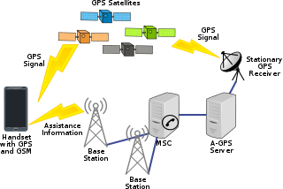
Assisted GNSS (A-GNSS) is a GNSS augmentation system that often significantly improves the startup performance—i.e., time-to-first-fix (TTFF)—of a global navigation satellite system (GNSS). A-GNSS works by providing the necessary data to the device via a radio network instead of the slow satellite link, essentially "warming up" the receiver for a fix. When applied to GPS, it is known as assisted GPS or augmented GPS. Other local names include A-GANSS for Galileo and A-Beidou for BeiDou.

The Broadband Global Area Network (BGAN) is a global satellite network with telephony owned by Inmarsat using portable terminals. The terminals are normally used to connect a laptop computer to broadband Internet in remote locations, although as long as line-of-sight to the satellite exists, the terminal can be used anywhere. The value of BGAN terminals is that, unlike other satellite Internet services, which require bulky and heavy satellite dishes to connect, a BGAN terminal is about the size of a laptop and thus can be carried easily. The network is provided by Inmarsat and uses three geostationary satellites called I-4 to provide almost global coverage.

The International Cospas-Sarsat Programme is a satellite-aided search and rescue (SAR) initiative. It is organized as a treaty-based, nonprofit, intergovernmental, humanitarian cooperative of 45 nations and agencies. It is dedicated to detecting and locating emergency locator radio beacons activated by persons, aircraft or vessels in distress, and forwarding this alert information to authorities that can take action for rescue. Member countries support the distribution of distress alerts using a constellation of around 65 satellites orbiting the Earth which carry transponders and signal processors capable of locating an emergency beacon anywhere on Earth transmitting on the Cospas-Sarsat frequency of 406 MHz.

ORBCOMM is an American company that offers industrial internet and machine to machine (M2M) communications hardware, software and services designed to track, monitor, and control fixed and mobile assets in markets including transportation, heavy equipment, maritime, oil and gas, utilities and government. The company provides hardware devices, modems, web applications, and data services delivered over multiple satellites and cellular networks.
A GPS tracking unit, geotracking unit, satellite tracking unit, or simply tracker is a navigation device normally on a vehicle, asset, person or animal that uses satellite navigation to determine its movement and determine its WGS84 UTM geographic position (geotracking) to determine its location. Satellite tracking devices may send special satellite signals that are processed by a receiver.

GPS Block III consists of the first ten GPS III satellites, which will be used to keep the Navstar Global Positioning System operational. Lockheed Martin designed, developed and manufactured the GPS III Non-Flight Satellite Testbed (GNST) and all ten Block III satellites. The first satellite in the series was launched in December 2018.

The Samsung SCH-u470, or Juke and Verizon Wireless Juke, is a mobile phone offered exclusively by Verizon Wireless. It was announced on 2 October 2007, and released that same year on Q4 in three colors: red, teal, and navy (blue). The phone is a music player when closed, and can be swiveled for use of the mobile phone. It also has a VGA-resolution camera with a special "night shot" mode for taking photos in low-light conditions.

A satellite navigation device, satnav device or satellite navigation receiver is a user equipment that uses one or more of several global navigation satellite systems (GNSS) to calculate the device's geographical position and provide navigational advice. Depending on the software used, the satnav device may display the position on a map, as geographic coordinates, or may offer routing directions.
A geofence is a virtual perimeter for a real-world geographic area. A geofence can be dynamically generated or match a predefined set of boundaries.
A Satellite Emergency Notification Device or SEND is a portable emergency notification and locating device which uses commercial satellite systems rather than the COSPAS-SARSAT satellite system. An example of this device is SPOT.
GPS aircraft tracking is a means of tracking the position of an aircraft fitted with a satellite navigation device. By communication with navigation satellites, detailed real-time data on flight variables can be passed to a server on the ground. This server stores the flight data, which can then be transmitted via telecommunications networks to organizations wishing to interpret it.
