Windward Islands Bovenwindse Eilanden (Dutch) | |
|---|---|
 | |
| Geography | |
| Location | Leeward Islands Lesser Antilles Caribbean Sea |
| Coordinates | 18°01′00″N63°02′00″W / 18.0167°N 63.0333°W |
| Total islands | 3 |
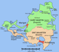
| Major islands | Saba Saint Martin Sint Eustatius |
| Demographics | |
| Population | ~85.000 (2025 estimate) |
| Languages | |
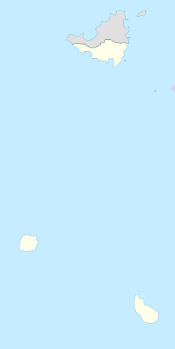
The SSS islands (Dutch : SSS-eilanden), locally also known as the Dutch Windward Islands (Bovenwindse Eilanden or Bovenwinden), is a collective term for the three territories of the Dutch Caribbean (formerly the Netherlands Antilles) that are located within the Leeward Islands group of the Lesser Antilles in the Caribbean Sea. [1] [2] [3] In order of population size, they are: Sint Maarten, Sint Eustatius, and Saba. In some contexts, the term is also used to refer to the entire island of Saint Martin (which also includes the Collectivity of Saint Martin), alongside Sint Eustatius and Saba.
Contents
The SSS islands were island territories of the Netherlands Antilles, until its dissolution in 2010. Since then, Sint Maarten is a constituent country of the Kingdom of the Netherlands, while Sint Eustatius and Saba are special municipalities of the Netherlands. "SSS" is an acronym of the islands' names, and is analogous to the ABC, CAS, and BES islands, which are other commonly used subdivisions of the Dutch Caribbean.