Sackville | |
---|---|
Motto: A different kind of small town | |
Coordinates: 45°53′53″N64°22′06″W / 45.89792°N 64.36834°W | |
Country | Canada |
Province | New Brunswick |
County | Westmorland |
Parish | Sackville Parish |
Town | Tantramar |
Established | 1762 |
Incorporated | January 4, 1903 (as Town of Sackville) |
Amalgamated | January 1, 2023 (into Town of Tantramar) |
Federal electoral district | Beauséjour |
Provincial electoral district | Memramcook-Tantramar |
Government | |
• MLA | Megan Mitton Green Party of New Brunswick |
• MP | Dominic LeBlanc (L) |
Area | |
• Land | 73.91 km2 (28.54 sq mi) |
Elevation | Sea level to 32 m (0 to 105 ft) |
Population (2021) [1] | |
• Total | 6,099 |
• Density | 82.5/km2 (214/sq mi) |
• Change (2016–21) | 14.4% |
Demonym | Sackvillian |
Time zone | UTC-4 (Atlantic (AST)) |
• Summer (DST) | UTC-3 (ADT) |
Canadian Postal code | E4L |
Area code | 506 |
Telephone Exchange | 360, 364, 536, 540, 939, 940 |
NTS Map | 21H16 Amherst |
GNBC Code | DAEAM |
Website | www |
Sackville is a former town in southeastern New Brunswick, Canada. It held town status prior to 2023 and is now part of the town of Tantramar.
Sackville is home to Mount Allison University, the top undergraduate liberal arts university in Canada. The university welcomes roughly 2200 students per academic year. [2] Historically based on agriculture, shipbuilding, and manufacturing, the economy is now driven by the university and tourism. Initially part of the French colony of Acadia, the settlement became part of the British colony of Nova Scotia in 1755 following the Expulsion of the Acadians.
Present-day Sackville is in the Mi’kmaq district of Siknikt (to which the place name Chignecto may be traced), which roughly comprised Cumberland, Westmorland and part of Albert counties. The Mi’kmaq settlement, Goesomaligeg, was on Fort Beausejour Ridge and Tatamalg or Tantama, on the Sackville Ridge. Many regional toponyms are Mi’kmaq including Tidnish, Minudie, Missaguash River, Aboushagan Road, Midgic, Memramcook and Shemogue. A portage connected Beaubassin by way of Westcock and the valley now known as Frosty Hollow with the Memramcook and Petitcodiac rivers and was an important link in the communications system between Acadia and Quebec. [3]
The first Acadians arrived in the early 1670s, as the French colony expanded from its base at Port Royal. Many of the Acadians came from the west of France and were experienced in reclaiming from the sea lowlands that might be made arable. The Tantramar Marshes were well suited to this, and the Acadians built a system of dykes and sluices that allowed them to cultivate the marshes. Surveyor Charles Morris visited in 1748, and reported Acadian settlements at Westcock; Pré des Bourgs, (Sackville); Pré des Richards, (Middle Sackville); Tintamare, (Upper Sackville); La Butte, Le Coup, Le Lac (Aulac); Portage, at the head of the Missaguash River; Beaubassin (adjacent to Beausejour); Jolicoeur, (Jolicure) and Pont à Buot, (Point de Bute). Farther afield, there were settlements at La Planche (Amherst) and Baie Verte for a total population of about 3,000. [4] Settlements were connected by trails and separated by marsh. A seaport at Westcock provided a link to Port Royal.
The Treaty of Utrecht in 1713 had ceded Acadia to England, but without specifying where the boundary was between Acadia and what remained of New France. This led to ongoing skirmishes until June 1755 when, as part of a wider struggle of the British and French of North American colonies, the French were defeated at the Battle of Beausejour. This led to the removal of most of the French military from Acadia. [5] Six weeks later, Governor Charles Lawrence, without distinguishing between neutral Acadians and those who had resisted the British, wrote that the Acadians "shall be removed out of the country as soon as possible, and as to those about the isthmus who were in arms and therefore entitled to no favour from the government it is determined to begin with them first". [6] This marked the beginning of the expulsion of the Acadians. They were only allowed to take with them their ready money and household furniture, and their buildings were burned to the ground.
Following the expulsion of the Acadians the British needed to repopulate the colony. The first wave of immigration was the New England Planters who were invited and encouraged with land grants. The Sackville area was abandoned for six years after the expulsion of the Acadians until 1761 when 25 families from Rhode Island settled on the vacated Acadian farms, followed in 1763 by a group of 13 from Swansea, Massachusetts, who formed the first Baptist church in Canada, but subsequently returned to New England. In 1763 the population was 20 families on 200 acres of cleared (probably by the Acadians) upland, and also marshlands. A 1767 census gives the population as 349, of which 343 were Americans. The Sackville Township, named after Viscount Sackville, was formally created in 1765 and by 1772 was sufficiently populated to send a representative to the Nova Scotia House of Assembly. [7]
The Yorkshire Emigration started in 1772 and lasted about three years. [8] They arrived too late to occupy the vacated Acadian farms which had already been granted to the New Englanders. However many New Englanders did not stay, and sold the land on to the British immigrants. [9]
When the American War of Independence broke out in 1775, many of the American settlers in the area were sympathetic with the Americans, and rebels led by Jonathan Eddy laid siege to Fort Cumberland. However the rebels were repelled by soldiers, with help from the Yorkshire settlers who remained loyal to the crown. [10] When the war was over, United Empire Loyalists, emigrated north, some to the Sackville area. [9] By 1786 there were 60 families in the township.
By the 1830s tanneries, leather goods factories, carriage factories and blacksmith shops were active around Morice Mill Pond (renamed recently to Silver Lake) a few kilometres north of the current town centre. The centre of activity started to shift to the present downtown area when in 1836 William Crane moved his business to the site of the former town hall, and built his house across the street. He also donated land for a small Methodist chapel that was built in 1838 and later evolved into the much larger Sackville Methodist/United Church. In 1839, Charles Frederick Allison donated money and land to establish the Mount Allison Wesleyan Academy, which became Mount Allison University. [11] This was followed by the development of shipyards on the Tantramar River. Official records for shipbuilding in New Brunswick began in 1824, but by that time shipbuilding was already well under way with several ships of over 100 tons having been built. [12]
In 1862 there was a shipyard at the site of the current railway station, and another to the east at Dixon's Landing at the end of Landing Road. A public wharf was built there by local merchants in 1840–41. The shopkeepers were looking to import products and export staples such as lumber, grindstones and building stones. In the 1870s, a spur line connecting the Intercolonial Railway to the wharf was built. [13]
Shipbuilding and coastal trading thrived between 1824 and 1872. The last was built in 1896. The largest was the Sarah Dixon, built by Charles Dixon in 1856 at 1465 tons. [12] That same year, Christopher Boultenhouse launched the 192 ton steamship The Westmorland, which carried passengers, mail and freight between Shediac, Summerside, Charlottetown, and Pictou from 1857 to 1863 for the governments of New Brunswick, Nova Scotia and Prince Edward Island. [14]
By the 1870s the wharf was inadequate since vessels over 200 tons had only the end berth. A new wharf was added in 1911, but much shipping business had already been lost because of the lack of proper wharf. Local folklore reports that a ship never tied up at the new wharf. The wharf and the end of Landing Road was on a meander of the Tantramar River, but in the 1920s the meander was cut off due to erosion and silting, leaving the site without access to the sea. [13]
In 1872 the Intercolonial Railway project changed the Sackville area forever. This line was to follow the shortest route between Truro and Moncton, but political interference by Edward Barron Chandler and other politicians in nearby Dorchester saw the route for the railway altered to run through their community. It had been intended that the original route for the line would run north across the Tantramar Marshes from Fort Beauséjour to what is currently Middle Sackville and then on through the lowlands to Scoudouc and Moncton. The Dorchester diversion had the railway skirt the western edge of the marsh to the area near the public wharf and shipyards on the lower Tantramar River before continuing on to Frosty Hollow, Dorchester and the Memramcook Valley.
The new location of the Intercolonial Railway resulted in the commercial and business centre of Sackville being relocated from the mill district at Silver Lake to the current town centre, closer to the railway line. The New Brunswick and Prince Edward Island Railway was constructed a decade later to connect Cape Tormentine, the closest point of mainland North America to Prince Edward Island, with the Intercolonial's main line. Sackville had been vying with nearby Amherst to be the junction point for the line to Cape Tormentine; local shipbuilder and industrialist entrepreneur Josiah Wood ensured that Sackville was chosen as the junction.
The National Policy of Prime Minister Sir John A. Macdonald's administration in the 1870s-1880s saw various industries cluster along the Intercolonial Railway in Amherst and Sackville. Sackville became home to two independent foundries; the Enterprise Foundry, and the Fawcett Foundry. Both produced stoves and related products with both businesses operating for more than a century. These competitors eventually merged and the Fawcett Foundry was closed and the foundry demolished in the 1980s; this brownfield site at the corner of Main and King streets was purchased by Mount Allison University for campus expansion. The remaining Enterprise-Fawcett Foundry was still operational and employed roughly 60 people near the railway station. It was one of the few remaining stove foundries in the world until it suffered a fire in January 2012. [15] As of 2018 the foundry still had not been rebuilt.
Sackville grew in importance as a railway junction after Canadian National Railways established a dedicated railcar ferry service at Cape Tormentine in 1917. The Sackville railway yard and station were constantly busy until the opening of publicly funded highways following World War II started a slow decline. The abandonment of the Prince Edward Island Railway in 1989 saw the line to Cape Tormentine removed at the same time as the Trans-Canada Highway was being expanded to a 4-lane freeway. As the railway consolidated to a single mainline running through town, businesses left, including offices of Atlantic Wholesalers.
On 1 January 2023, Sackville amalgamated with the village of Dorchester and parts of three local service districts to form the new town of Tantramar. [16] [17] The community's name remains in official use. [18]
In November of 2022, Sackville received the accreditation of being named an international wetland city [19] under the Ramsar Convention, the first in North America.
Sackville is on the Isthmus of Chignecto, which connects the Nova Scotia peninsula with North America. It is on the Tantramar River, which empties into Chignecto Bay, a sub-basin of the Bay of Fundy. Sackville is at a low elevation above sea level. Prominent ridges rise above the marshes, namely the Fort Lawrence Ridge, the Aulac Ridge, the Sackville Ridge, and the Memramcook Ridge. Sackville is surrounded by the Tantramar Marshes, once a tidal saltmarsh. The marshes are an important stopover for migrating birds. The marsh soil consists of silts deposited by centuries of tidal flooding. Drainage is poor and there are slow-moving meandering rivers, shallow lakes, bogs, and intertidal zones.
The earliest post road followed the route of the present day High Marsh Road. [11] The Trans-Canada Highway (as it is now known) ran straight through the town until a bypass was built in 1962. The provincial border at the Missaguash River bridge is the dividing line between Nova Scotia Highway 104-Nova Scotia Trunk 2 and New Brunswick Highway 2. This highway forms one of the two main surface transportation links between the two provinces. The Mount Whatley Road runs between Mt. Whatley, New Brunswick and Fort Lawrence, Nova Scotia. CN Rail's mainline between Halifax and Montreal runs through Sackville, parallel to the Trans-Canada Highway. The Sackville railway station, still in active use with Via Rail, is designated a national historic place.
The Sackville Memorial Hospital serves the region, as well as the Community Health Centre which houses several physicians, an optometrist, a dentist, and a pharmacy. It is one of the few that are not government-run. [20]
The Tantramar Veterans Memorial Civic Centre, a recreational facility and arena, opened in 2003. [21] The arena can seat over 750 spectators [22] and is the home rink for the Mount Allison University women's hockey team.
In the 2021 Census of Population conducted by Statistics Canada, Sackville had a population of 6,099 living in 2,689 of its 3,047 total private dwellings, a change of 14.4% from its 2016 population of 5,331. With a land area of 73.91 km2 (28.54 sq mi), it had a population density of 82.5/km2 (213.7/sq mi) in 2021. [1]
Year | Pop. | ±% |
---|---|---|
1901 | 1,444 | — |
1911 | 2,309 | +59.9% |
1921 | 2,173 | −5.9% |
1931 | 2,234 | +2.8% |
1941 | 2,489 | +11.4% |
1951 | 2,873 | +15.4% |
1961 | 4,612 | +60.5% |
1981 | 5,635 | +22.2% |
1986 | 5,470 | −2.9% |
1991 | 5,494 | +0.4% |
1996 | 5,393 | −1.8% |
2001 | 5,361 | −0.6% |
2006 | 5,411 | +0.9% |
2011 | 5,558 | +2.7% |
2016 | 5,331 | −4.1% |
2021 | 6,099 | +14.4% |
[1] |
As of the 2016 Canada Census, the median age was 47.9. Mother tongue was reported as English by 4,980 people, and French by 180. [23]
The main employers are a Moneris Solutions call centre, Russel Metals, Sackville Memorial Hospital, and Mount Allison University.
Public schooling, run by Anglophone East School District, includes a pre-school, the Salem Elementary School, Marshview Middle School, and Tantramar Regional High School. Sackville is also home to Mount Allison University.
Sackville opened a public library is 1984 which has since been accessible to the entire town of Tantramar. Located on 66 Main Street, in the centre of downtown Sackville the library opens its doors to all demographics of the population. The library is a part of the system of New Brunswick Public Libraries. [41]
Amherst is a town in northwestern Nova Scotia, Canada, located at the northeast end of the Cumberland Basin, an arm of the Bay of Fundy, and 22 km (14 mi) south of the Northumberland Strait. The town sits on a height of land at the eastern boundary of the Isthmus of Chignecto and Tantramar Marshes, 3 km (1.9 mi) east of the interprovincial border with New Brunswick and 65 km (40 mi) southeast of the city of Moncton. It is 60 km (37 mi) southwest of the New Brunswick abutment of the Confederation Bridge to Prince Edward Island at Cape Jourimain.
Memramcook, sometimes also spelled Memramcouke or Memramkouke, is a village in Westmorland County, New Brunswick, Canada. Located in south-eastern New Brunswick, the community is predominantly people of Acadian descent who speak the Chiac derivative of the French language. An agricultural village, it has a strong local patrimony, key to the history of the region. It was home to Mi'kmaqs for many years and was the arrival site of Acadians in 1700. A large part of these Acadians were deported in 1755, but the village itself survived.
Dorchester is a community in Westmorland County, New Brunswick, Canada. The community became part of the new town of Tantramar in the 2023 New Brunswick local governance reform. Originally incorporated as a town in 1911, it was converted to a village in 1966. By 1825 it had been named for Guy Carleton, 1st Baron Dorchester, an 18th-century Governor-General of the old Province of Quebec, but prior to that was called Botsford.
Chignecto Bay is an inlet of the Bay of Fundy located between the Canadian provinces of New Brunswick and Nova Scotia and separated from the waters of the Northumberland Strait by the Isthmus of Chignecto. It is a unit within the greater Gulf of Maine Watershed. Chignecto Bay forms the northeastern part of the Bay of Fundy which splits at Cape Chignecto and is delineated on the New Brunswick side by Martin Head. Chignecto Bay is a Ramsar site.
The Tantramar Marshes, also known as the Tintamarre National Wildlife Area, is a tidal saltmarsh around the Bay of Fundy on the Isthmus of Chignecto. The area borders between Route 940, Route 16 and Route 2 near Sackville, New Brunswick. The government of Canada proposed the boundaries of the Tantramar Marshes in 1966 and was declared a National Wildlife Area in 1978.
The Isthmus of Chignecto is an isthmus bordering the Maritime provinces of New Brunswick and Nova Scotia that connects the Nova Scotia peninsula with North America.
Beaubassin was an important Acadian village and trading centre on the Isthmus of Chignecto in what is now Nova Scotia, Canada. The area was a significant place in the geopolitical struggle between the British and French empires. It was established in the 1670s on an upland close to an extensive area of saltwater marsh. Settlers reclaimed the land to engage in cattle ranching and trade.
Cape Tormentine is a rural community and former local service district in southeastern New Brunswick, Canada. It is located on the Northumberland Strait at the Abegweit Passage, the shortest crossing between Prince Edward Island and the mainland. It once flourished as a transportation hub between New Brunswick and Prince Edward Island but has been in decline since 1997 when the ferry service was closed due to the opening of the Confederation Bridge. At the Canada 2011 Census the population was 108, three quarters what it was at the 2006 census.
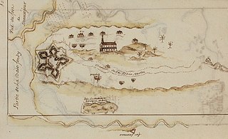
Fort Beauséjour, renamed Fort Cumberland in 1755, is a large, five-bastioned fort on the Isthmus of Chignecto in eastern Canada, a neck of land connecting the present-day province of New Brunswick with that of Nova Scotia. The site was strategically important in Acadia, a French colony that included primarily the Maritimes, the eastern part of Quebec, and northern Maine of the later United States. The fort was built by the French from 1751 to 1752. They surrendered it to the British in 1755 after their defeat in the Battle of Fort Beauséjour, during the Seven Years' War. The British renamed the structure as Fort Cumberland. The fort was strategically important throughout the Anglo-French rivalry of 1749–63, known as the French and Indian Wars by British colonists. Less than a generation later, it was the site of the 1776 Battle of Fort Cumberland, when the British forces repulsed sympathisers of the American Revolution.
Port Elgin is a former Canadian village in Westmorland County, New Brunswick. It is located near the Nova Scotia border at the mouth of the Gaspereaux River where it empties into the Northumberland Strait's Baie Verte and is now part of the rural community of Strait Shores.
The Acadians are the descendants of 17th and 18th century French settlers in parts of Acadia in the northeastern region of North America comprising what is now the Canadian Maritime Provinces of New Brunswick, Nova Scotia and Prince Edward Island, the Gaspé peninsula in eastern Québec, and the Kennebec River in southern Maine.
Aulac is a Canadian community in Westmorland County, New Brunswick. As of January 1, 2023 it is part of the Municipality of Tantramar which consists of the former town of Sackville, Village of Dorchester, Pointe de Bute and other rural communities. It is located between the former college town of Sackville and the provincial border with Nova Scotia.
The history of New Brunswick covers the period from the arrival of the Paleo-Indians thousands of years ago to the present day. Prior to European colonization, the lands encompassing present-day New Brunswick were inhabited for millennia by the several First Nations groups, most notably the Maliseet, Mi'kmaq, and the Passamaquoddy.
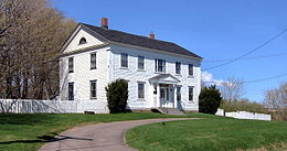
Fort Lawrence is a Canadian rural community located on the Isthmus of Chignecto in Cumberland County, Nova Scotia, which is named after Fort Lawrence.
The history of Moncton extends back thousands of years, with its first inhabitants being the First Nations of the region, such as the Mi'kmaq. Located in New Brunswick, Moncton's motto is Resurgo, which is Latin for I rise again. This motto was originally chosen in celebration of the city's rebirth in 1875 after the recovery of the economy from the collapse of the shipbuilding industry. The city again lived up to its motto in more recent times, when the economy of the city was devastated once more during the 1980s as a result of the city's largest employers all departing the city in short order. The city has since rebounded due to growth in the light manufacturing, technology, distribution, tourism, and retail sectors of the economy and is now the fastest growing city in Canada east of Toronto.
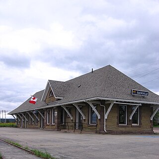
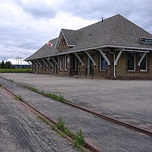
The Sackville station is an inter-city railway station in Sackville, New Brunswick. It is operated by Via Rail. The station was staffed until October 2012. The building is now closed, though Via Rail passenger trains continue to stop at the station. Checked baggage service is now handled by on-train crew members.
LaPlanche Street is the historic connector between Nova Scotia and New Brunswick, Canada. Located on the Isthmus of Chignecto, LaPlanche crosses the Tantramar Marshes between Amherst, NS and Sackville, NB. Historically, it hosted the key forts of peninsular Nova Scotia and continental Acadia and witnessed the Battle of Fort Beauséjour, the key battle between the two colonies during the Seven Years' War, and the Battle of Fort Cumberland of the American Revolutionary War.
The Acadian Exodus happened during Father Le Loutre's War (1749–1755) and involved almost half of the total Acadian population of Nova Scotia deciding to relocate to French controlled territories. The three primary destinations were: the west side of the Mesagoueche River in the Chignecto region, Isle Saint-Jean and Île-Royale. The leader of the Exodus was Father Jean-Louis Le Loutre, whom the British gave the code name "Moses". Le Loutre acted in conjunction with Governor of New France, Roland-Michel Barrin de La Galissonière, who encouraged the Acadian migration. A prominent Acadian who transported Acadians to Ile St. Jean and Ile Royal was Joseph-Nicolas Gautier. The overall upheaval of the early 1750s in Nova Scotia was unprecedented. Present-day Atlantic Canada witnessed more population movements, more fortification construction, and more troop allocations than ever before in the region. The greatest immigration of the Acadians between 1749 and 1755 took place in 1750. Primarily due to natural disasters and British raids, the Exodus proved to be unsustainable when Acadians tried to develop communities in the French territories.
This is a bibliography of notable works on New Brunswick, Canada.
Tantramar is a town in the Canadian province of New Brunswick. It was formed through the 2023 New Brunswick local governance reforms.