Related Research Articles
Zeeland is the westernmost and least populous province of the Netherlands. The province, located in the southwest of the country, borders North Brabant to the east, South Holland to the north, as well as the country of Belgium to the south and west. It consists of a number of islands and peninsulas and a strip bordering the Flemish provinces of East and West Flanders. Its capital is Middelburg with a population of 48,544 as of November 2019, although the largest municipality in Zeeland is Terneuzen. Zeeland has two seaports: Vlissingen and Terneuzen. Its area is 2,934 square kilometres (1,130 sq mi), of which 1,151 square kilometres (440 sq mi) is water; it has a population of 383,689.

The Eastern Scheldt is a former estuary in the province of Zeeland, Netherlands, between Schouwen-Duiveland and Tholen on the north and Noord-Beveland and Zuid-Beveland on the south. It also features the largest national park in the Netherlands, founded in 2002.

Hulst is a municipality and city in southwestern Netherlands in the east of Zeelandic Flanders.

Schouwen-Duiveland is a municipality and an island in the southwestern Netherlands province of Zeeland. The municipality has 33,737 inhabitants and covers an area of 488.94 square kilometres.

het Bildt is a former municipality in the province of Friesland in the northern Netherlands; its capital was Sint Annaparochie. The population was data missing in 2021. On 1 January 2018 it merged with the municipalities of Franekeradeel, Menameradiel and parts of Littenseradiel to form the new municipality Waadhoeke.

Schoonhoven is a city and former municipality in the western Netherlands, in the province of South Holland. Since 2015 it has been a part of the municipality of Krimpenerwaard, before it had been an independent municipality.

The Western Scheldt in the province of Zeeland in the southwestern Netherlands, is the estuary of the Scheldt river. This river once had several estuaries, but the others are now disconnected from the Scheldt, leaving the Westerschelde as its only direct route to the sea. The Western Scheldt is an important shipping route to the Port of Antwerp, Belgium. Unlike the Eastern Scheldt estuary, it could not be closed off from the sea by a dam as part of the Delta Works. Instead, the dykes around it have been heightened and reinforced.

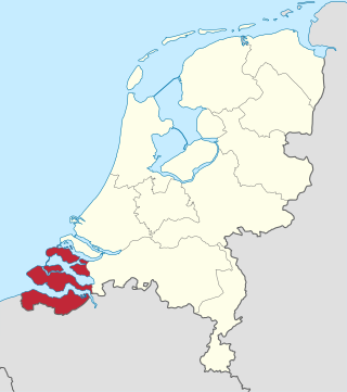
Zeelandic Flanders is the southernmost region of the province of Zeeland in the south-western Netherlands. It lies south of the Western Scheldt that separates the region from the remainder of Zeeland and the Netherlands to the north. Zeelandic Flanders is bordered to the south and to the east by Belgium.

Zuid-Beveland is part of the province of Zeeland in the Netherlands north of the Western Scheldt and south of the Eastern Scheldt.
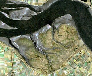
Saeftinghe or Saaftinge was a town in the southwest Netherlands, located in eastern Zeelandic Flanders, near Nieuw-Namen. It existed until 1584. It is now a swamp known as the Drowned Land of Saeftinghe and an official nature reserve area. The land is a crosspoint where the river Scheldt meets the salty waters of the North Sea in the estuary Western Scheldt. It is a treacherous place where the tides easily consume large stretches of land in a matter of seconds and must not be explored without an experienced guide.

The Dollart or Dollard is a bay in the Wadden Sea between the northern Netherlands and Germany, on the west side of the estuary of the Ems river. Most of it dries at low tide. Many water birds feed there.

Yerseke is a village situated on the southern shore of the Oosterschelde estuary in the Dutch province of Zeeland. A separate municipality until 1970, it today forms part of the municipality of Reimerswaal. As of 2010 Yerseke had a recorded population of 6,695 inhabitants, living in 2,680 households.

Het Verdronken Land van Reimerswaal is an area of flood-covered land in Zeeland in the Netherlands between Noord Beveland and Bergen op Zoom. Some of it was lost in the St. Felix's Flood in 1530, and some of it in 1532. The Oosterschelde formerly flowed along its east and north edges. It is sometimes divided into the "Verdronken Land van Zuid-Beveland" and the "Verdronken Land van de Markiezaat van Bergen op Zoom". Verdronken is Dutch for "drowned", and Markizaat van Bergen op Zoom is the marquisate of Bergen op Zoom).
Drowned lands is a name sometimes given to seasonally flooded areas, or to areas flooded by reservoirs. Sometimes it is poetically applied to lands said to have been lost to the sea, such as Lyonesse.

Doel is a subdivision of the municipality of Beveren in the Flemish province of East Flanders in Belgium. It is located near the river the Scheldt, in a polder of the Waasland. Since 1965, there have been plans to extend the Port of Antwerp into Doel and demolish the village. However, protests have caused a stalemate. On 30 March 2022, a deal was reached and the village is allowed to exist.

Flood control is an important issue for the Netherlands, as due to its low elevation, approximately two thirds of its area is vulnerable to flooding, while the country is densely populated. Natural sand dunes and constructed dikes, dams, and floodgates provide defense against storm surges from the sea. River dikes prevent flooding from water flowing into the country by the major rivers Rhine and Meuse, while a complicated system of drainage ditches, canals, and pumping stations keep the low-lying parts dry for habitation and agriculture. Water control boards are the independent local government bodies responsible for maintaining this system.

Folklore of the Low Countries, often just referred to as Dutch folklore, includes the epics, legends, fairy tales and oral traditions of the people of Belgium, Netherlands and Luxembourg. Traditionally this folklore is written or spoken in Dutch or in one of the regional languages of these countries.

The Rhine–Meuse–Scheldt delta is a river delta in the Netherlands formed by the confluence of the Rhine, the Meuse and the Scheldt rivers. In some cases, the Scheldt delta is considered a separate delta to the Rhine–Meuse delta. The result is a multitude of islands, branches and branch names that may at first sight look bewildering, especially as a waterway that appears to be one continuous stream may change names as many as seven times, e.g. Rhine → Bijlands Kanaal → Pannerdens Kanaal → Nederrijn → Lek → Nieuwe Maas → Het Scheur → Nieuwe Waterweg. Since the Rhine contributes most of the water, the shorter term Rhine Delta is commonly used. However, this name is also used for the delta where the Alpine Rhine flows into Lake Constance, so it is clearer to call the larger one Rhine–Meuse delta, or even Rhine–Meuse–Scheldt delta, as the Scheldt ends in the same delta. By some calculations, the delta covers 25,347 km2 (9,787 sq mi), making it the largest in Europe.

Saeftinghe Castle was a castle on the northeast tip of the drowned land of Saeftinghe. It was destroyed by flooding in the 16th century, and now its exact location is unknown.

Zaamslag Castle was a Motte-and-bailey castle in Zeelandic Flanders, the motte remains. It is called Torenberg.
References
- ↑ Vossen, Nick (2022-02-06). "Lokaal Spookverhaal: Het Verdronken Land van Saeftinghe • Kort Verhaal". De Nachtvlinders (in Dutch). Retrieved 2022-09-23.
- ↑ "De legende van Het Verdronken Land van Saeftinghe". Cafe Het Verdronken Land (in Dutch). Retrieved 2022-09-23.