Saegertown, Pennsylvania

Last updated
Saegertown, Pennsylvania
Saegertown, Pennsylvania.jpg
A street in Saegertown
Flag of Saegertown, Pennsylvania.png
Logo of Saegertown, Pennsylvania.png
Crawford County Pennsylvania Incorporated and Unincorporated areas Saegertown Highlighted.svg
Location of Saegertown in Crawford County, Pennsylvania (left) and of Crawford County in Pennsylvania
USA Pennsylvania location map.svg
Red pog.svg
Saegertown
Location of Saegertown in Pennsylvania
Coordinates: 41°43′10″N80°8′44″W / 41.71944°N 80.14556°W / 41.71944; -80.14556
CountryUnited States
State Pennsylvania
County Crawford
Founded1824
Government
  MayorDave Myers [1]
Area
[2]
  Total1.45 sq mi (3.74 km2)
  Land1.45 sq mi (3.74 km2)
  Water0.00 sq mi (0.00 km2)
Elevation
[3] (middle of borough)
1,115 ft (340 m)
Highest elevation
[3] (east side of borough)
1,330 ft (410 m)
Lowest elevation1,100 ft (300 m)
Population
 (2020) [4]
  Total869
  Density602.77/sq mi (232.73/km2)
Time zone UTC-4 (EST)
  Summer (DST) UTC-5 (EDT)
ZIP code
16433 [5]
Area code 814
Website www.saegertownpa.com

Saegertown is a borough in Crawford County, Pennsylvania. The population was 869 at the time of the 2020 census, [6] down from 997 at the 2010 census. [7] It was established in 1824.

Contents

History

"The settlement began at was is now known as Saegertown ca. 1795, when the brothers, Arthur and Patrick McGill, came to Woodcock Township. After Major Roger Alden built a sawmill in Saegertown, approximately 1800, the settlement was known for several years as Aldens Mill. In 1824, Daniel Saeger bought Alden's mill and adjacent lands and at the age of 44, he laid out the town under its present name. Saeger, a native of Pennsylvania of German descent, left Egypt, Pa. in 1823 to find a suitable place to settle. After he arrived in Saegertown, he attracted to the area a large number of German Yeomanry from Lehigh and other eastern Pa. counties. Being active in the community, Saeger was an early member of the Lutheran Church, the owner of a sawmill and general store, and a justice of the peace. He was a member of the Pa. State Legislature." [8]

The Edward Saeger House was added to the National Register of Historic Places in 1980. [9]

Geography

Saegertown is located north of the center of Crawford County at 41°43′10″N80°8′44″W / 41.71944°N 80.14556°W / 41.71944; -80.14556 (41.719482, -80.145660). [10] It is bordered to the north, east, and south by Woodcock Township and to the west, across French Creek, by Hayfield Township.

U.S. routes 19 and 6 pass together through the center of town, leading northeast 8 miles (13 km) to Cambridge Springs and south 6 miles (10 km) to Meadville, the Crawford County seat. Pennsylvania Route 198 leads southeast 6 miles (10 km) to Blooming Valley and west 3 miles (5 km) to Exit 154 on Interstate 79. Via I-79, it is 32 miles (51 km) north to Erie and 95 miles (153 km) south to Pittsburgh.

According to the United States Census Bureau, the borough has a total area of 1.5 square miles (4.0 km2), all land. [7]

Demographics

Historical population
CensusPop.Note
1860 352
1870 44125.3%
1880 67853.7%
1890 7459.9%
1900 607−18.5%
1910 71217.3%
1920 659−7.4%
1930 645−2.1%
1940 75316.7%
1950 83611.0%
1960 1,13135.3%
1970 1,34819.2%
1980 942−30.1%
1990 1,06613.2%
2000 1,0710.5%
2010 997−6.9%
2020 869−12.8%
2022 (est.)859 [6] −1.2%
U.S. Decennial Census [11]

As of the census [12] of 2000, there were 1,071 people, 361 households, and 251 families residing in the borough. The population density was 743.5 inhabitants per square mile (287.1/km2). There were 378 housing units at an average density of 262.4 per square mile (101.3/km2). The racial makeup of the borough was 95.05% White, 2.52% African American, 0.37% Native American, 0.19% Asian, 0.65% from other races, and 1.21% from two or more races. Hispanic or Latino of any race were 0.65% of the population.

There were 361 households, out of which 32.7% had children under the age of 18 living with them, 56.0% were married couples living together, 10.5% had a female householder with no husband present, and 30.2% were non-families. 25.5% of all households were made up of individuals, and 13.0% had someone living alone who was 65 years of age or older. The average household size was 2.45 and the average family size was 2.94.

In the borough the population was spread out, with 20.5% under the age of 18, 11.3% from 18 to 24, 33.3% from 25 to 44, 20.7% from 45 to 64, and 14.1% who were 65 years of age or older. The median age was 36 years. For every 100 females there were 122.7 males. For every 100 females age 18 and over, there were 125.1 males.

The median income for a household in the borough was $32,500, and the median income for a family was $39,688. Males had a median income of $28,281 versus $22,500 for females. The per capita income for the borough was $16,163. About 4.0% of families and 5.7% of the population were below the poverty line, including 6.4% of those under age 18 and none of those age 65 or over.

Notable people

Related Research Articles

<span class="mw-page-title-main">Crawford County, Pennsylvania</span> County in Pennsylvania, United States

Crawford County is a county in the Commonwealth of Pennsylvania. As of the 2020 census, the population was 83,938. Its county seat is Meadville. The county was created on March 12, 1800, from part of Allegheny County and named for Colonel William Crawford.

<span class="mw-page-title-main">Blooming Valley, Pennsylvania</span> Borough in Pennsylvania, United States

Blooming Valley is a borough in Crawford County, Pennsylvania, United States. The population was 342 at the 2020 census, up from 337 at the 2010 census.

<span class="mw-page-title-main">Cambridge Springs, Pennsylvania</span> Home rule municipality in Pennsylvania, United States

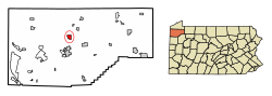
Cambridge Springs is a borough with home rule status in Crawford County, Pennsylvania, United States. The population was 2,583 at the 2020 census, down from 2,595 at the 2010 census.

<span class="mw-page-title-main">Cochranton, Pennsylvania</span> Borough in Pennsylvania, United States

Cochranton is a borough in Crawford County, Pennsylvania, United States. The population was 1,124 at the 2020 census, down from 1,136 as of the 2010 census.

<span class="mw-page-title-main">Conneaut Lake, Pennsylvania</span> Borough in Pennsylvania, United States

Conneaut Lake is a borough in Crawford County, Pennsylvania, located at the southern end of the lake of the same name. The population was 625 at the 2020 census, down from 653 at the 2010 census.

<span class="mw-page-title-main">Conneaut Lakeshore, Pennsylvania</span> Census-designated place in Pennsylvania, United States

Conneaut Lakeshore is a census-designated place (CDP) in Crawford County, Pennsylvania, United States. The population was 2,395 at the 2010 census.

<span class="mw-page-title-main">Conneautville, Pennsylvania</span> Borough in Pennsylvania, United States

Conneautville is a borough in Crawford County, Pennsylvania, United States, situated along Conneaut Creek. The population was 736 at the 2020 census, down from 774 at the 2010 census.

<span class="mw-page-title-main">Greenwood Township, Crawford County, Pennsylvania</span> Township in Pennsylvania, United States

Greenwood Township is a township in Crawford County, Pennsylvania, United States. The population was 1,424 at the 2020 census, down from 1,454 at the 2010 census.

<span class="mw-page-title-main">Hayfield Township, Crawford County, Pennsylvania</span> Township in Pennsylvania, United States

Hayfield Township is a township in Crawford County, Pennsylvania, United States. The population was 2,776 at the 2020 census, down from 2,940 at the 2010 census.

<span class="mw-page-title-main">Meadville, Pennsylvania</span> City in Pennsylvania, United States

Meadville is a city in and the county seat of Crawford County, Pennsylvania, United States. The population was 13,050 at the 2020 census. The first permanent settlement in Northwestern Pennsylvania, Meadville is within 40 miles (64 km) of Erie and within 90 miles (140 km) of Pittsburgh. It is the principal city of the Meadville micropolitan area, as well as part of the larger Erie–Meadville combined statistical area.

<span class="mw-page-title-main">Springboro, Pennsylvania</span> Borough in Pennsylvania, United States

Springboro is a borough in Crawford County, Pennsylvania, United States, located 35 miles southwest of Erie. The population was 376 at the 2020 census, down from 477 at the 2010 census.

<span class="mw-page-title-main">Townville, Pennsylvania</span> Borough in Pennsylvania, United States

Townville is a borough in Crawford County, Pennsylvania, United States. The population was 326 at the 2020 census, up from 323 at the 2010 census.

<span class="mw-page-title-main">Union Township, Crawford County, Pennsylvania</span> Township in Pennsylvania, United States

Union Township is a township in Crawford County, Pennsylvania, United States. The population was 857 at the 2020 census, down from 1,010 at the 2010 census.

<span class="mw-page-title-main">Venango, Pennsylvania</span> Borough in Pennsylvania, United States

Venango is a borough in Crawford County, Pennsylvania, United States. The population was 210 at the 2020 census, down from 239 at the 2010 census, down from 288 in 2000.

<span class="mw-page-title-main">Vernon Township, Pennsylvania</span> Township in Pennsylvania, United States

Vernon Township is a township in Crawford County, Pennsylvania, United States. The population was 5,310 at the 2020 census, down from 5,630 at the 2010 census.

<span class="mw-page-title-main">West Mead Township, Pennsylvania</span> Township in Pennsylvania, United States

West Mead Township is a township in Crawford County, Pennsylvania, United States. The population was 5,040 at the 2020 census, down from 5,249 at the 2010 census.

<span class="mw-page-title-main">Woodcock, Pennsylvania</span> Borough in Pennsylvania, United States

Woodcock is a borough in Crawford County, Pennsylvania, United States. The population was 140 at the 2020 census, down from 157 at the 2010 census.

<span class="mw-page-title-main">Woodcock Township, Pennsylvania</span> Township in Pennsylvania, United States

Woodcock Township is a township in Crawford County, Pennsylvania, United States. The population was 2,756 at the 2020 census, down from 2,856 at the 2010 census.

<span class="mw-page-title-main">Cranesville, Pennsylvania</span> Borough in Pennsylvania, United States

Cranesville is a borough in Erie County, Pennsylvania, United States. The population was 572 at the 2020 census. It is part of the Erie Metropolitan Statistical Area.

<span class="mw-page-title-main">McKean, Pennsylvania</span> Borough in Pennsylvania, United States

McKean is a borough in Erie County, Pennsylvania. The population was 475 at the time of the 2020 census. It is part of the Erie–Meadville combined statistical area. McKean was known as "Middleboro" until it officially changed its name in 1970.

References

  1. "Administration & Personnel – Saegertown Borough".
  2. "ArcGIS REST Services Directory". United States Census Bureau. Retrieved October 16, 2022.
  3. 1 2 3 "Saegertown Topo Map, Crawford County PA (Meadville Area)". TopoZone. Locality, LLC. Retrieved 2 September 2019.
  4. "Census Population API". United States Census Bureau. Retrieved Oct 12, 2022.
  5. "Saegertown PA ZIP Code". zipdatamaps.com. 2023. Retrieved June 27, 2023.
  6. 1 2
  7. 1 2 "Geographic Identifiers: 2010 Census Summary File 1 (G001): Saegertown borough, Pennsylvania". U.S. Census Bureau, American Factfinder. Archived from the original on February 13, 2020. Retrieved June 4, 2015.
  8. "National Register of Historic Places Inventory Nomination Form: Edward Saeger House" (PDF).
  9. "National Register Information System". National Register of Historic Places . National Park Service. July 9, 2010.
  10. "US Gazetteer files: 2010, 2000, and 1990". United States Census Bureau. 2011-02-12. Retrieved 2011-04-23.
  11. "Census of Population and Housing". Census.gov. Retrieved June 4, 2016.
  12. "U.S. Census website". United States Census Bureau . Retrieved 2008-01-31.