Saint-Jude, Quebec

Last updated
Saint-Jude
Saint-Jude.jpg
Saint-Jude Quebec location diagram.PNG
Location within Les Maskoutains RCM
Canada Southern Quebec location map.png
Red pog.svg
Saint-Jude
Location in southern Quebec
Coordinates: 45°46′N72°59′W / 45.767°N 72.983°W / 45.767; -72.983 Coordinates: 45°46′N72°59′W / 45.767°N 72.983°W / 45.767; -72.983 [1]
Country Canada
Province Quebec
Region Montérégie
RCM Les Maskoutains
ConstitutedJuly 1, 1855
Government
  MayorYves de Bellefeuille
   Federal riding Saint-Hyacinthe—Bagot
   Prov. riding Richelieu
Area
  Total77.90 km2 (30.08 sq mi)
  Land77.32 km2 (29.85 sq mi)
Population
 (2011) [4]
  Total1,235
  Density16.0/km2 (41/sq mi)
  Pop 2006-2011
Increase2.svg 9.3%
  Dwellings
495
Time zone UTC−5 (EST)
  Summer (DST) UTC−4 (EDT)
Postal code(s)
Area code(s) 450 and 579
HighwaysQc235.svg Route 235
Website www.saint-jude.ca OOjs UI icon edit-ltr-progressive.svg

Saint-Jude is a municipality in southwestern Quebec, Canada in the Regional County Municipality of Les Maskoutains. The population as of the Canada 2011 Census was 1,235.

Contents

Demographics

Population

Canada census – Saint-Jude community profile
2021 2011
Population1,326 (+9.2% from 2016)1,235 (+9.3% from 2006)
Land area77.33 km2 (29.86 sq mi)77.32 km2 (29.85 sq mi)
Population density17.1/km2 (44/sq mi)16.0/km2 (41/sq mi)
Median age40 (M: 39.6, F: 40.4)36.9 (M: 37.8, F: 36.4)
Total private dwellings525495
Median household income$47,068
References: 2021 [5] 2011 [4] earlier [6] [7]
Historical Census Data - Saint-Jude, Quebec [8]
YearPop.±%
1991 1,133    
1996 1,143+0.9%
2001 1,126−1.5%
2006 1,130+0.4%
2011 1,235+9.3%

Language

Canada Census Mother Tongue - Saint-Jude, Quebec [8]
CensusTotal
French
English
French & English
Other
YearResponsesCountTrendPop %CountTrendPop %CountTrendPop %CountTrendPop %
2011
1,230
1,205Increase2.svg 10.0%97.97%10Increase2.svg n/a%0.81%5Decrease2.svg 50.0%0.41%10Decrease2.svg 50.0%0.81%
2006
1,125
1,095Decrease2.svg 0.9%97.33%0Steady2.svg 0.0%0.00%10Increase2.svg n/a%0.89%20Steady2.svg 0.0%1.78%
2001
1,125
1,105Increase2.svg 1.8%98.22%0Decrease2.svg 100.0%0.00%0Steady2.svg 0.0%0.00%20Increase2.svg 100.0%1.78%
1996
0
1,085n/a0.00%45n/a0.00%0n/a0.00%10n/a0.00%

Communities

See also

Related Research Articles

Beauharnois-Salaberry Regional County Municipality Regional county municipality in Quebec, Canada

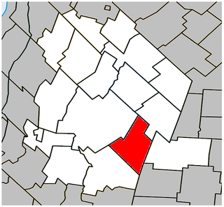
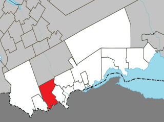
Beauharnois-Salaberry is a regional county municipality in the Montérégie region of Quebec, Canada. Its seat is Beauharnois.

Lac-Saint-Jean-Est Regional County Municipality Regional county municipality in Quebec, Canada

Lac-Saint-Jean-Est is a regional county municipality in the Saguenay–Lac-Saint-Jean region of Quebec, Canada. The seat is Alma. In 2016, 99.3% reported that they spoke French most often at home, according to the census.

Le Domaine-du-Roy Regional County Municipality Regional county municipality in Quebec, Canada

Le Domaine-du-Roy(The King's Domain) is a regional county municipality in the Saguenay-Lac-Saint-Jean region of Quebec, Canada. Its seat is in Roberval, and it is named for the King of France, who owned the land at the time of the colonization of Quebec.

Le Val-Saint-François Regional County Municipality Regional county municipality in Quebec, Canada

Le Val-Saint-François is a regional county municipality in the Estrie region of Quebec, Canada. The seat is Richmond.

Saint-Michel, Quebec Municipality in Quebec, Canada

Saint-Michel is a municipality in the Jardins de Napierville Regional County Municipality in Quebec, Canada, situated in the Montérégie administrative region. The population as of the Canada 2021 Census was 3,521.

Saint-Alexandre, Quebec Municipality in Quebec, Canada

Saint-Alexandre is a municipality in the province of Quebec, Canada, located in the Regional County Municipality of Le Haut-Richelieu. The population as of the Canada 2011 Census was 2,495. Residents of Saint-Alexandre are called Alexandrins.

Saint-Alexis-de-Matapédia, Quebec Municipality in Quebec, Canada

Saint-Alexis-de-Matapédia is a village and municipality in the Gaspésie–Îles-de-la-Madeleine region of eastern Quebec, Canada.

Saint-Cyprien-de-Napierville Municipality in Quebec, Canada

Saint-Cyprien-de-Napierville is a municipality in Les Jardins-de-Napierville Regional County Municipality in Quebec, Canada, situated in the Montérégie administrative region. The population as of the Canada 2021 Census was 1,735. It completely encircles the village of Napierville.

Saint-Mathieu, Quebec Municipality in Quebec, Canada

Saint-Mathieu is a municipality situated in the Montérégie administrative region in Quebec, Canada. The population as of the Canada 2016 Census was 2,156. It is part of the Roussillon Regional County Municipality.

Saint-Louis-de-Gonzague, Montérégie, Quebec Parish municipality in Quebec, Canada

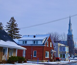
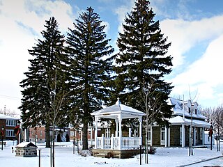
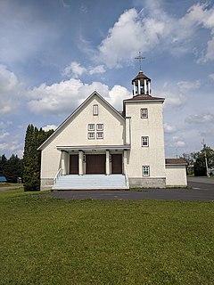
Saint-Louis-de-Gonzague is a parish municipality in the Beauharnois-Salaberry Regional County Municipality in the Montérégie region of Quebec, Canada. The population as of the Canada 2021 Census was 1,950.

Saint-Isidore, Montérégie, Quebec Parish municipality in Quebec, Canada

Saint-Isidore is a parish municipality in Roussillon Regional County Municipality in the Montérégie administrative region of Quebec, Canada. The population as of the Canada 2011 Census was 2,581. It is the hometown of mixed martial arts champion Georges St-Pierre.

Saint-Dominique, Quebec Municipality in Quebec, Canada

Saint-Dominique is a municipality in the Montérégie region of southwestern Quebec. The population as of the Canada 2011 Census was 2,327.

Saint-Damase, Montérégie, Quebec Municipality in Quebec, Canada

Saint-Damase is a municipality located in Les Maskoutains Regional County Municipality in the Montérégie region of Quebec. The population as of the Canada 2011 Census was 2,506. The municipality was created on October 5, 2001, by the merger of the Parish and the Village of Saint-Damase.

Saint-Bernard-de-Michaudville Municipality in Quebec, Canada

Saint-Bernard-de-Michaudville is a municipality in southwestern Quebec, Canada in the Regional County Municipality of Les Maskoutains. The population as of the Canada 2021 Census was 616. The community was officially renamed from the Parish of Saint-Bernard-Partie-Sud to the Municipality of Saint-Bernard-de-Michaudville on July 19, 1997.

Rivière-Saint-Jean is a municipality and village in the Côte-Nord region of the province of Quebec in Canada.

Saint-Elzéar, Gaspésie–Îles-de-la-Madeleine, Quebec Municipality in Quebec, Canada

Saint-Elzéar is a municipality in Quebec, Canada.

Saint-Alphonse, Gaspésie–Îles-de-la-Madeleine, Quebec Municipality in Quebec, Canada

Saint-Alphonse is a municipality in Quebec, Canada.

Saint-François-dAssise, Quebec Municipality in Quebec, Canada

Saint-François-d'Assise is a municipality in Quebec, Canada.

Saint-Alexandre-des-Lacs Parish municipality in Quebec, Canada

Saint-Alexandre-des-Lacs is a parish municipality in Quebec, Canada.

Saint-Damase, Bas-Saint-Laurent, Quebec Parish municipality in Quebec, Canada

Saint-Damase is a parish municipality in Quebec, Canada.

References

  1. Reference number 313212 of the Commission de toponymie du Québec (in French)
  2. 1 2 Ministère des Affaires municipales, des Régions et de l'Occupation du territoire: Saint-Jude
  3. Parliament of Canada Federal Riding History: SAINT-HYACINTHE--BAGOT (Quebec)
  4. 1 2 3 "2011 Community Profiles". 2011 Canadian Census . Statistics Canada. March 21, 2019. Retrieved 2014-03-19.
  5. "2021 Community Profiles". 2021 Canadian Census . Statistics Canada. February 4, 2022. Retrieved 2022-04-27.
  6. "2006 Community Profiles". 2006 Canadian Census . Statistics Canada. August 20, 2019.
  7. "2001 Community Profiles". 2001 Canadian Census . Statistics Canada. July 18, 2021.
  8. 1 2 Statistics Canada: 1996, 2001, 2006, 2011 census

Commons-logo.svg Media related to Saint-Jude, Quebec at Wikimedia Commons