
Sault Ste. Marie is a city in the Upper Peninsula of the U.S. state of Michigan. It is the county seat of Chippewa County and is the only city within the county. With a population of 13,337 at the 2020 census, it is the second-most populated city in the Upper Peninsula, behind Marquette. It is the primary city of the Sault Ste. Marie, MI Micropolitan Statistical Area, which encompasses all of Chippewa County and had a population of 36,785 at the 2020 census. Sault Ste. Marie was settled by mostly French colonists in 1668, making it the oldest city in Michigan.

Small hydro is the development of hydroelectric power on a scale suitable for local community and industry, or to contribute to distributed generation in a regional electricity grid. Exact definitions vary, but a "small hydro" project is less than 50 megawatts (MW), and can be further subdivide by scale into "mini" (<1MW), "micro" (<100 kW), "pico" (<10 kW). In contrast many hydroelectric projects are of enormous size, such as the generating plant at the Three Gorges Dam at 22,500 megawatts or the vast multiple projects of the Tennessee Valley Authority.

The St. Marys River, sometimes written St. Mary's River, drains Lake Superior, starting at the end of Whitefish Bay and flowing 74.5 miles (119.9 km) southeast into Lake Huron, with a fall of 23 feet (7.0 m). For its entire length it is an international border, separating Michigan in the United States from Ontario, Canada.
The Soo Locks are a set of parallel locks, operated and maintained by the United States Army Corps of Engineers, Detroit District, that enable ships to travel between Lake Superior and the lower Great Lakes. They are located on the St. Marys River between Lake Superior and Lake Huron, between the Upper Peninsula of the U.S. state of Michigan and the Canadian province of Ontario. They bypass the rapids of the river, where the water falls 21 ft (6.4 m). The locks pass an average of 10,000 ships per year, despite being closed during the winter from January through March, when ice shuts down shipping on the Great Lakes. The winter closure period is used to inspect and maintain the locks.

An underground power station is a type of hydroelectric power station constructed by excavating the major components from rock, rather than the more common surface-based construction methods.
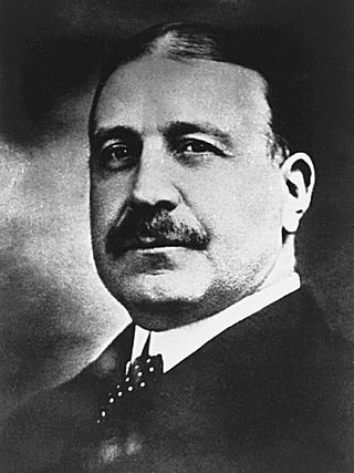
Francis Hector Clergue was an American businessman who became the leading industrialist of Sault Ste. Marie, Ontario, Canada, at the turn of the 20th century.
The Bay D'Espoir Hydroelectric Development, built by the Newfoundland and Labrador Power Commission is located on the south coast of Newfoundland near the rural community of Bay d'Espoir. It was the second major hydroelectric project undertaken on Newfoundland.
Edison Sault Electric Company was a public utility that provided electricity to the eastern portion of Michigan's Upper Peninsula. Its service area covered four counties.

Folsom Powerhouse State Historic Park is a historical site preserving an 1895 alternating current (AC) hydroelectric power station—one of the first in the United States.

WEC Energy Group is an American company based in Milwaukee, Wisconsin that provides electricity and natural gas to 4.4 million customers across four states.

The Robert Moses Niagara Hydroelectric Power Station is a hydroelectric power station in Lewiston, New York, near Niagara Falls. Owned and operated by the New York Power Authority (NYPA), the plant diverts water from the Niagara River above Niagara Falls and returns the water into the lower portion of the river near Lake Ontario. It uses 13 generators at an installed capacity of 2,525 MW (3,386,000 hp).

Croton Dam is an earth-filled embankment dam and powerplant complex on the Muskegon River in Croton Township, Newaygo County, Michigan. It was built in 1907 under the direction of William D. Fargo by the Grand Rapids - Muskegon Power Company, a predecessor of Consumers Energy. The 40-foot-high (12 m) dam impounds 7.2 billion U.S. gallons (6 billion imp. gal/27 billion L) of water in its 1,209-acre (489 ha) reservoir and is capable of producing 8,850 kilowatts at peak outflow. It was listed on the National Register of Historic Places in 1979.

The Edison Sault Power Canal supplies the Saint Marys Falls Hydropower Plant, a Cloverland Electric Cooperative hydroelectric plant, in Sault Ste. Marie, Michigan. Excavation of the power canal began in September 1898 and was completed in June 1902. The canal and hydroelectric complex were named a Historic Civil Engineering Landmark in 1983.
Hydroelectricity is, as of 2019, the second-largest renewable source of energy in both generation and nominal capacity in the United States. In 2021, hydroelectric power produced 31.5% of the total renewable electricity, and 6.3% of the total U.S. electricity.

Sault Ste. Marie Bridge Company is a subsidiary of the Wisconsin Central Ltd. It operates a railroad bridge over the St. Marys River between Sault Ste. Marie, Michigan and Sault Ste. Marie, Ontario.
Ohio Falls Station is a hydroelectric power station owned by Louisville Gas & Electric (LG&E) and Kentucky Utilities (KU) which is located three miles west of Downtown Louisville, Kentucky. The generating station is located on Shippingport Island at the site of the McAlpine Dam and locks along the Ohio River in Kentucky. The plant was built in 1923 by Byllesby Engineering and Management Corporation and the U.S. Army Corps of Engineers. The plant featured eight 10.4 MW units operating at roughly 13,500 hp per unit. Each unit was composed of Allis-Chalmers turbines and General Electric generators. The plant is located inside the Ohio Natural Wildlife Conservation Area and is considered a large impoundment hydro power plant. The station was built after a canal and dam within the Ohio river in an attempt to allow boats to navigate the 8 ft vertical drop among the falls that spanned 2 miles wide. Production of the canal and dam began in 1825. It was not until a repair on the dam was needed that Louisville engineers had the idea of building a hydroelectric station to harvest the power of the falls.

Sault Ste. Marie is a city in Ontario, Canada. The third-largest city in Northern Ontario after Sudbury and Thunder Bay, it is located on the St. Mary's River on the Canada–US border. To the southwest, across the river, is the United States and the Michigan city of the same name. The two cities are joined by the Sault Ste. Marie International Bridge, which connects Interstate 75 on the Michigan side and Huron Street on the Ontario side. Shipping traffic in the Great Lakes system bypasses the Saint Mary's Rapids via the American Soo Locks, the world's busiest canal in terms of tonnage that passes through it, while smaller recreational and tour boats use the Canadian Sault Ste. Marie Canal.
Cloverland Electric Cooperative is an electric cooperative in Michigan, United States. It serves five counties on the eastern end of Michigan's Upper Peninsula, as well as the cities of Sault Ste. Marie, Michigan and St. Ignace. Cloverland Electric Cooperative is based in Dafter, just south of Sault Ste, Marie.

The Snoqualmie Falls Hydroelectric Plant is located just north of Snoqualmie in King County, Washington state, US. It is situated about 22 mi (35 km) east of Seattle. Located just below the Snoqualmie Falls, the power plant consists of two power houses, Plant 1 and Plant 2. Plant 1 was completed in 1899 and is located underground. It is the first completely underground hydroelectric power plant ever built in the world. Plant 2 was built in 1910 and is located along the right bank of the Snoqualmie River. Both plants receive water from a small reservoir created by a weir atop the falls. Plant 1 has an installed capacity of 13.7 MW and Plant 2 a capacity of 40.2 MW for a total installed capacity of 53.9 MW, enough to power 40,000 homes.
The Sault Ste. Marie Soos were a minor league baseball team based in Sault Ste. Marie, Michigan. In 1905, Sault Ste. Marie played as members of the Copper Country Soo League, hosting minor league home games at Brady Park. The 1905 minor league Soos team was preceded by an integrated 1904 independent team.

