Saint Thomas, Barbados

Last updated
Saint Thomas
Saint Thomas in Barbados.svg
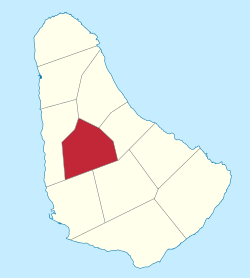
Map of Barbados showing the Saint Thomas parish
Coordinates: 13°11′N59°35′W / 13.183°N 59.583°W / 13.183; -59.583 Coordinates: 13°11′N59°35′W / 13.183°N 59.583°W / 13.183; -59.583
Country Barbados
Largest city Welchman Hall
Government
  Type Parliamentary democracy
   Parliamentary  seats1
Area
  Total34 km2 (13 sq mi)
Population
 (2010 census)
  Total14,249
  Density420/km2 (1,100/sq mi)
ISO 3166 code BB-11 [1]

The parish of Saint Thomas ("St. Thomas") is found in the centre of Barbados. It is one of only two landlocked parishes in the island, the other being Saint George to the south.

Contents

Saint Thomas is represented in the House of Assembly of Barbados by Cynthia Forde. [2]

The area of Sturges in St. Thomas contains a number of broadcast antennas for the island. Included one which fell onto nearby properties in 2018.

Geography

Populated places

There are no cities in St. Thomas. The central village of the parish is Welchman Hall. The eponymous St. Thomas Church is located west of Rock Hall on Highway 2A. The majority of the population lives in the extreme southwest of the parish, in the catchment area of Bridgetown. The biggest places there are Welches, Redmans and Arthur's Seat. Shop Hill, White Hill and Edgehill are centrally located in the southwest. Welchman Hall is in the center, Rock Hall in the West and Clifton Hill in the east. The north is sparsely populated.

The parish contains the following major villages:

Smaller villages and hamlets are:

Parishes bordering Saint Thomas

Education

In 1997, the Government of Barbados under the Ministry of Education in an attempt to create more spaces for the increase in entrants into secondary schools, opened the St. Thomas Secondary School, the precursor of the Lester Vaughan Secondary School, named after a distinguished Barbadian who assisted in the transformation of the educational sector as well as wrote the National Pledge of Barbados. To date, the Lester Vaughan School is the youngest secondary school and one of the most technologically advanced in the island.

The Barbados Association for Children With Intellectual Challenges operates the Challenor School for both children and adults with mental retardation.

Places of interest

Related Research Articles

<span class="mw-page-title-main">Bridgetown</span> Capital of Barbados

Bridgetown is the capital and largest city of Barbados. Formerly The Town of Saint Michael, the Greater Bridgetown area is located within the parish of Saint Michael. Bridgetown is sometimes locally referred to as "The City", but the most common reference is simply "Town". As of 2014, its metropolitan population stands at roughly 110,000.

<span class="mw-page-title-main">Saint Michael, Barbados</span> Parish in Barbados

The parish of St. Michael is one of eleven parishes of Barbados. It has a land area of 39 km2 (15 sq mi) and is found at the southwest portion of the island. Saint Michael has survived by name as one of the original six parishes created in 1629 by Governor Sir William Tufton.

<span class="mw-page-title-main">Christ Church, Barbados</span> Parish in Barbados

The parish of Christ Church is one of eleven historic political divisions of Barbados. It has a land area of 57 km2 (22 sq mi) and is found at the southern end of the island. Christ Church has survived by name as one of the original six parishes created in 1629 by Governor Sir William Tufton.

<span class="mw-page-title-main">Saint Andrew, Barbados</span> Parish in Barbados

Saint Andrew is one of eleven parishes of Barbados. It is situated in the northeastern area in the country.

<span class="mw-page-title-main">Saint James, Barbados</span> Parish in Barbados

The parish of Saint James is an area located in the western central part of the country of Barbados. Increasingly St. James is becoming known as the playground of the rich and famous, and as a haven for sun-starved tourists with its up-market hotel resorts.

<span class="mw-page-title-main">Saint George, Barbados</span> Parish in Barbados

The parish of Saint George is located in the interior of Barbados. It is one of two land-locked parishes, the other being Saint Thomas to the north. A prominent landmark in the parish is Gun Hill Signal Station – one of the few remaining signal stations, dating back to 1818.

<span class="mw-page-title-main">Saint John, Barbados</span> Parish in Barbados

The parish of Saint John is a parish of Barbados on the eastern side of the island. It is home to one of its secondary schools, The Lodge School. It is home to the St. John's Parish Church, which has a scenic view of the Atlantic Ocean from its perch near Hackleton's Cliff, which overlooks the East Coast of the island. In its southeastern corner, the shoreline turns northward, forming the small Conset Bay.

<span class="mw-page-title-main">Saint Joseph, Barbados</span> Parish in Barbados

The parish of Saint Joseph is a parish of Barbados on the eastern side of the island. The parish is home to two of the more notable botanic gardens in the country - Flower Forest and Andromeda Gardens. Parts of St. Joseph are also referred to as the Scotland District, a reference to the appearance of the landscape.

<span class="mw-page-title-main">Saint Lucy, Barbados</span> Parish in Barbados

The parish of Saint Lucy is the northernmost area in the country of Barbados. Saint Lucy is the only parish of Barbados out of the eleven to be named after a female patron saint, Saint Lucy of Syracuse. Saint Lucy's shape also resembles a peninsula, surrounded on three sides by the Atlantic Ocean to the north, east and west. The Harrison Point Lighthouse is located in Harrisons, Saint Lucy between Great Head and Norse's Bay, also in Saint Lucy. To the south lies the neighbouring Parish of Saint Peter.

<span class="mw-page-title-main">Saint Peter, Barbados</span> Parish in Barbados

The Parish of Saint Peter is one of eleven parishes in the Caribbean island country of Barbados. It is named after the Christian Apostle and patron saint, Saint Peter. It is located in the north of Barbados, and is the only parish besides Saint Lucy that extends from the east coast to the west.

<span class="mw-page-title-main">Saint Philip, Barbados</span> Parish in Barbados

Saint Philip is a parish of Barbados at the easternmost end of the island. Saint Philip’s Parish Church was built as the Anglican parish church in 1640.

Clifton Hill Moravian Church is a Moravian church in central Saint Thomas parish in Barbados. It was built by the Moravians who had previously settled on the island in 1839.

<span class="mw-page-title-main">Index of Barbados-related articles</span>

The following is an alphabetical list of topics related to the nation of Barbados.

<span class="mw-page-title-main">Clifton, Bedfordshire</span> Human settlement in England

Clifton is a village and civil parish in the English county of Bedfordshire. The original hundred of Clifton is named after it.

<span class="mw-page-title-main">ABC Highway</span> Highway in Barbados

The ABC Highway is the main urban highway in Barbados. Opened in 1989, it is named after three famous Barbadian politicians: John Michael Geoffrey Manningham ("Tom") Adams, Errol Barrow, and Hugh Gordon Cummins. From the east, the highway stretches from the Grantley Adams International Airport in Christ Church, to the western end at Cave Hill Road and University Drive, Cave Hill Campus, University of the West Indies, in Saint Michael. It roughly encircles the Parish of Saint Michael and the wider metropolitan area of Bridgetown.

Piggotts, also known as St Mark's Village, is a small township in Saint George Parish on Antigua island in Antigua and Barbuda. It had a population of 1,478 in 2001.

<span class="mw-page-title-main">ZR (bus)</span>

A ZR is a type of private taxi-bus system found in Barbados.

Cynthia Yvonne Forde is a Barbados born politician, first Vice Chairman of the Barbados Labour Party, member of the Barbados Union of Teachers. She has represented Saint Thomas in the House of Assembly of Barbados since 2001.

References

  1. iso:code:3166:BB, International Organization for Standardization
  2. Hon. Miss Cynthia Y. Forde, J.P., M.P.