
Yau Tsim Mong District is one of 18 districts of Hong Kong, located on the western part of Kowloon Peninsula. It is the core urban area of Kowloon. The district has the second highest population density of all districts, at 49,115 km2 (18,963 sq mi). The 2016 By-Census recorded the total population of Yau Tsim Mong District at 342,970.
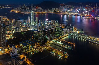
Tsim Sha Tsui, often abbreviated as TST, is an urban area in southern Kowloon, Hong Kong. The area is administratively part of the Yau Tsim Mong District. Tsim Sha Tsui East is a piece of land reclaimed from the Hung Hom Bay now east of Tsim Sha Tsui. The area is bounded north by Austin Road and in the east by Hong Chong Road and Cheong Wan Road.
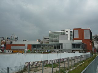
East Tsim Sha Tsui is a station of the Mass Transit Railway (MTR) system of Hong Kong. It is currently an intermediate station on the Tuen Ma line.

Nathan Road is the main thoroughfare in Kowloon, Hong Kong, aligned south–north from Tsim Sha Tsui to Sham Shui Po. It is lined with shops and restaurants and throngs with visitors, and was known in the post–World War II years as the Golden Mile, a name that is now rarely used. It starts on the southern part of Kowloon at its junction with Salisbury Road, a few metres north of Victoria Harbour, and ends at its intersection with Boundary Street in the north. Portions of the Kwun Tong and Tsuen Wan lines run underneath Nathan Road. The total length of Nathan Road is about 3.6 km (2.2 mi).
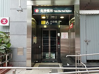
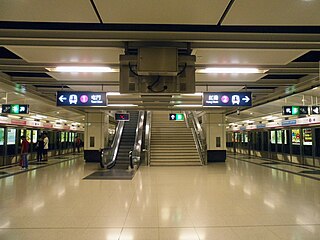
Tsim Sha Tsui is an MTR station on the Tsuen Wan line. The station, originally opened on 16 December 1979 on the Tsuen Wan line, serves the area of Tsim Sha Tsui.

Hung Hom is a passenger railway station in Hung Hom, Kowloon, Hong Kong. It is an interchange station between the East Rail line and the Tuen Ma line domestic services of the MTR network, as well as the southern terminus of cross-border through-trains to mainland China which has been suspended since 4 February 2020. The station is one of four Hong Kong ports of entry on the MTR network; the others are Lo Wu, Lok Ma Chau, and West Kowloon. This station serves the southern terminus of the East Rail Line in early morning before the first northbound train from Admiralty arrives. As the station is located next to the Cross-Harbour Tunnel's northern portal, it is also served by many cross-harbour bus routes.
The Kowloon Southern link is a section of the MTR East Rail and West Rail line linking Nam Cheong station and Hung Hom station. The rail link is fully underground, lies along the south-west coastline of Kowloon Peninsula, east of rail tracks of the Tung Chung line and Airport Express. Kowloon Southern Link has one underground intermediate station called Austin station. It is located adjacent to the Canton Road Government Offices, close to Kowloon station of Tung Chung line and Airport Express. However, the structures do not provide a direct transfer between the two stations.
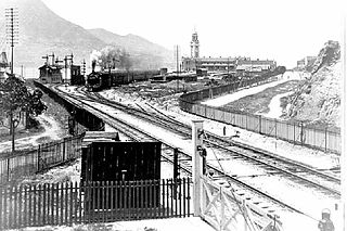
Kowloon station, colliquially Old Tsim Sha Tsui Terminal, located in Tsim Sha Tsui on the present site of the Hong Kong Cultural Centre, was the former southern terminus of the Kowloon–Canton Railway (KCR).
Austin Road is a road in-between Tsim Sha Tsui and Jordan, Kowloon, Hong Kong. It was named after John Gardiner Austin, Colonial Secretary of Hong Kong from 1868 to 1879. The northeast part of this street is noted for clubs, fields, and military buildings, while the western section is densely populated.

Middle Road is a street in the southern part of Tsim Sha Tsui, Kowloon, Hong Kong.

Mody Road is a street in Tsim Sha Tsui, Kowloon, Hong Kong.

Chatham Road South and Chatham Road North are two continuous roads spanning from Tsim Sha Tsui to Hung Hom in Kowloon, Hong Kong. The road originally ran from Signal Hill to Hung Hom, under No. 12 Hill by the side of Hung Hom Bay. It was later extended through Lo Lung Hang to the southern end of To Kwa Wan, which makes up Chatham Road North.

Tsim Sha Tsui Fire Station is a fire station in Tsim Sha Tsui, Kowloon, Hong Kong. The station stands at the Canton Road, adjacent to China Hong Kong City. The front door of the station was styled with old style fire alarm lights and guarded by a pair of lion statues. The site was once a Royal Navy torpedo depot.

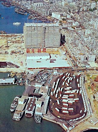
Star Ferry Pier, Tsim Sha Tsui, or Tsim Sha Tsui Ferry Pier, is a pier located on reclaimed land at the southernmost tip of Tsim Sha Tsui on Kowloon Peninsula in Hong Kong. It is commonly known as Star Ferry Pier (天星碼頭) in Tsim Sha Tsui. Star Ferry operates the pedestrian ferry service across Victoria Harbour to Wan Chai and to Central on Hong Kong Island. The location is identified as "Kowloon Point" in the franchise held by Star Ferry.

The New World Centre was a retail-hotel-residential-office complex on Salisbury Road, Tsim Sha Tsui, Kowloon, Hong Kong. It housed two hotels, two office towers, a shopping complex and serviced apartments. It was reported to be one of the largest commercial complexes in the world at the time. It used to house a Tokyu Department Store. It was located near the Sogo department store and the Hong Kong Space Museum, opposite the MTR East Tsim Sha Tsui station.
Jordan Road Ferry Pier or Ferry Point (1924–1998) is a demolished pier originally located at Jordan Road, Jordan, Hong Kong.

Granville Road is a street in Tsim Sha Tsui, Hong Kong.

Kimberley Road is a road in Tsim Sha Tsui, Kowloon, Hong Kong.

Hung Hom Ferry Pier is a ferry pier in Hung Hom, Kowloon, Hong Kong. It is at the reclaimed Hung Hom Bay at the south of Lily Mansion, Whampoa Garden.

The Tsim Sha Tsui Waterfront Revitalisation Plan is a forfeited development proposal by New World Development Co. Ltd and the Leisure and Cultural Services Department made in 2013. The aim of the plan was to reshape the waterfront by adding in activity hubs consisting of various small-scale commercial, entertainment and recreational areas in Salisbury Garden, Avenue of Stars as well as the East Tsim Sha Tsui Promenade. The plan was later dismissed by Leisure and Cultural Services Department and the Harbourfront Commission due to huge public controversies in 2016.


