The protected areas of South Africa include national parks and marine protected areas managed by the national government, public nature reserves managed by provincial and local governments, and private nature reserves managed by private landowners. Most protected areas are intended for the conservation of flora and fauna. National parks are maintained by South African National Parks (SANParks). A number of national parks have been incorporated in transfrontier conservation areas.

The Blue Mountains National Park is a protected national park that is located in the Blue Mountains region of New South Wales, in eastern Australia. The 267,954-hectare (662,130-acre) national park is situated approximately 80 kilometres (50 mi) west of Sydney, and the park boundary is quite irregular as it is broken up by roads, urban areas and inholdings. Despite the name mountains, the area is an uplifted plateau, dissected by a number of larger rivers. The highest point in the park is Mount Werong at 1,215 metres (3,986 ft) above sea level; while the low point is on the Nepean River at 20 metres (66 ft) above sea level as it leaves the park.

The Kanangra-Boyd National Park is a protected national park that is located in the Central Tablelands region, west of the Southern Highlands and Macarthur regions, in New South Wales, in eastern Australia. The 68,660-hectare (169,700-acre) national park is situated approximately 180 kilometres (110 mi) south-west of Sydney and is contiguous with the Blue Mountains National Park and the Nattai National Park. The park was established in 1969.

The Lamington National Park is a national park, lying on the Lamington Plateau of the McPherson Range on the Queensland/New South Wales border in Australia. From Southport on the Gold Coast the park is 85 kilometres (53 mi) to the southwest and Brisbane is 110 kilometres (68 mi) north. The 20,600 hectares Lamington National Park is known for its natural environment, rainforests, birdlife, ancient trees, waterfalls, walking tracks and mountain views.

The Drakensberg is the name given to the eastern portion of the Great Escarpment, which encloses the central Southern African plateau. The Great Escarpment reaches its greatest elevation in this region – 2,000 to 3,482 metres. It is located within the borders of South Africa and Lesotho.

The Balkan mountain range is a mountain range in the eastern part of the Balkan Peninsula. The Balkan range runs 557 km from the Vrashka Chuka Peak on the border between Bulgaria and Serbia eastward through central Bulgaria to Cape Emine on the Black Sea. The highest peaks of the Balkan Mountains are in central Bulgaria. The highest peak is Botev at 2,376 m, which makes the mountain range the third highest in the country, after Rila and Pirin. The mountains are the source of the name of the Balkan Peninsula.

The Brindabella Range, commonly called The Brindabellas, is a mountain range located in Australia, on a state and territory border of New South Wales and the Australian Capital Territory (ACT). The range rises to the west of Canberra, the capital city of Australia, and includes the Namadgi National Park in the ACT and the Bimberi Nature Reserve and Brindabella National Park in New South Wales. The Brindabellas are visible to the west of Canberra and form an important part of the city's landscape.

Beverley Brook is a minor English river 14.3 km (8.9 mi) long in southwest London. It rises in Worcester Park and joins the River Thames to the north of Putney Embankment at Barn Elms.
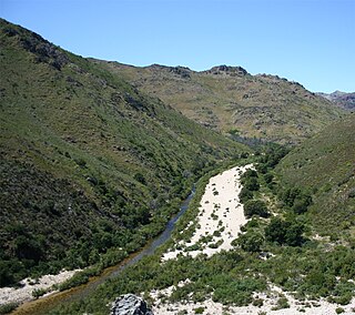
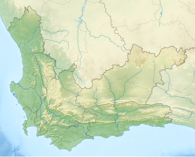
The Olifants River is a river in the northwestern area of the Western Cape Province of South Africa. The upper and main catchment area of the Olifants river is around Ceres and the Cederberg mountains. The Clanwilliam and Bulshoek dams are located on the river and provide water for the towns and farms along the watercourse. The river is approximately 285 km long with a catchment area of 46,220 km2 and flows into the Atlantic Ocean at Papendorp, 250 km north of Cape Town.

Mount Kenya National Park was established in 1949 to protect Mount Kenya, the wildlife and surrounding environment, which forms a habitat for wild animals, as well as acting as an area for the catchment of water, to supply Kenya's water.

The Selous Game Reserve is a protected area in southern Tanzania. It covers a total area of 50,000 km2 (19,000 sq mi) and has additional buffer zones. It was designated a UNESCO World Heritage Site in 1982 due to its wildlife diversity and undisturbed nature. Some of the typical wildlife of the miombo inhabits the reserve, such as African bush elephant, black rhino, hippopotamus, lion, East African wild dog, Cape buffaloes, Masai giraffe, Plains zebra, and Nile crocodile. Permanent human habitation is not permitted within the reserve. All human entry and exit is controlled by the Wildlife Division of the Tanzanian Ministry of Natural Resources and Tourism.

The Tsitsikamma National Park is a protected area on the Garden Route, Western Cape and Eastern Cape, South Africa. It is a coastal reserve well known for its indigenous forests, dramatic coastline, and the Otter Trail. On 6 March 2009 it was amalgamated with the Wilderness National Park and various other areas of land to form the Garden Route National Park.

The Palani Hills Wildlife Sanctuary and National Park is a proposed protected area in Dindigul District, Tamil Nadu India. The park will be an upgrade and expansion of the 736.87 km2(PRO) Palani (Kodaikanal) Wildlife Sanctuary which was to be established in 2008. The park includes about 36% of the 2,068 square kilometres (798 sq mi) in the Palani Hills. The park is located between latitude 10°7' - 10°28' N and longitude 77°16' - 77°46' E. Central location is 1.5 kilometres (0.93 mi) east northeast of Silver Cascade Waterfall and 4 kilometres (2.5 mi) E X NE of Kodaikanal Lake.

The wildlife of Botswana refers to the flora and fauna of Botswana. Botswana is around 90% covered in savanna, varying from shrub savanna in the southwest in the dry areas to tree savanna consisting of trees and grass in the wetter areas. Even under the hot conditions of the Kalahari Desert, many different species survive; in fact the country has more than 2500 species of plants and 650 species of trees. Vegetation and its wild fruits are also extremely important to rural populations living in the desert and are the principal source of food, fuel and medicine for many inhabitants.
The Gaoligong Mountains,, are a mountainous sub-range of the southern Hengduan Mountain Range, located in the western Yunnan highlands and straddling the border of southwestern China and northern Myanmar (Burma).

Bắc Kạn, also spelt Bắc Cạn, is a province of Vietnam. It is located in the Northeast region, due north of the capital Hanoi. Bắc Kạn is the only town of the province which is the capital of the province and is a municipality. The province covers an area of 4,859.4 square kilometres and as of 2008 it had a population of 308,900 people. It is a mountainous terrain with rich natural resources of minerals and forests. It has numerous mountains, rivers and lakes which are very scenic. Ba Bể National Park and Ba Bể Lake lie within its borders.

Many areas of Vietnam are under protection. While the national reserves cover small areas of scientific significance with restricted access, the national parks also cover wetlands of Ramsar designated areas and BirdLife International inscribed bird areas. The largest of the national parks initially covered were the Cúc Phương National Park, the Cát Tiên National Park, and the Côn Đảo National Park which to start with were forest areas cum reserves or prohibited areas. The objective for creating national parks was to allow access to the reserved areas as a part of ecotourism and cultural needs with full attention to the basic approach of conservation of natural environmental resources.

The protected areas of Namibia include its national parks and reserves. With the 2010 declaration of Dorob National Park, Namibia became the first and only country to have its entire coastline protected through a national parks network. Protected areas are subdivided into game reserves and/or nature reserves, such as special protected area, wilderness areas, natural areas, and development areas. There are also recreation reserves. Facilities in the national parks are operated by Namibia Wildlife Resorts. Over 19% of Namibia is protected, an area of some 130,000 square kilometres. However, the Ministry of Environment & Tourism auctions limited hunting rights within its protected areas. The Namibia Nature Foundation, an NGO, was established in 1987 to raise and administer funds for the conservation of wildlife and protected area management. Communal Wildlife Conservancies in Namibia help promote sustainable natural resource management by giving local communities rights to wildlife management and tourism.

The Buchan River is a perennial river of the Snowy River catchment, located in the Alpine region of the Australian state of Victoria.

Shorsky National Park is a forested, mountainous area in southwestern Siberia, where the West Siberian Plain meets the South Siberian Mountains. It is representative of areas with dark taiga tree cover. With an area of 1,614 square miles (4,180 km2), the park covers over a third of Tashtagolsky District at the southern end of Kemerovo Oblast, about 300 kilometres (190 mi) south of the city of Kemerovo. The area is the home of the Shors people, and has historically been associated with mining and logging industries before being established as a protected area in 1989.