The Serengeti National Park is a large national park in northern Tanzania that stretches over 14,763 km2 (5,700 sq mi). It is located in eastern Mara Region and northeastern Simiyu Region and contains over 1,500,000 hectares of virgin savanna. The park was established in 1940.

The mountain zebra is a zebra species in the family Equidae, native to southwestern Africa. There are two subspecies, the Cape mountain zebra found in South Africa and Hartmann's mountain zebra found in south-western Angola and Namibia.

The Samburu National Reserve is a game reserve on the banks of the Ewaso Ng'iro river in Kenya. On the other side of the river is the Buffalo Springs National Reserve. The park is 165 km² in size and is situated 350 kilometers from Nairobi. It ranges in altitude from 800 to 1230 m above sea level. Geographically, it is located in Samburu County.

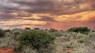
The Karoo is a semi-desert natural region of South Africa. No exact definition of what constitutes the Karoo is available, so its extent is also not precisely defined. The Karoo is partly defined by its topography, geology and climate, and above all, its low rainfall, arid air, cloudless skies, and extremes of heat and cold. The Karoo also hosted a well-preserved ecosystem hundreds of million years ago which is now represented by many fossils.

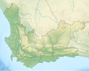
Tankwa Karoo National Park is a national park in South Africa. The park lies about 70 km due west of Sutherland near the border of the Northern Cape and Western Cape, in one of the most arid regions of South Africa, with areas receiving less than 100 mm of average annual precipitation, moisture-bearing clouds from the Atlantic Ocean being largely stopped by the Cederberg mountains. Other low areas receive little more, as the Roodewerf station with 180 mm of mean annual rainfall. In the hottest areas of the park, the mean maximum temperature in January is 38.9 °C, and in July the mean minimum temperature ranges from about 5 to 7 °C. Before this Park's proclamation, the only protected area of Succulent Karoo was the 2 square kilometre patch of the Gamkaberg Nature Reserve. Succulent Karoo has, together with the Cape Floral Kingdom, been declared a Biodiversity Hotspot by Conservation International.

Helderberg refers to a planning district of the City of Cape Town metropolitan municipality, the mountain after which it is named, a wine-producing area in the Western Cape province of South Africa, or a small census area in Somerset West.

The Cape mountain zebra is a subspecies of mountain zebra that occurs in certain mountainous regions of the Western and Eastern Cape provinces of South Africa.
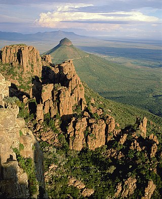
The Camdeboo National Park is located in the Karoo and almost completely surrounds the Eastern Cape town of Graaff-Reinet. It contains the Nqweba Dam.
Mokala National Park is a reserve established in the Plooysburg area south-west of Kimberley in the Northern Cape, South Africa on 19 June 2007. The size of the park is 26,485 hectares. Mokala is the Setswana name for the magnificent camel thorn, a tree species typical of the arid western interior and common in the area. There is currently 70 km of accessible roads in the national park.

The Outeniqua Mountains, named after the Outeniqua Khoikhoi who lived there, is a mountain range that runs a parallel to the southern coast of South Africa, and forms a continuous range with the Langeberg to the west and the Tsitsikamma Mountains to the east. It was known as Serra de Estrella to the Portuguese. The mountains are part of the Garden Route of South Africa.
Mpofu Nature Reserve is a nature reserve in the Amatole district of the Eastern Cape Province, South Africa that is managed by Eastern Cape Parks.
Tsolwana Nature Reserve is an 8,500 hectare nature reserve situated on the edge of the Winterberg Mountain range. It is located 60 km west of Queenstown, and 30 km south- east of Tarkastad in Eastern Cape Province, South Africa and is managed by Eastern Cape Parks Board. Its western boundary is formed by the upper Black Kei River. The reserve's name originates from the Xhosa word for "spike", due to the presence of the cone-shaped hill, Spitskop.

Renosterveld is a term used for one of the major plant communities and vegetation types of the Cape Floristic Region which is located in southwestern and southeastern South Africa, in southernmost Africa. It is an ecoregion of the Mediterranean forests, woodlands, and scrub biome.

Balule Nature Reserve is a protected area in Limpopo Province, South Africa which forms part of the Greater Kruger National Park as a member of the Associated Private Nature Reserves (APNR). As part of a wildlife conservation initiative, all fences separating APNR reserves – Balule, Timbavati, Klaserie, Umbabat, Grietjie Private Nature Reserve – and the Kruger National Park have been removed.

Kogelberg Nature Reserve is a nature reserve of 3,000 ha comprising the Kogelberg Mountain Range, to the east of Cape Town, South Africa.
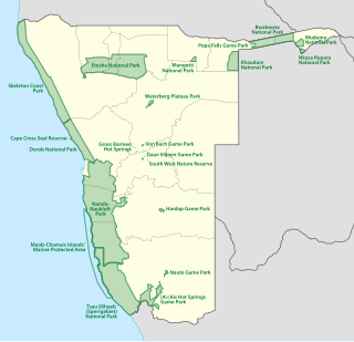
The protected areas of Namibia include its national parks and reserves. With the 2010 declaration of Dorob National Park, Namibia became the first and only country to have its entire coastline protected through a national parks network. Protected areas are subdivided into game reserves and/or nature reserves, such as special protected area, wilderness areas, natural areas, and development areas. There are also recreation reserves. Facilities in the national parks are operated by Namibia Wildlife Resorts. Over 19% of Namibia is protected, an area of some 130,000 square kilometres. However, the Ministry of Environment & Tourism auctions limited hunting rights within its protected areas. The Namibia Nature Foundation, an NGO, was established in 1987 to raise and administer funds for the conservation of wildlife and protected area management. Communal Wildlife Conservancies in Namibia help promote sustainable natural resource management by giving local communities rights to wildlife management and tourism.
The Kammanassie Mountains are a mountain range in the Western Cape, South Africa. The highest peak is Mannetjiesberg at 1,955 metres above sea level and the mountain range is one of the prominent east-west trending ranges composing the southern branch of the Cape Fold Belt.
The Matjiesrivier Nature Reserve is a nature reserve located in the north of the Western Cape province, close to the Cederberg Nature Reserve which borders its northwestern limit. It is part of the Cape Floral Kingdom ecosystem and is one of the Cape Floral Region Protected Areas.