
Appleton Wiske is a small village and civil parish that sits between Northallerton and Yarm in the Vale of York, a flat tract of land that runs between the North Yorkshire Moors to the east, the Yorkshire Dales to the west and the River Tees to the north.

Helmsley is a market town and civil parish in the Ryedale district of North Yorkshire, England. Historically part of the North Riding of Yorkshire, the town is located at the point where Ryedale leaves the moorland and joins the flat Vale of Pickering.

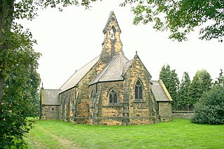
Cherry Burton is a village and civil parish in the East Riding of Yorkshire, England. It is approximately 3 miles (5 km) north-west of the market town of Beverley, 9 miles (14 km) east of Market Weighton and 11 miles (18 km) south west of Driffield. The village lies on the eastern edge of the Yorkshire Wolds and lies to the west of the B1248 road.

Harpham is a small village and civil parish in the East Riding of Yorkshire, England. It is located just south of the A614 road, approximately 5 miles (8 km) north-east of Driffield and 7 miles (11 km) south-west of Bridlington.
Whitley is a village in the Selby district of North Yorkshire, England, close to the Aire and Calder Navigation and the M62 motorway. The population of the village at the 2001 census was recorded as being 574, which had risen to 1,021 by the time of the 2011 census. In 2015, North Yorkshire County Council estimated the population to have risen again to 1,110. It was historically part of the West Riding of Yorkshire until 1974.

Gate Helmsley is a village and civil parish in the Ryedale district of North Yorkshire, England, about seven miles east of York. The village lies on the border with the East Riding of Yorkshire.

Kirby Sigston is a village and civil parish in the Hambleton district of North Yorkshire, England, approximately 4 miles (6.4 km) east of Northallerton. The village is situated on the Cod Beck river, and the wider parish contains the hamlet of Jeater Houses due east of the village on the trunk A19 road. The village is mentioned in the Domesday Book of 1086 as having 75 ploughlands, and its name derives from a combination of the Old Norse Kirkju-býr and Sigges tūn. Sigston is also the name of a village nearby.

Wrelton is a village and civil parish in the Ryedale district of North Yorkshire, England. It is on the A170 road and 2 miles west of Pickering.

Stonegrave is a village and civil parish in the Ryedale district of North Yorkshire, England. At the 2011 Census the population was less than 100 and so the details are included in the civil parish of Nunnington. By 2015, North Yorkshire County Council estimated the population as 110. It is situated in the Howardian Hills Area of Outstanding Natural Beauty (AONB) and 5 miles (8 km) south east of Helmsley on the Helmsley to Malton road.

Flixton is a village in the Scarborough district of North Yorkshire, England. Until 1974 the village lay in the historic county boundaries of the East Riding of Yorkshire. There is a public house, the Foxhound Inn.

Weaverthorpe is a village and civil parish in the Ryedale district of North Yorkshire, England. It is 13 miles (21 km) south-west of Scarborough.

Helperthorpe is a village in the Ryedale district of North Yorkshire, England. The village lies in the Great Wold Valley and the course of the winterbourne stream the Gypsey Race passes through it.
Edstone is a civil parish in the Ryedale district of the county of North Yorkshire, England, the principal settlement in which is the village of Great Edstone. Edstone has a population of 217 according to the 2011 census.

Gillamoor is a village and civil parish in the Ryedale district of the county of North Yorkshire, England. It is situated about 3 miles (5 km) north of Kirkbymoorside on the edge of the North York Moors National Park. The population of the parish as taken at the 2001 census was 168, dropping to 156 at the 2011 census was 156. In 2015, North Yorkshire County Council estimated the population of the parish to be 150 people.

Foxholes is a village in the Ryedale district of North Yorkshire, England, part of the civil parish of Foxholes with Butterwick. It lies where the B1249 road crosses the Great Wold Valley, 9 miles (14.5 km) south from Scarborough, 11 miles (17.7 km) north-west from Bridlington, and 7 miles (11.3 km) north-east from Sledmere. The course of the winterbourne stream the Gypsey Race passes to the south of the village.

Sawdon is a village in the civil parish of Brompton in the Scarborough district of North Yorkshire, England, about 8 miles (13 km) west of Scarborough. As the population is less than 100, details are included in the data for Brompton Parish.

Scawton is a village and former civil parish in Ryedale, North Yorkshire, England. The hamlet lies just east of Sutton Bank, north of the A170 road, and 5 miles (8 km) west of Helmsley, in the Hambleton Hills. The wider parish was the setting for the Battle of Old Byland, on Scawton Moor to the south. The road through the village used to link the two abbeys at Byland and Rievaulx, with the church, and possibly the village pub, being instigated by the monks for the use of travellers. In 1961 the parish had a population of 84.

Lillings Ambo is a civil parish in the Ryedale district of North Yorkshire, England. It is between the villages of Strensall and Sheriff Hutton, and its southern edge is the border between Ryedale and the City of York Unitary Authority. The River Foss flows through the parish, and in 2020, a scheme was approved to build a leaky dam to store water in the south of the parish in times of flood.

Marishes is a civil parish in the Ryedale district of North Yorkshire, England. The parish has an area of some 2,960 acres, and is located between Malton and Pickering in the low-lying Vale of Pickering. Whilst the main occupation of the residents in the parish is agricultural in nature, the area is known for its onshore gas field. In 2015, the population of the parish was estimated to be 140.

Henderskelfe is a civil parish in North Yorkshire, England. The parish does not contain any villages, though it is named after a previous settlement and castle which occupied the land on which Castle Howard is now built. Historically the area was a township in the ecclesiastical parish of Bulmer, however it has been its own civil parish since 1866.

