The Franconian Saale is a 140 km long river in Bavaria, Germany. It is a right-bank tributary of the Main, in Lower Franconia. It should not be confused with the larger Saxon Saale, which is a tributary of the Elbe River.

The term Kaiserpfalz or Königspfalz refers to a number of castles and palaces across the Holy Roman Empire that served as temporary, secondary seats of power for the Holy Roman Emperor in the Early and High Middle Ages. The term was also used more rarely for a bishop who, as a territorial lord (Landesherr), had to provide the king and his entourage with board and lodging, a duty referred to as Gastungspflicht.

Bad Neustadt an der Saale, officially Bad Neustadt a. d. Saale and often simply called Bad Neustadt, is a town in northern Bavaria, Germany. It is the capital of the Rhön-Grabfeld district in Lower Franconia. It is situated on the rivers Fränkische Saale and Brend, near the Rhön Mountains, 30 km north of Schweinfurt, and 47 km southeast of Fulda.

Neustadt an der Orla is a town in Saale-Orla-Kreis district, in Thuringia. It is situated at the small river Orla, 17 km north of Schleiz, and 25 km southeast of Jena. The former municipality Stanau was merged into Neustadt an der Orla in January 2019, and Linda bei Neustadt an der Orla, Knau and Dreba in December 2019.

Bad Bocklet is a municipality in the district of Bad Kissingen in Bavaria in Germany. It is a market town and a health spa.
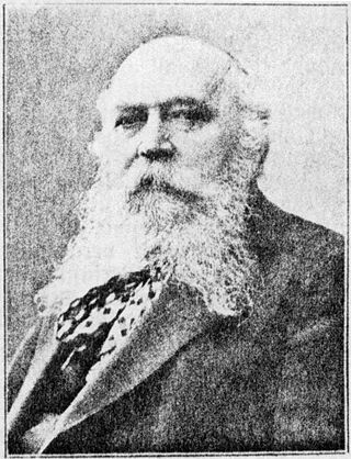
Anton Memminger (1846–1923) was a German author, publisher and politician. In his Swiss period he used the alias "Oswald Stein".

Bergfried is a tall tower that is typically found in castles of the Middle Ages in German-speaking countries and in countries under German influence. Friar describes it as a "free-standing, fighting-tower". Its defensive function is to some extent similar to that of a keep in English or French castles. However, the characteristic difference between a bergfried and a keep is that a bergfried was typically not designed for permanent habitation.

An imperial castle or Reichsburg was a castle built by order of the Holy Roman Emperor, whose management was entrusted to Reichsministeriales or Burgmannen. It is not possible to identify a clear distinction between imperial castles and the fortified imperial palaces or Pfalzen, because many imperial castles were used by German kings for temporary stays. Many imperial castles were built in regions such as Swabia, Franconia, the Palatinate and the Alsace, where there were a high density of imperial estates (Reichsgüter) during the Hohenstaufen era.
Klopp Castle is a castle in the town of Bingen am Rhein in the Upper Middle Rhine Valley in Rhineland-Palatinate, Germany. In the nineteenth century, the bergfried from the original medieval fortified castle was restored and a new building added which houses the town's administration.

Erfenstein Castle is a medieval spur castle in the German state of Rhineland-Palatinate. It lies within the Palatine Forest above the Elmstein Valley at 265 m above sea level (NN) in the vicinity of the hamlet of Erfenstein in the municipality of Esthal. Together with nearby Spangenberg Castle, it is linked to the legend of the Leather Bridge.
A Ganerbenburg is a castle occupied and managed by several families or family lines at the same time. These families shared common areas of the castle including the courtyard, well, and chapel, whilst maintaining their own private living quarters. They occurred primarily in medieval Germany.

The ruins of Werdenfels Castle stand about 80 metres above the Loisach valley between Garmisch and Farchant in the county of Garmisch-Partenkirchen in Upper Bavaria. The spur castle was used until 1632 as the administrative centre of the County of Werdenfels, but began to fall into disrepair thereafter.

The Royal Palace of Werla is located near Werlaburgdorf in Lower Saxony. The grounds of the royal palace cover about 20 hectares rising atop Kreuzberg hill, a 17 m high natural plateau overlooking the Oker river. In the Early Middle Ages the palace was an important place in the Holy Roman Empire, serving as an important base for the Ottonians in the 10th century in particular. Although it subsequently lost its political significance to the newly established Imperial Palace of Goslar at Rammelsberg, it developed into an independent settlement with a busy industrial quarter. In the 14th century it fell into ruin and was completely unknown until its rediscovery in the 18th century. The core fortress in particular was thoroughly excavated in the 20th century. Excavations carried out since 2007 have brought new understanding to the hitherto largely unexplored outworks. Since 2010 the palace complex with foundation and enceinte, as well as earthworks, has been partially reconstructed and is now open to the public as the Archäologie- und Landschaftspark Kaiserpfalz Werla.

Hohenfreyberg Castle, together with Eisenberg Castle directly opposite, forms a castle group in the southern Allgäu that is visible from a long way off. It is located about four kilometres north of Pfronten in the county of Ostallgäu. The late mediaeval hilltop castle was abandoned during the Thirty Years’ War and set on fire. From 1995 to 2006 the former aristocratic seat was comprehensively made safe and conserved as part of a closely observed "example of renovation".

The Rauschenburg, also called Rauschenburg Castle, is the medieval ruin of a hill castle, located at around 250 metres above sea level, above the Ehrbach stream in the parish of Mermuth in the county of Rhein-Hunsrück-Kreis in the German state of Rhineland-Palatinate.

Neideck Castle is a former high mediaeval nobleman's castle above the village of Streitberg, in the municipality of Wiesenttal in the Upper Franconian county of Forchheim in the German state of Bavaria. As a result of its exposed location above the valley of the Wiesent, it has become a symbol of Franconian Switzerland.

Waischenfeld Castle is a ruined rock castle on a rocky plateau a few metres west of the town of Waischenfeld in the province of Upper Franconia in the German state of Bavaria.

Thuisbrunn Castle is located centrally within the parish of Thuisbrunn in the municipality of Gräfenberg in the Bavarian province of Upper Franconia. After having been destroyed and rebuilt several times, the castle is now in private ownership.
Wildenberg Castle, also called the Wildenburg, is a ruined, Hohenstaufen period castle in the Odenwald hills in Germany. It is located in the parish of Preunschen in the municipality of Kirchzell, in the Lower Franconian district of Miltenberg in Bavaria.