San Bernardino, Switzerland

Last updated

San Bernardino.jpg

San Bernardino is a mountainous village in the canton of Grisons in Switzerland. It is the southern entry point to the San Bernardino tunnel, which complemented the road over the San Bernardino Pass in 1967, opening a new all-year-round road to crossing the Alps.

Contents

The village is part of the municipality of Mesocco. The language spoken is Italian, one of the three official languages in the canton of Graubünden.

The church dates from around 1450, only years before the Viamala gorge bridge was opened for traffic, multiplying traffic across the pass.

Traffic

Lagh Doss Lago Dosso.jpg
Lagh Doss

The old Mulattiera is still visible and in good condition, this was the path for horses before the construction of a road in 1770 by the adjacent municipalities. In 1812 the state (or canton) of Graubünden built a new road that is actually the one still in use for local traffic and across the pass, whereas the tunnel traffic uses a newly built road that avoids serpentines to allow a fluent traffic.

The walls were built then as dry walls and were restored in 1995 because the road has still to work as a replacement for the tunnel if it has to be closed. The restoration was completed with a minimum amount of concrete reinforcements. [1]

Geography

Aerial view (1953) ETH-BIB-San Bernardino-LBS H1-015888.tif
Aerial view (1953)

Lagh Doss is located close to the village. The municipality encloses Val Curciusa, a valley lying north of Bocchetta di Curciusa and therefore emptying its waters towards the Rhine river and the North Sea instead of the Adriatic Sea as in most Italian spoken areas of the canton of Graubünden.

Weather

Climate data for S. Bernardino: 1638m (1991–2020)
MonthJanFebMarAprMayJunJulAugSepOctNovDecYear
Average high °C (°F)0.7
(33.3)
1.0
(33.8)
3.7
(38.7)
6.8
(44.2)
11.5
(52.7)
15.9
(60.6)
18.2
(64.8)
17.8
(64.0)
13.4
(56.1)
9.2
(48.6)
4.1
(39.4)
1.3
(34.3)
8.6
(47.5)
Daily mean °C (°F)−3.4
(25.9)
−3.1
(26.4)
−0.3
(31.5)
2.7
(36.9)
7.0
(44.6)
11.2
(52.2)
13.2
(55.8)
12.9
(55.2)
9.0
(48.2)
5.0
(41.0)
0.4
(32.7)
−2.6
(27.3)
4.3
(39.7)
Average low °C (°F)−7.3
(18.9)
−7.1
(19.2)
−4.2
(24.4)
−1.1
(30.0)
2.9
(37.2)
6.7
(44.1)
8.6
(47.5)
8.6
(47.5)
5.1
(41.2)
1.4
(34.5)
−2.7
(27.1)
−6.1
(21.0)
0.4
(32.7)
Average precipitation mm (inches)77
(3.0)
60
(2.4)
81
(3.2)
133
(5.2)
168
(6.6)
172
(6.8)
159
(6.3)
187
(7.4)
162
(6.4)
181
(7.1)
168
(6.6)
88
(3.5)
1,637
(64.4)
Average snowfall cm (inches)100
(39)
82
(32)
77
(30)
92
(36)
14
(5.5)
1
(0.4)
0
(0)
0
(0)
1
(0.4)
10
(3.9)
69
(27)
91
(36)
537
(211)
Average precipitation days (≥ 1.0 mm)7.66.58.110.114.112.512.012.710.011.110.78.5123.9
Average snowy days (≥ 1.0 cm)8.77.77.87.81.80.10.00.00.21.67.08.951.6
Average relative humidity (%)66636671737272757777746871
Mean monthly sunshine hours 9710714112812814516315413310981861,470
Percent possible sunshine 54565244404449504948455148
Source: MeteoSwiss (snow 1981–2010) [2] [3]

Related Research Articles

<span class="mw-page-title-main">Altdorf, Uri</span> Municipality in Uri, Switzerland

Altdorf is a municipality in Switzerland. It is the capital of the Swiss canton of Uri and retains historic town privileges. It is the place where, according to the legend, William Tell shot the apple from his son's head.

<span class="mw-page-title-main">A13 motorway (Switzerland)</span>

The A13 is a motorway, at times an Autostrasse (expressway), which runs from St. Margrethen in northeastern Switzerland through to Ascona in southern Switzerland, crossing the main chain of the Alps in the Grisons area. It is the southern half of European route E43.

<span class="mw-page-title-main">San Bernardino Tunnel</span> Tunnel in Switzerland

The San Bernardino road tunnel is a road tunnel in the canton of Graubünden in south-eastern Switzerland. It runs under the San Bernardino Pass between the town of San Bernardino and the town of Hinterrhein, and forms part of the A13 motorway and the European route E43. The tunnel was completed in 1967 and is 6,596 metres (21,640 ft) long. Since the opening of the tunnel, the Val Mesolcina, one of the Italian-speaking southern valleys of Graubünden, is now connected all-year round with the rest of the canton.

<span class="mw-page-title-main">Grimsel Pass</span> Mountain pass in Switzerland through the Bernese Alps

The Grimsel Pass is a mountain pass in Switzerland, crossing the Bernese Alps at an elevation of 2,164 metres (7,100 ft). The pass connects the Haslital, the upper valley of the river Aare, with the upper valley of the Rhône. In so doing, and as the Aare is a tributary of the Rhine, the pass crosses the continental divide between the North Sea and the Mediterranean Sea.

<span class="mw-page-title-main">Andermatt</span> Municipality in Uri, Switzerland

Andermatt is a mountain village and municipality in the canton of Uri in Switzerland. At an elevation of 1,437 meters (4,715 ft) above sea level, Andermatt is located at the center of the Saint-Gotthard Massif and the historical center cross of north-south and east-west traverses of Switzerland. It is some 28 km (17 mi) south of Altdorf, the capital of Uri.

<span class="mw-page-title-main">Bernina Pass</span> Mountain pass in Graubünden, Switzerland

The Bernina Pass is a high mountain pass in the Bernina Range of the Alps, in the canton of Graubünden (Grisons) in eastern Switzerland. It connects the famous resort town of St. Moritz in the Engadin valley with the Italian-speaking Val Poschiavo, which ends in the Italian town of Tirano in Valtellina. The pass lies a few kilometres east of Piz Bernina, and south of Val Minor.

<span class="mw-page-title-main">San Bernardino Pass</span> Mountain pass in the Swiss Alps

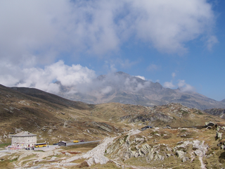
San Bernardino Pass is a high mountain pass in the Swiss Alps connecting the Hinterrhein and the Mesolcina (Misox) valleys between Thusis and Bellinzona. Located in the far eastern side of the Western Alps it is not to be confused with the Great St Bernard Pass and the Little St Bernard Pass. The top of the pass represents both the Italo-German language frontier and the watershed between the Po basin and the Rhine basin. Marscholsee is within the pass at an elevation of 2,053 m (6,736 ft).

<span class="mw-page-title-main">Disentis</span> Municipality in Grisons, Switzerland

Mustér or Disentis (German)(, Romansh), with its official name Disentis/Mustér is a village and a municipality in the Surselva Region in the Swiss canton of Grisons.

<span class="mw-page-title-main">Poschiavo</span> Municipality in Grisons, Switzerland

Poschiavo is a municipality in the Bernina Region in the canton of Grisons in Switzerland.

<span class="mw-page-title-main">Ulrichen</span> Former municipality in Valais, Switzerland

Ulrichen is a village in the municipality of Obergoms in the district of Goms in the canton of Valais in Switzerland. The population was 219.

<span class="mw-page-title-main">Andeer</span> Municipality in Graubünden, Switzerland

Andeer is a municipality in the Viamala Region in the Swiss canton of Graubünden. In 2009 Clugin and Pignia merged into Andeer.

<span class="mw-page-title-main">Hinterrhein, Switzerland</span> Municipality in Graubünden, Switzerland

Hinterrhein is a village and a former municipality in the Viamala Region in the Swiss canton of Graubünden. The village is located near the start of the river Hinterrhein/Rein Posteriur, one of the two initial tributaries of the Rhine. On 1 January 2019 the former municipalities of Hinterrhein, Nufenen and Splügen merged to form the new municipality of Rheinwald.

<span class="mw-page-title-main">Tujetsch</span> Municipality in Graubünden, Switzerland

Tujetsch is a municipality in the Surselva Region in the canton of Graubünden in Switzerland. It is the westernmost municipality of the canton, connected to Urseren by the Oberalp Pass.

Grono is a municipality in the Moesa Region in the Italian speaking part of the Swiss canton of Grisons. On 1 January 2017 the former municipalities of Leggia and Verdabbio merged into the municipality of Grono.

<span class="mw-page-title-main">Mesocco</span> Municipality in Graubünden, Switzerland

Mesocco is a municipality in the Moesa Region in the Swiss canton of Graubünden.

<span class="mw-page-title-main">Einshorn</span> Mountain in Switzerland

The Einshorn is a mountain of the Lepontine Alps, overlooking Hinterrhein in the Swiss canton of Graubünden.

<span class="mw-page-title-main">Gambarogno</span> Municipality in Ticino, Switzerland

Gambarogno is a municipality in the district of Locarno in the canton of Ticino in Switzerland. It was created on 25 April 2010 through the merger of the municipalities of Caviano, Contone, Gerra, Indemini, Magadino, Piazzogna, San Nazzaro, Sant'Abbondio and Vira.

<span class="mw-page-title-main">Val Vignun</span>

The Val Vignun is an alpine valley in the Swiss Canton of Graubünden. It also forms a connection between the Misox valley and the Rheinwald valley, parallel to the San Bernardino Pass.

Munt Buffalora is a mountain of the Ortler Alps, located south of the Ofen Pass in the Swiss canton of Graubünden.

<span class="mw-page-title-main">Rheinwald, Switzerland</span> Municipality in Graubünden, Switzerland

Rheinwald is a municipality in the Viamala Region in the Swiss canton of Graubünden. On 1 January 2019 the former municipalities of Hinterrhein, Nufenen and Splügen merged to form the new municipality of Rheinwald.

References

  1. Historic Road dating 1812 being restored (german) Archived 7 July 2011 at the Wayback Machine
  2. "Climate Normals S. Bernardino (Reference period 1991−2020)" (PDF). Swiss Federal Office of Meteorology and Climatology, MeteoSwiss. Retrieved 29 January 2022.
  3. "Climate Normals S. Bernardino (Reference period 1981−2010)" (PDF). Swiss Federal Office of Meteorology and Climatology, MeteoSwiss. Retrieved 29 January 2022.

46°27′N9°12′E / 46.450°N 9.200°E / 46.450; 9.200