Related Research Articles

St. Simons Island is a barrier island and census-designated place (CDP) located on St. Simons Island in Glynn County, Georgia, United States. The names of the community and the island are interchangeable, known simply as "St. Simons Island" or "SSI", or locally as "The Island". St. Simons is part of the Brunswick metropolitan statistical area, and according to the 2020 U.S. census, the CDP had a population of 14,982. Located on the southeast Georgia coast, midway between Savannah and Jacksonville, St. Simons Island is both a seaside resort and residential community. It is the largest of Georgia's renowned Golden Isles. Visitors are drawn to the Island for its warm climate, beaches, variety of outdoor activities, shops and restaurants, historical sites, and natural environment.

San Juan del Puerto was a Spanish Franciscan mission founded before 1587 on Fort George Island, near the mouth of the St. Johns River in what is now Jacksonville, Florida. It was founded to serve the Saturiwa, a Timucua tribe who lived around the mouth of the St. Johns. It was organized by separating them into nine smaller villages. It has an important place in the study of the Timucua, as the place where Francisco Pareja undertook his work on the Timucua language.
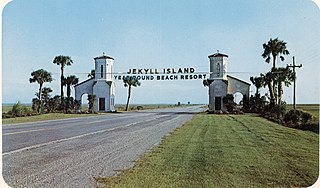
Jekyll Island is located off the coast of the U.S. state of Georgia, in Glynn County. It is one of the Sea Islands and one of the Golden Isles of Georgia barrier islands. The island is owned by the State of Georgia and run by a self-sustaining, self-governing body.
The Potano tribe lived in north-central Florida at the time of first European contact. Their territory included what is now Alachua County, the northern half of Marion County and the western part of Putnam County. This territory corresponds to that of the Alachua culture, which lasted from about 700 until 1700. The Potano were among the many tribes of the Timucua people, and spoke a dialect of the Timucua language.
Utinahica was a town that was the site of a Spanish mission, Santa Isabel de Utinahica. It may have been the chief town of a Timucua tribe and chiefdom in the 17th century, but Hann says there is not enough known about it to be sure. The name means "lord's village". Utinahica, was called a "province" in one Spanish report. It was 30 leagues east of Arapaha, and 50 leagues northeast of the town of Tarihica in the Northern Utina Province. It was at or near where the Oconee and Ocmulgee rivers join to form the Altamaha River. The people of Utinahica apparently practiced a regional variant of the Lamar regional culture, unusual for a Timucuan-speaking people. Worth identifies the province of Utinahica with archaeological sites, including the Lind Landing site, Coffee Bluff site, and Bloodroot site, that have yielded artifacts of the Square Ground Lamar culture from before the 15th century until the middle of the 17th century. The Square Ground Lamar culture is otherwise associated with sites occupied by speakers of Muskogean languages. Archaeological sites identified with all other known Timucuan-speakers, with the possible exception of Guadalquini, do not have affinities with the Square Ground Lamar culture.

The Mocama were a Native American people who lived in the coastal areas of what are now northern Florida and southeastern Georgia. A Timucua group, they spoke the dialect known as Mocama, the best-attested dialect of the Timucua language. Their heartland extended from about the Altamaha River in Georgia to south of the mouth of the St. John's River, covering the Sea Islands and the inland waterways, Intracoastal. and much of present-day Jacksonville. At the time of contact with Europeans, there were two major chiefdoms among the Mocama, the Saturiwa and the Tacatacuru, each of which evidently had authority over multiple villages. The Saturiwa controlled chiefdoms stretching to modern day St. Augustine, but the native peoples of these chiefdoms have been identified by Pareja as speaking Agua Salada, which may have been a distinct dialect.

Beginning in the second half of the 16th century, the Kingdom of Spain established a number of missions throughout La Florida in order to convert the Native Americans to Roman Catholicism, to facilitate control of the area, and to obstruct regional colonization by other Protestants, particularly, those from England and France. Spanish Florida originally included much of what is now the Southeastern United States, although Spain never exercised long-term effective control over more than the northern part of what is now the State of Florida from present-day St. Augustine to the area around Tallahassee, southeastern Georgia, and some coastal settlements, such as Pensacola, Florida. A few short-lived missions were established in other locations, including Mission Santa Elena in present-day South Carolina, around the Florida peninsula, and in the interior of Georgia and Alabama.
The Spanish missions in Georgia comprised a series of religious outposts established by Spanish Catholics in order to spread the Christian doctrine among the Guale and various Timucua peoples in southeastern Georgia.
The Surruque people lived along the middle Atlantic coast of Florida during the 16th and 17th centuries. They may have spoken a dialect of the Timucua language, but were allied with the Ais. The Surruque became clients of the Spanish government in St. Augustine, but were not successfully brought into the Spanish mission system.
San Lorenzo de Ibihica was a Spanish Franciscan mission built in the early 17th century in the southeast of the present-day U.S. state of Georgia. It was part of Spain's effort to colonize the region of Spanish Florida and convert the Timucua to Catholicism. It served the Ibi people, also known as the Yui or Ibihica, a Timucua group of the area.
Mission San Pedro de Mocama was a Spanish colonial Franciscan mission on Cumberland Island, on the coast of the present-day U.S. state of Georgia, from the late 16th century through the mid-17th century. It was built to serve the Tacatacuru, a Mocama Timucua people.
Santa Catalina de Guale (1602-1702) was a Spanish Franciscan mission and town in Spanish Florida. Part of Spain's effort to convert the Native Americans to Catholicism, Santa Catalina served as the provincial headquarters of the Guale mission province. It also served various non-religious functions, such as providing food and labor for the colonial capital of St. Augustine. The mission was located on St. Catherines Island from 1602 to 1680, then on Sapelo Island from 1680 to 1684, and finally on Amelia Island from 1684 to 1702.
Acuera was the name of both an indigenous town and a province or region in central Florida during the 16th and 17th centuries. The indigenous people of Acuera spoke a dialect of the Timucua language. In 1539 the town first encountered Europeans when it was raided by soldiers of Hernando de Soto's expedition. French colonists also knew this town during their brief tenure (1564–1565) in northern Florida.
Francisco Pareja, OFM was a Franciscan missionary in Spanish Florida, where he was primarily assigned to Mission San Juan del Puerto. The Spaniard became a spokesman for the Franciscan community to the Spanish and colonial governments, was a leader among the missionaries, and served as custodio for the community in Florida. After the Franciscan organization was promoted to a provincia (province), Pareja was elected by his fellow missionaries as provincial in 1616.
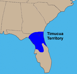
The Timucua were a Native American people who lived in Northeast and North Central Florida and southeast Georgia. They were the largest indigenous group in that area and consisted of about 35 chiefdoms, many leading thousands of people. The various groups of Timucua spoke several dialects of the Timucua language. At the time of European contact, Timucuan speakers occupied about 19,200 square miles (50,000 km2) in the present-day states of Florida and Georgia, with an estimated population of 200,000. Milanich notes that the population density calculated from those figures, 10.4 per square mile (4.0/km2) is close to the population densities calculated by other authors for the Bahamas and for Hispaniola at the time of first European contact. The territory occupied by Timucua speakers stretched from the Altamaha River and Cumberland Island in present-day Georgia as far south as Lake George in central Florida, and from the Atlantic Ocean west to the Aucilla River in the Florida Panhandle, though it reached the Gulf of Mexico at no more than a couple of points.
The Saturiwa were a Timucua chiefdom centered on the mouth of the St. Johns River in what is now Jacksonville, Florida. They were the largest and best attested chiefdom of the Timucua subgroup known as the Mocama, who spoke the Mocama dialect of Timucuan and lived in the coastal areas of present-day northern Florida and southeastern Georgia. They were a prominent political force in the early days of European settlement in Florida, forging friendly relations with the French Huguenot settlers at Fort Caroline in 1564 and later becoming heavily involved in the Spanish mission system.

The Agua Dulce or Agua Fresca (Freshwater) were a Timucua people of northeastern Florida. They lived in the St. Johns River watershed north of Lake George, and spoke a dialect of the Timucua language also known as Agua Dulce.
Tacatacuru was a Timucua chiefdom located on Cumberland Island in what is now the U.S. state of Georgia in the 16th and 17th centuries. It was one of two chiefdoms of the Timucua subgroup known as the Mocama, who spoke the Mocama dialect of Timucuan and lived in the coastal areas of southeastern Georgia and northern Florida.
The Ibi, also known as the Yui or Ibihica, were a Timucua chiefdom in the present-day U.S. state of Georgia during the 16th and 17th centuries. They lived in southeastern Georgia, about 50 miles from the coast. Like their neighbors, the Icafui tribe, they spoke a dialect of the Timucua language called Itafi.
Arapaha was a Timucua town on the Alapaha River in the 17th century. The name was also sometimes used to designate a province or sub-province in Spanish Florida.
References
- Ashley, Keith H.; Rolland, Vicky L.; Thunen, Robert L. (2013). "Chapter Fifteen: Mission San Buenaventura and Santa Cruz de Gualdalquini: Retreat from the Georgia Coast". In Thomas, David Hurst; Thompson, Victor D.; Alexander, Clark R.; Ashley, Keith H.; Blair, Elliot; Cordell, Ann S.; Deagan, Kathleen A.; DePratter, Chester B.; Fitzpatrick, Scott M. (eds.). Life among the tides: recent archaeology on the Georgia Bight: proceedings of the Sixth Caldwell Conference, St. Catherines Island, Georgia, May 20-22, 2011. (Downloadable PDF). Anthropological Papers of the American Museum of Natural History. New York: American Museum of Natural History. pp. 395–422. doi:10.5531/sp.anth.0098. hdl:2246/6435. ISBN 9780985201616. ISSN 0065-9452.
- Hann, John H. (1996). A History of the Timucua Indians and Missions. Gainesville, Florida: University Press of Florida. pp. 70, 175–177, 270–271. ISBN 978-0-8130-1424-1.
- Milanich, Jerald T. (1995). Florida Indians and the Invasion of Europe. Gainesville, Florida: University Press of Florida. ISBN 978-0-8130-1636-8.
- Milanich, Jerald T. (2006). Laboring in the Fields of the Lord (Paperback ed.). Gainesville, Florida: University Press of Florida. ISBN 978-0-8130-2966-5.
- Worth, John E. (2007). The Struggle for the Georgia Coast. University of Alabama Press. ISBN 9780817354114.