San Diego-La Jolla Underwater Park

Last updated
Spanish Shawl (Flabellina iodinea) in Scripps Canyon, La Jolla Spanish shawl.JPG
Spanish Shawl (Flabellina iodinea) in Scripps Canyon, La Jolla

The San Diego-La Jolla Underwater Park is the historical name for a marine reserve that includes the San Diego-Scripps Coastal Marine Conservation Area (SMCA) and Matlahuayl State Marine Reserve (SMR), adjoining marine protected areas that extend offshore from La Jolla in San Diego County on California's south coast.

Contents

The underwater park originally spanned 6,000 acres (24 km2) of ocean bottom and tidelands, including La Jolla Cove. With four distinct habitats (rocky reef, kelp bed, sand flats, and submarine canyon), the area remains a popular destination for snorkelers and scuba divers. [1]

History

The origins of the park date back to 1929 when the state of California set aside a "marine life refuge" to protect the submerged and intertidal area near the Scripps Institution of Oceanography. In 1957, the nearshore area became part of the San Diego Marine Life Refuge. [2]

Environmental activism led to the establishment of the San Diego-La Jolla Underwater Park. The project was spearheaded by the San Diego Council of Divers, led by Harold F. Riley, to protect marine resources threatened by over-fishing. Conrad F. Limbaugh of the Scripps Institution of Oceanography supported the idea. [3] Members of La Jolla's Bottom Scratchers Dive Club, est. 1933, also played a significant role. [4] [5]

In 1970, the City of San Diego incorporated the San Diego-La Jolla Underwater Park as part of a city-operated park that stretched more than 2-miles offshore. Responsibility for maintenance was to be shared by the City of San Diego's Department of Parks and Recreation and the California Department of Fish and Game. A 514-acre ecological reserve and marine life refuge was created at the same time, known as the "Look, Don't Touch Ecological Reserve." [6] In 1981, the San Diego City Council extended the boundaries of the ecological reserve to include La Jolla Cove. [7]

Former San Diego-La Jolla Underwater Park information sign La Jolla Cove, San Diego, California (9) (5141541857).jpg
Former San Diego-La Jolla Underwater Park information sign

In 1978, Dr. Bert Kobayashi designed and implemented a survey of the Ecological Reserve, funded by the California State Water Resources Control Board, that detailed the topography and marine life of the area. [7] [8] The Scripps Institution of Oceanography has documented the area thoroughly.

The passage of the Marine Life Management Act in 1998 led to the establishment of San Diego-Scripps Coastal Marine Conservation Area (SMCA) and Matlahuayl State Marine Reserve (SMR) as part of the southern region of California's network of Marine Protected Areas.

Geography and natural features

La Jolla Bay La Jolla Bay near La Jolla Cove.jpg
La Jolla Bay

La Jolla Submarine Canyon and Scripps Submarine Canyon

The submarine canyons of La Jolla and Scripps Canyons are spectacular dive sites, with steep walls that plummet from 70 to 900 feet deep. Many consider the dives here among the best in Southern California. [9]

La Jolla Shores

The beach is approximately one mile (1.6 km) long and stretches from the sea cliffs just north of La Jolla Cove to Black's Beach south of Torrey Pines State Natural Reserve. La Jolla Shores meets the Scripps Institution of Oceanography campus and Kellogg Park and encompasses the Scripps Pier. The southern end of the beach is especially rich with wildlife. During certain times of year, leopard sharks, diamond stingrays, round stingrays, and species of guitarfish are common. Green sea turtles and broadnose sevengill sharks are elusive but can be found farther offshore.

La Jolla Cove

La Jolla Cove is part of the Matlahuayl State Marine Reserve that covers just over one square mile from shore to depths greater than 330 feet, protecting a mix of sandy beaches, rocky intertidal areas, surfgrass beds, rocky reefs, sea caves, and submarine canyon habitat.

The Caves

The Seven Caves of La Jolla La Jolla-7 caves.jpg
The Seven Caves of La Jolla

The La Jolla sea caves, formerly known as the Mammoth Caves, have been a major tourist attractions since the late 1800s. Located east of the La Jolla Cove, the seven sea caves were naturally sculpted into the base of a 75-million-year-old sandstone sea cliff. At low tide the caves are accessible from the ocean, but only one (Sunny Jim's Sea Cave), is accessible from land. Visitors can enter Sunny Jim Cave via a tunnel which was dug in the early 1900s from the historical landmark, The Cave Store, located on the cliff above on Cave Street. [10]

Regulations

Matlahuayl State Marine Reserve: It is unlawful to injure, damage, take, or possess any living, geological, or cultural marine resource. California Code of Regulations Title 14, Section 632(b)(142)

San Diego-Scripps Coastal Marine Conservation Area: It is unlawful to injure, damage, take, or possess any living, geological, or cultural marine resource, EXCEPT: Recreational take of coastal pelagic species except market squid (northern anchovy, Pacific sardine, Pacific mackerel, and jack mackerel), by hook-and-line only is allowed. California Code of Regulations Title 141, Section 632(b)(14)

Highlights of the "Look, Don't Touch Ecological Reserve"

Highlights of the Ecological Reserve, ca. 1994, now the Matlahuayl State Marine Reserve (SMR). [7]

Giant Kelp Sanc0063 - Flickr - NOAA Photo Library.jpg
Giant Kelp

Marine Plants and Algae

Garibaldi, or Catalina goldfish Garibaldi.1.jpg
Garibaldi, or Catalina goldfish

Invertebrates and Sea Snails

Octopus, Lobster, Crab, Sea Star

Fish, Rays, and Sharks

Birds

Marine Mammals

Public Art

Diver, Map of the Grand Canyons of La Jolla, Kellogg Park Diver-LithoMosaic.jpg
Diver, Map of the Grand Canyons of La Jolla, Kellogg Park

A Map of the Grand Canyons of La Jolla, located at Kellogg Park in La Jolla Shores, was opened to the public in October 2020. The 2,200-square-foot mosaic map, embedded in the ground, shows more than 100 life-size images of creatures found just offshore. Significant underwater canyons are indicated by varying shades of blue to mark ocean depths. The mosaic was made using a process called LithoMosaic. The project was sponsored by the Walter Munk Foundation for the Oceans, among other community groups. [11]

In 2023, a 4-000 lb. bronze topographic map of the La Jolla Canyon was installed at Kellogg Park in La Jolla, titled “From the Heights of Mount Soledad to the Depths of the Grand Canyons of La Jolla.” [12]

See also

32°51′30″N117°15′56″W / 32.85833°N 117.26556°W / 32.85833; -117.26556

Related Research Articles

<span class="mw-page-title-main">La Jolla</span> Neighborhood in San Diego, California, United States

La Jolla is a hilly, seaside neighborhood within the city of San Diego, occupying 7 miles (11 km) of curving coastline along the Pacific Ocean. The population reported in the 2010 census was 46,781. The climate is mild, with an average daily temperature of 70.5 °F (21.4 °C).

<span class="mw-page-title-main">Scripps Institution of Oceanography</span> Center for ocean and Earth science research

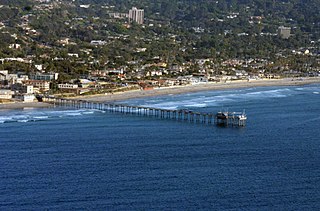
The Scripps Institution of Oceanography (SIO) is the center for oceanography and Earth science based at the University of California, San Diego. Its main campus is located in La Jolla, with additional facilities in Point Loma.

<span class="mw-page-title-main">Southern California Bight</span> Curved stretch of coastline in Southern California and northwestern Baja California

The Southern California Bight is a 692-kilometer-long stretch of curved coastline that runs along the west coast of the United States and Mexico, from Point Conception in California to Punta Colonet in Baja California, plus the area of the Pacific Ocean defined by that curve. This includes the Channel Islands of California and the Coronado Islands and Islas de Todo Santos of Baja California.

<span class="mw-page-title-main">Point Lobos</span> Cape in California, USA

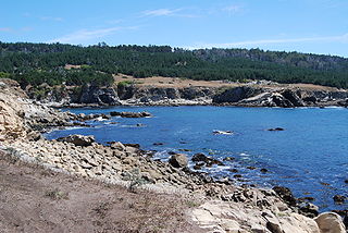
Point Lobos and the Point Lobos State Natural Reserve is a state park in California. Adjoining Point Lobos is "one of the richest marine habitats in California." The ocean habitat is protected by two marine protected areas, the Point Lobos State Marine Reserve and Point Lobos State Marine Conservation Area. The sea near Point Lobos is considered one of the best locations for scuba diving on the Monterey Peninsula and along the California coast.

<span class="mw-page-title-main">Birch Aquarium</span> Aquarium in San Diego, California

Birch Aquarium is an aquarium and the public outreach center for Scripps Institution of Oceanography at the University of California, San Diego. Accredited by the Association of Zoos and Aquariums, Birch Aquarium has an annual attendance of more than 439,000, including more than 40,000 school children, and features more than 3,000 animals representing 380 species. The hilltop site provides views of the Scripps Institution of Oceanography campus and the North Pacific Ocean. The mission of the aquarium reads: "As the public outreach center for Scripps Institution of Oceanography at UC San Diego, Birch Aquarium features the groundbreaking work of Scripps Oceanography and UC San Diego scientists through innovative exhibits and events. More than just an aquarium, Birch Aquarium offers hands-on learning opportunities and climate-based programming to 40,000-plus K-12 students each year on site, in schools and in the field.".

<span class="mw-page-title-main">La Jolla Cove</span> Inlet on the coast of California, United States

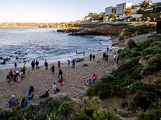
La Jolla Cove is a small cove with a beach that is surrounded by cliffs in La Jolla, San Diego, California. Point La Jolla forms the south side of the cove. The area is protected as part of a marine reserve and is popular with snorkelers, swimmers and scuba divers.

<span class="mw-page-title-main">La Jolla Shores</span> Beach in La Jolla, San Diego, California

La Jolla Shores, with its northern part Scripps Beach, is a beach and vacation/residential community of the same name in the community of La Jolla in San Diego, California. The La Jolla Shores business district is a mixed-use village encircling Laureate Park on Avenida de la Playa in the village of La Jolla Shores.

<span class="mw-page-title-main">Gerstle Cove State Marine Reserve</span> Marine reserve in California

Gerstle Cove State Marine Reserve (SMR) is a marine protected area that lies onshore from Salt Point State Park, within the Salt Point State Marine Conservation Area, in Sonoma County on California’s north central coast. The marine protected area covers 0.1 square miles. Gerstle Cove SMR prohibits the take of all living resources.

<span class="mw-page-title-main">Wheeler J. North</span>

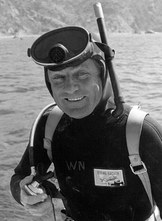
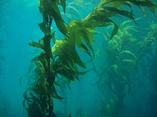
Wheeler James North, born in San Francisco, California, was a marine biologist and environmental scientist at the Scripps Institution of Oceanography and the California Institute of Technology. He is best known for his pioneering work to understand the ecology of California’s coastal kelp forests, and pioneering work in biomass fuels and the sequestration of atmospheric carbon dioxide.

<span class="mw-page-title-main">Carmel Pinnacles State Marine Reserve</span> Marine protected area in Carmel Bay

Carmel Pinnacles State Marine Reserve (SMR) is a marine protected area in Carmel Bay including a unique underwater pinnacle formation with adjacent kelp forest, submarine canyon head, and surfgrass. Carmel Bay is adjacent to the city of Carmel-by-the-Sea and is near Monterey, on California's central coast.

<span class="mw-page-title-main">Lovers Point State Marine Reserve</span> Marine protected area

Lovers Point State Marine Reserve (SMR) is one of four small marine protected areas located near the cities of Monterey and Pacific Grove, at the southern end of Monterey Bay on California’s central coast. The four MPAs together encompass 2.96 square miles (7.7 km2). The SMR protects all marine life within its boundaries. Fishing and take of all living marine resources is prohibited.

<span class="mw-page-title-main">Abalone Cove State Marine Conservation Area and Point Vicente State Marine Reserve</span> Palos Verdes Peninsula natural landmark

Abalone Cove State Marine Conservation Area (SMCA) and Point Vicente State Marine Reserve (SMR) are two adjoining marine protected areas that extend offshore in Los Angeles County on California's south coast. The two marine protected areas cover 19.87 sq mi (51.5 km2). The marine protected areas protect natural habitats and marine life by protecting or limiting removal of wildlife from within their boundaries. Point Vicente SMR, prohibits all take of living marine resources. Abalone Cove SMCA, prohibits take of all living marine resources, except recreational take of pelagic finfish, including Pacific bonito and white seabass by spearfishing, market squid by hand-held dip net, commercial take of coastal pelagic species and Pacific bonito by round haul net, and swordfish by harpoon.

<span class="mw-page-title-main">San Diego-Scripps Coastal Marine Conservation Area</span> Marine protected areas on Californias coast

San Diego-Scripps Coastal Marine Conservation Area (SMCA) and Matlahuayl State Marine Reserve (SMR) are adjoining marine protected areas that extend offshore from La Jolla in San Diego County on California's south coast. The two marine protected areas cover 2.51 square miles (6.5 km2). San Diego-Scripps Coastal SMCA prohibits the take of all living marine resources except that coastal pelagic species, not including market squid, may be taken recreationally by hook and line. Matlahuayl SMR prohibits the take of all living marine resources.

South La Jolla State Marine Conservation Area (SMCA) and South La Jolla State Marine Reserve (SMR) are two adjoining marine protected areas that extend offshore in San Diego County on California's south coast. The two marine protected areas cover 7.51 square miles (19.5 km2). The SMR protects marine life by prohibiting the removal of marine wildlife from within its borders, while the SMCA limits removal of marine wildlife.

<span class="mw-page-title-main">Laguna Beach State Marine Reserve</span> Marine protected area in California

Laguna Beach State Marine Reserve (SMR) and Laguna Beach State Marine Conservation Area (SMCA) are two adjoining marine protected areas that extend offshore of Laguna Beach in Orange County on California’s south coast. The SMR covers 6.27 square miles, and the SMCA covers an additional 3.44 square miles. These two MPAs are part of a four-MPA complex on the coast of southern Orange County. Each protects marine life by prohibiting or limiting the removal of marine wildlife from within its borders.

<span class="mw-page-title-main">Scripps Coastal Reserve</span> Protected area of San Diego County, California

Scripps Coastal Reserve is a 126-acre University of California Natural Reserve System reserve located west of UC San Diego in the La Jolla Farms area of La Jolla, California. Administered by UC San Diego, the site is owned by the University of California and managed for teaching and research.

<span class="mw-page-title-main">Anacapa State Marine Reserve</span> Marine reserve in the United States

The Anacapa State Marine Reserve (SMR) is a protected marine reserve located off the coast of Southern California, encompassing the area of water immediately north of Anacapa Island. Established to safeguard the marine ecosystems and biodiversity of the region, the reserve is one of the thirteen Marine Protected Areas (MPAs) of the larger Channel Islands National Park network.

<span class="mw-page-title-main">Ellen Browning Scripps Memorial Park</span> Park in San Diego, California

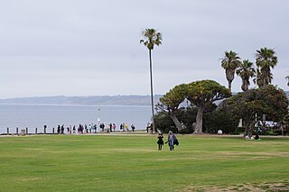
Ellen Browning Scripps Memorial Park, often referred to as Scripps Park, is an urban park located in La Jolla within the city of San Diego, California. The 5.6 acres (2.3 ha) park, part of the unceded ancient homeland and traditional territory of the Kumeyaay Nation, is sited on a sandstone bluff overlooking the Pacific Ocean. It is an open-space, landscaped environment heavily used by residents and visitors from all over the world.

<span class="mw-page-title-main">Red Rest and Red Roost Cottages</span> Historic beach cottages

The Red Roost and The Red Rest, built in 1894, are historic beach cottages overlooking La Jolla Cove in La Jolla, San Diego, California. At one time, they were outstanding examples of the first-generation California bungalow. Their placement on the National Register of Historic Places in 1976 has not prevented serious deterioration due to neglect.

References

  1. Bailey, Eric (November 27, 1988). "Sharing Deep Secrets: Underwater Park Lets Divers Enjoy Variety of Protected Marine Life". Los Angeles Times. Retrieved 21 May 2024.
  2. "Cultural History". About Matlahuayl State Marine Reserve, and San Diego-Scripps Coastal State Marine Conservation Area. California Department of Fish and Wildlife. Retrieved 21 May 2024.
  3. "San Diego La Jolla Underwater Park". Read the Plaque. Retrieved 22 May 2024.
  4. Schwab, Dave (May 22, 2024). "Bottom Scratchers Dive Club honored with plaque in La Jolla". sdnews.com. Retrieved 23 May 2024.
  5. Mackin-Solomon, Ashley (July 28, 2023). "Plaque honoring Bottom Scratchers is proposed for Point La Jolla". La Jolla Light. Retrieved 23 May 2024.
  6. "Underwater Park Ecology Reserve Dedication Slated". San Diego Union. No. August 20, 1971.
  7. 1 2 3 Garfield, Judith Lea (1994). The San Diego-La Jolla Underwater Park Ecological Reserve. San Diego: Picaro.
  8. "California Marine Waters Areas of Special Biological Significance: San Diego-La Jolla Ecological Reserve" (PDF). State Water Resources Control Board. Retrieved 22 May 2024.
  9. "About Matlahuayl State Marine Reserve, and San Diego-Scripps Coastal State Marine Conservation Area: Recreation". California Department of Fish and Wildlife.
  10. "Mammoth Caves La Jolla". Digital Archives: Collections. City of San Diego.
  11. Mackin-Solomon, Ashley (October 19, 2020). "Map of the Grand Canyons of La Jolla's marine mosaic opens to the public". La Jolla Light. Retrieved 22 May 2024.
  12. Elling, Regina. "Sculptor Dives into the Deep End for Bronze Map of La Jolla Canyons". La Jolla Light. No. February 8, 2023. Retrieved 23 May 2024.