
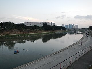
The Pasig River is a water body in the Philippines that connects Laguna de Bay to Manila Bay. Stretching for 25.2 kilometers (15.7 mi), it bisects the Philippine capital of Manila and its surrounding urban area into northern and southern halves. Its major tributaries are the Marikina River and San Juan River. The total drainage basin of the Pasig River, including the basin of Laguna de Bay, covers 4,678 square kilometers (1,806 sq mi).

Quezon City, also known as the City of Quezon and Q.C., is the most populous city in the Philippines. According to the 2020 census, it has a population of 2,960,048 people. It was founded on October 12, 1939, and was named after Manuel L. Quezon, the second president of the Philippines.

Mandaluyong, officially the City of Mandaluyong, is a first class highly urbanized city in the National Capital Region of the Philippines. According to the 2020 census, it has a population of 425,758 people.

Pasig, officially the City of Pasig, is a highly urbanized city in the National Capital Region of the Philippines. According to the 2020 census, it has a population of 803,159 people.

San Juan, officially the City of San Juan, is a 1st class highly urbanized city in the National Capital Region of the Philippines. According to the 2020 census, it has a population of 126,347 people. It is geographically located at Metro Manila's approximate center and is also the country's smallest city in terms of land area.

Santa Mesa is a district in Manila, Philippines. It is surrounded by the Pasig River on the southwestern side, and by the San Juan River on its southern and eastern side. Land borders include the districts of San Miguel to the west and Sampaloc to the north; and to the northeast is Quezon City.
The Marikina River is a river in eastern Metro Manila, Philippines. It is the largest tributary of the Pasig River, with headwaters located in the Sierra Madre Mountains in Rodriguez, Rizal province.
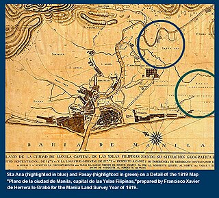
Namayan, also called Sapa, Maysapan, and sometimes Lamayan, was an independent indigenous polity on the banks of the Pasig River in the Philippines. It is believed to have achieved its peak in 1175, and to have gone into decline sometime in the 13th century, although it continued to be inhabited until the arrival of European colonizers in the 1570s.

Greenhills is an administrative division in eastern Metro Manila, the Philippines. It is an urban barangay in San Juan and is the largest barangay in the city, covering a total area of 2.09 square kilometers (209 ha) that spans over a third of San Juan's total land area.

Ortigas Avenue is a 12.1 km (7.5 mi) highway running from eastern Metro Manila to western Rizal in the Philippines. It is one of the busiest highways in Metro Manila, serving as the main thoroughfare of the metro's east–west corridor, catering mainly to the traffic to and from Rizal.

Aurora Boulevard is a four-to-ten lane major thoroughfare in Quezon City and San Juan in Metro Manila, Philippines. It was named after Doña Aurora Quezon, the consort of Commonwealth President Manuel Luis Quezon. It is one of the major roads in the commercial district of Araneta City in Cubao. Line 2 follows the alignment of the boulevard.
Shaw Boulevard is a 4-8 lane highway connecting the cities of Mandaluyong and Pasig in the Philippines. The boulevard is named after William James Shaw, the founder of the Wack Wack Golf and Country Club in Mandaluyong. The road is one of the major thoroughfares of the Ortigas Center in Mandaluyong and Pasig, housing many shopping malls like the Starmall shopping center and the posh Shangri-La Plaza at the EDSA-Shaw intersection and The Marketplace, which is visible from the Kalentong-Shaw intersection and Sevilla Bridge.

Gregorio Araneta Avenue is a suburban arterial road in the Santa Mesa Heights area of Quezon City, northeastern Metro Manila, Philippines. Built in 1985, it is a 6- to 8-lane divided avenue designated as part of Circumferential Road 3 (C-3) and a physical continuation of Sergeant Rivera Street which travels from Santo Domingo Avenue at its north end near Balintawak in Quezon City, and meets N. Domingo Street in the south in San Juan near the border with Santa Mesa, Manila. En route, it intersects with Del Monte Avenue, Quezon Avenue, Eulogio Rodriguez Sr. Avenue and Magsaysay-Aurora Boulevard passing through barangays Balingasa, Manresa, Masambong, Sienna, Santo Domingo, Talayan, Tatalon, Santol, and Doña Imelda in Quezon City and Progreso in San Juan.
The Metro Rail Transit Line 4 (MRT-4) is an upcoming rapid transit line serving the Greater Manila Area of the Philippines. The 12.7 km (7.9 mi), 10-station elevated railway will connect Ortigas Center in Metro Manila and the suburban municipality of Taytay, Rizal. It will traverse along Ortigas Avenue and Manila East Road, starting at the former's junction with EDSA in Quezon City to the west until it terminates near the New Taytay Public Market to the east.

Radial Road 5, more commonly referred to as R-5, is a network of roads and bridges that all together form the fifth radial road of Manila in the Philippines. The road links the City of Manila with Mandaluyong and Pasig in the east, leading out of Metro Manila into the province of Rizal and south towards Laguna. It is the only arterial road traversing the east side of Laguna de Bay.

The following is an alphabetical list of articles related to the Philippine capital region of Metro Manila.

San Francisco del Monte, also referred to as SFDM, is a district of Quezon City, Metro Manila, the Philippines. It is bisected by two major thoroughfares, Fernando Poe Jr. Avenue and the eponymous Del Monte Avenue, and is bounded by Atty. Pat Senador Sr. Street and Baler Street to the north, and Judge Juan Luna Street, Paraiso Street, and Cooper Street to the east.

Mariana, is an administrative division in eastern Metro Manila, the Philippines. It is an urban barangay in Quezon City in a middle class residential and commercial area known as New Manila, which includes Barangay Mariana and the adjacent Barangay Damayang Lagi.


