San Pedro Mixtepec, Juquila

Last updated
San Pedro Mixtepec
Municipality and town
Mexico Oaxaca San Pedro Mixtepec distrito 22 location map.svg
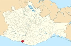
Location of the municipality in Oaxaca
Mexico States blank map.svg
Red pog.svg
San Pedro Mixtepec
Location in Mexico
Coordinates: 16°0′0″N97°7′1″W / 16.00000°N 97.11694°W / 16.00000; -97.11694
CountryFlag of Mexico.svg  Mexico
State Oaxaca
Area
  Total325.1 km2 (125.5 sq mi)
  Town2.34 km2 (0.90 sq mi)
Elevation
220 m (720 ft)
Population
 (2020 census) [1]
  Total49,780
  Density150/km2 (400/sq mi)
  Town
5,103
  Town density2,200/km2 (5,600/sq mi)
Time zone UTC-6 (Central Standard Time)
  Summer (DST) UTC-5 (Central Daylight Time)

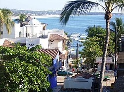
San Pedro Mixtepec is a town and municipality in Oaxaca in south-western Mexico. It is part of the Juquila District in the center of the Costa Region. [2]

Contents

A view of the town of Puerto Escondido Mexico 167.jpg
A view of the town of Puerto Escondido

Geography

The municipality covers an area of 325.1 km2 at an average altitude of 220 meters above sea level on the Pacific coast of Oaxaca. The climate is warm and humid. Flora is diverse, including tulips, roses, bougainvillea, cempaxóchitl, rose garden, lemon blossoms, noon platanillo, prickly pear, cedar, macuil, huanacaxtle, mahogany and palm Fruit trees include mango, banana, mamey sapote, sapodilla, coconut, lemon, rtamarindo, almond, orange and lemon lime. [2]

Population

As of 2005, the municipality had 7,881 households with a total population of 33,682 of whom 919 spoke an indigenous language. 40% of the population of the municipality is engaged in agriculture, and 20% in animal husbandry. Tourism employs 20% of the population in the port and tourist center of Puerto Escondido and the nearby Bajos de Chila. [2]

Related Research Articles

San Juan, Spanish for Saint John, most commonly refers to:

<span class="mw-page-title-main">Puerto Escondido, Oaxaca</span> City in Oaxaca, Mexico

Puerto Escondido is a small port and tourist center in the municipality of San Pedro Mixtepec Distrito 22 in the Mexican state of Oaxaca. Prior to the 1930s, there was no town. The bay had been used as a port intermittently to ship coffee, but there was no permanent settlement due to the lack of potable water. The name "Puerto Escondido" had roots in the legend of a woman who escaped her captors and hid here. The Nahuatl word for this area was Zicatela, meaning “place of large thorns". Today, it refers to the area's most famous beach.

<span class="mw-page-title-main">Tlaxiaco</span> City in Oaxaca, Mexico

Tlaxiaco is a city, and its surrounding municipality of the same name, in the Mexican state of Oaxaca. It is located in the Tlaxiaco District in the south of the Mixteca Region, with a population of about 17,450.

Santa Catarina Juquila is a town in the State of Oaxaca, Mexico, and is the seat of the municipality also called Santa Catarina Juquila. It is part of the Juquila District in the center of the Costa Region. The name "Juquila" comes from "Xuhquililla", which means "Place of blue milkweed".

San Gabriel Mixtepec is a town and municipality in Oaxaca in south-western Mexico. It is part of the Juquila District in the center of the Costa Region. The name "Mixtepec" means "Hill of clouds".

<span class="mw-page-title-main">San Juan Juquila Mixes</span> Municipality and town in Oaxaca, Mexico

San Juan Juquila Mixes is a town and municipality in Oaxaca in south-western Mexico. It is part of the Yautepec District in the east of the Sierra Sur Region. The name "Juquila" means "beautiful vegetables".

San Juan Juquila Vijanos is a town and municipality in Oaxaca in south-western Mexico. The municipality covers an area of 37 km². It is part of the Villa Alta District in the center of the Sierra Norte Region.

San Juan Lachao is a town and municipality in Oaxaca in south-western Mexico. It is part of the Juquila District in the center of the Costa Region.

<span class="mw-page-title-main">San Juan Mixtepec, Mixteca</span> Municipality and town in Oaxaca, Mexico

San Juan Mixtepec is a town and municipality in Oaxaca in south-western Mexico. The municipality covers an area of 209.24 km², and is part of the Juxtlahuaca District of the Mixteca Region.

San Juan Mixtepec is a town and municipality in Oaxaca in south-western Mexico. The municipality covers an area of 53.59 km². It is part of the Miahuatlán District in the south of the Sierra Sur Region.

San Juan Quiahije is a town and municipality in Oaxaca in south-western Mexico. It is part of the Juquila District in the centre of the Costa Region. The origin of the name Quiahije is not known, some people conjecture it might mean "Stone Forest" in the Zapotec language.

San Miguel Mixtepec is a town and municipality in Oaxaca in south-western Mexico. The municipality covers an area of 48.48 km². It is part of the Zimatlán District in the west of the Valles Centrales Region

<span class="mw-page-title-main">Villa de Tututepec de Melchor Ocampo</span> Municipality and town in Oaxaca, Mexico

Villa de Tututepec de Melchor Ocampo is a town and municipality in Oaxaca in south-western Mexico.

<span class="mw-page-title-main">San Pedro Juchatengo</span> Municipality and town in Oaxaca, Mexico

San Pedro Juchatengo is a town and municipality in Oaxaca in south-western Mexico. It is part of the Juquila District in the centre of the Costa Region. The name comes from "Xochiatengo", which means "Flowers on the waters edge".

Tataltepec de Valdés is a town and municipality in Oaxaca in south-western Mexico. It is part of the Juquila District in the center of the Costa Region. The town was established around 400-300 BC. The name "Tataltepec" means "Grandfather hill". Antonio Valdés, born in the town, was an early leader of the independence movement in Oaxaca who died on 19 November 1811.

<span class="mw-page-title-main">Costa Region</span> Region in Oaxaca, Mexico

The Costa Region or Costa Chica lies on the Pacific coast of the state of Oaxaca, Mexico, south of the more mountainous Sierra Sur inland from the coast. It includes the districts of Jamiltepec, Juquila and Pochutla.

<span class="mw-page-title-main">Zimatlán District</span> District in Oaxaca, Mexico

Zimatlán District is located in the west of the Valles Centrales Region of the State of Oaxaca, Mexico.

<span class="mw-page-title-main">Miahuatlán District</span> District in Oaxaca, Mexico

Miahuatlán District is located in the south of the Sierra Sur Region of the State of Oaxaca, Mexico.

<span class="mw-page-title-main">Juquila District</span> District in Oaxaca, Mexico

Juquila District is located in the center of the Costa Region of the State of Oaxaca, Mexico, on the Pacific coast. It has an area of 5,055 km2. As of 2005 it had a total population of 134,365 of whom 33,106 spoke an indigenous language. Economic activities include agriculture and tourism. The Santuario (Sanctuary) de Juquila is a major attraction.

San Pedro Mixtepec may refer to

References

  1. Citypopulation.de Population of San Pedro Mixtepec - Dto. 22 (Juquila) municipality with localities
  2. 1 2 3 "SAN PEDRO MIXTEPEC - DISTR. 22". Enciclopedia de los Municipios de México. Instituto Nacional para el Federalismo y el Desarrollo Municipal . Retrieved June 12, 2009.