San Pedro de Quemes Municipality

Last updated
San Pedro de Quemes
Municipality

Salar de Chiguana - Potosi - Bolivia.jpg

Salar de Chiguana
50902 San Pedro de Quemes Municipio.png
Location within Potosí Department
Bolivia adm location map.svg
Red pog.svg
San Pedro de Quemes
Location within Bolivia
Coordinates: 21°3′S68°18′W / 21.050°S 68.300°W / -21.050; -68.300 Coordinates: 21°3′S68°18′W / 21.050°S 68.300°W / -21.050; -68.300
CountryFlag of Bolivia.svg  Bolivia
Department Potosí Department
Province Nor Lípez Province
Seat San Pedro de Quemes
Area
  Total 1,657 sq mi (4,291 km2)
Elevation 13,000 ft (4,000 m)
Population (2001)
  Total 815
  Ethnicities Quechua
Time zone -4 (UTC-4)

San Pedro de Quemes (Quechua : Qimis) is the second municipal section of the Nor Lípez Province in the Potosí Department in Bolivia. Its seat is San Pedro de Quemes.

Municipalities of Bolivia administrative division of Bolivia

Municipalities in Bolivia are administrative divisions of the entire national territory governed by local elections. Municipalities are the third level of administrative divisions, below departments and provinces. Some of the provinces consist of only one municipality. In these cases the municipalities are identical to the provinces they belong to.

Nor Lípez Province Province in Potosí Department, Bolivia

Nor Lípez is a province in the Bolivian department of Potosí. Its seat is Colcha "K", also called Villa Martín. The majority of the area of the province was titled as the Nor Lípez Native Community Land on 19 April 2011. One of the largest mines of Bolivia, the San Cristóbal Mine, is located near San Cristóbal in Colcha "K" municipality.

Potosí Department Place in Potosí, Bolivia

Potosí is a department in southwestern Bolivia. It comprises 118,218 km² with 823,517 inhabitants. The capital is the city of Potosí. It is mostly a barren, mountainous region with one large plateau to the west, where the largest salt flat in the world, Salar de Uyuni, is located.

Contents

Geography

The municipality lies at the Uyuni salt flat.

Some of the highest mountains of the municipality are listed below: [1] [2] [3] [4] [5]

Chiwana mountain in Bolivia

Chiwana is a 5,301-metre-high (17,392 ft) mountain in Bolivia. It is located in the Potosí Department, on the border of the Nor Lípez Province, Colcha "K" Municipality, and the Quemes Municipality. The mountain lies at the Chiwana salt flat.

Chaska Urqu (Nor Lípez)

Ch'aska Urqu is a mountain in the Andes of Bolivia, about 4,100 metres (13,451 ft) high. It is located in the Potosí Department, Nor Lípez Province, Quemes Municipality, Pelcoya Canton. Ch'aska Urqu lies near the border with Chile, southeast of the Ollagüe (Ullawi) volcano and southwest of Wanaku.

Kachi Unu mountain in the Andes of Bolivia

Kachi Unu is a 4,641-metre-high (15,226 ft) mountain in the Andes of Bolivia. It is situated in the Potosí Department, Nor Lípez Province, Colcha "K" Municipality, San Juan Canton, and in the Quemes Municipality, Chiguana Canton. Kachi Unu lies northwest of Chiwana and Chakra Urqu and northeast of Tomasamil and Millu Urqu.

Many of the mountains and volcanoes are a natural border to Chile.

Subdivision

The municipality consists of the following cantons: [6]

Pelcoya Canton Canton in Potosí Department, Bolivia

Pelcoya is one of the cantons of the San Pedro de Quemes Municipality, the second municipal section of the Nor Lípez Province in the Potosí Department of Bolivia. During the census of 2001 it had 135 inhabitants. Its seat is Pelcoya with a population of 79 in 2001.

San Pedro de Quemes Canton Canton in Potosí Department, Bolivia

San Pedro de Quemes is one of the cantons of the San Pedro de Quemes Municipality, the second municipal section of the Nor Lípez Province in the Potosí Department of Bolivia. During the census of 2001 it had 574 inhabitants. Its seat is San Pedro de Quemes with a population of 490 in 2001.

The people

The people are mainly not indigenous and 45,0% are citizens of Quechua descent. [7]

Indigenous peoples of the Americas Pre-Columbian inhabitants of North, Central, and South America and their descendants

The indigenous peoples of the Americas are the Pre-Columbian peoples of North, Central and South America and their descendants.

Quechua people ethnic group

Quechua people or Quecha peoples may refer to any or all speakers of the Quechua languages, which originated among the indigenous peoples of South America. Most Quechua speakers live in Peru, although there is a significant population living in Ecuador, Bolivia, Chile, Colombia and Argentina.

Ethnic group%
Quechua 45.0
Aymara 6.3
Guaraní, Chiquitos, Moxos 0.2
Not indigenous 48.3
Other indigenous groups0.2

See also

Related Research Articles

Tomás Frías Province Province in Potosí Department, Bolivia

Tomás Frías is a province in the northern parts of the Bolivian Potosí Department. Its capital is Potosí which is also the capital of the department. The province is named after the former president Tomás Frías Ametller.

José María Linares Province Province in Potosí Department, Bolivia

José María Linares is a province in the eastern parts of the Bolivian department of Potosí. Its capital is Puna.

Nor Chichas Province Province in Potosí Department, Bolivia

Nor Chichas is a province in the Eastern parts of the Bolivian Potosí Department. Its seat is Cotagaita.

Sur Lípez Province Province in Potosí Department, Bolivia

Sur Lípez or Sud Lípez is a province in the Potosí Department in Bolivia. The seat of the province is San Pablo de Lípez.

Chayanta Province Province in Potosí Department, Bolivia

Chayanta is a province in the northern parts of the Bolivian Potosí Department. Its capital is Colquechaca.

Potosí Municipality Municipality in Potosí Department, Bolivia

Potosí Municipality is the capital municipality of the Tomás Frías Province in the Potosí Department in Bolivia. Its seat is Potosí which is the capital of the department as well.

San Pablo de Lípez Municipality Municipality in Potosí Department, Bolivia

San Pablo de Lípez Municipality is the first municipal section of the Sur Lípez Province in the Potosí Department in Bolivia. Its seat is San Pablo de Lípez.

Ravelo Municipality Municipality in Potosí Department, Bolivia

Ravelo Municipality is the second municipal section of the Chayanta Province in the Potosí Department in Bolivia. Its seat is Ravelo.

Colcha "K" Municipality Municipality in Potosí Department, Bolivia

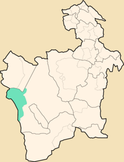
Colcha "K" Municipality is the first municipal section of the Nor Lípez Province in the Potosí Department in Bolivia. Its seat is Colcha "K" or Villa Martín.

Wanaku (Potosí) mountain in Bolivia

Wanaku is a mountain in the Andes of Bolivia, about 4,700 metres (15,420 ft) high. It is situated in the Potosí Department, Nor Lípez Province, Quemes Municipality, Pelcoya Canton. Wanaku lies southeast of the Ollagüe (Ullawi) volcano and northeast of Ch'aska Urqu.

Qaral

Qaral is a 4,988-metre-high (16,365 ft) mountain in the Bolivian Andes. It is situated in the Potosí Department, Nor Lípez Province, Colcha "K" Municipality. Qaral lies south of the Uyuni salt flat, south-west of the mountain Lliphi. Some of the nearest villages are Santiago and San Juan. An intermittent stream named Urqu Sunqu originates at the mountain. It flows to the south-west.

Millu Urqu

Millu Urqu Quechua millu salty, urqu mountain, "salty mountain", also spelled Millu Orkho) is a 4,701-metre-high (15,423 ft) mountain in the Andes of Bolivia. It is situated in the Potosí Department, Nor Lípez Province, Quemes Municipality. Millu Urqu lies southwest of Chakra Urqu and Kachi Unu and northwest of Chiwana.

Chakra Urqu

Chakra Urqu Quechua chakra field, urqu mountain, "field mountain", also spelled Chajra Orkho) or Ch'aqra Urqu is a 4,347-metre-high (14,262 ft) mountain in the Andes of Bolivia. It is situated in the Potosí Department, Nor Lípez Province, Colcha "K" Municipality. Chakra Urqu lies northeast of the mountains Chiwana and Millu Urqu and southeast of Kachi Unu.

Luxsar mountain in Bolivia

Luxsar or Luxar is a 5,504-metre-high (18,058 ft) mountain in Bolivia. It is located in the Potosí Department, Nor Lípez Province, Quemes Municipality. It lies north of the Chiwana salt flat.

Puka Urqu (Charcas)

Puka Urqu is a 2,811-metre-high (9,222 ft) mountain in the Bolivian Andes. It is located in the Potosí Department, Charcas Province, San Pedro de Buena Vista Municipality. The Ch'alla Mayu flows along its southern slope.

Paka Chuku

Paka Chuku is a mountain in the Bolivian Andes which reaches a height of approximately 2,600 m (8,500 ft). It is located in the Potosí Department, Charcas Province, San Pedro de Buena Vista Municipality. Puka Chuku lies southeast of Puka Urqu. The Ch'alla Mayu flows along its northern slope.

References

  1. "San Pedro de Quemes" . Retrieved October 16, 2015.
  2. Bolivian IGM map 1:50,000 Chiguana 6030-IV
  3. Bolivian IGM map 1:50,000 Estancia Chilala 6031-IV
  4. Bolivian IGM map 1:50,000 Villa Martín 6031-I
  5. "South America Maps". Joint Operations Graphic. Retrieved October 16, 2015.
  6. National Institute of Statistics of Bolivia
  7. obd.descentralizacion.gov.bo/municipal/fichas/ (inactive)