Uyuni

Last updated
Uyuni
City
Uyuni Potosi Ave Aerial.jpg
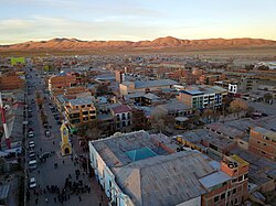
Plaza Arce adjoins Potosí Avenue to mark the center of town.
Bandera de Uyuni.jpg
Bolivia adm location map.svg
Red pog.svg
Uyuni
Location in Bolivia
Coordinates: 20°27′46″S66°49′26″W / 20.46278°S 66.82389°W / -20.46278; -66.82389
Country Bolivia
Department Potosí Department
Province Antonio Quijarro Province
Municipality Uyuni Municipality
Canton Uyuni Canton
Population
 (2012)
  Total29,672 [1]
  Ethnicities
Quechua Aymara
Time zone UTC-4 (BOT)

Uyuni (Aymara, uyu pen (enclosure), yard, cemetery, [2] -ni a suffix to indicate ownership, "the one that has got a pen", "the one with a pen") is a city in the southwest of Bolivia.

Contents

Uyuni primarily serves as a gateway for tourists visiting the world's largest salt flats, the nearby Uyuni salt flat. Each year the city receives approximately 60,000[ citation needed ] visitors from around the globe. The city also acts as a gateway for commerce and traffic crossing into and out of Bolivia from and to Chile, and there is a customs and immigration post downtown. Agriculture in the area is generally limited to quinoa, llamas, and sheep. [3] [4]

Founded in 1890 as a trading post, the city has a population of 29,672 (2012 official census). [1] The town has an extensive street-market. It lies at the edge of an extensive plain at an elevation of 3,700 m (12,139 ft) above sea level, with more mountainous country to the east.

Transport

It is an important transport hub, being the location of a major railway junction. Four lines join here, respectively from La Paz (via Oruro), Calama (in Chile), Potosí, and Villazón (on the Argentine border, where the line now ends).

Uyuni is connected by road to Oruro - La Paz, Sucre, Villazón (border with Argentina) and Ollagüe, Chile.

The city is also served by the Joya Andina Airport. Currently, two local airlines are flying regularly to the city from La Paz, Sucre and Rurrenabaque: Amazonas and Transporte Aéreo Militar.

Tourist attractions

Train cemetery

One of the major tourist attractions of the area is an antique train cemetery. It is located 3 km outside Uyuni and is connected to it by the old train tracks. The town served in the past as a distribution hub for the trains carrying minerals on their way to the Pacific Ocean ports. The train lines were built by British engineers who arrived near the end of the 19th century and formed a sizable community in Uyuni. The engineers were invited by British-sponsored Antofagasta and Bolivia Railway Companies, which is now Ferrocarril de Antofagasta a Bolivia. The rail construction started in 1888 and ended in 1892. It was encouraged by the then Bolivian President Aniceto Arce, who believed Bolivia would flourish with a good transport system, but it was also constantly sabotaged by the local indigenous people who saw it as an intrusion into their lives. The trains were mostly used by the mining companies. In the 1940s, the mining industry collapsed, partly due to the mineral depletion. Many trains were abandoned thereby producing the train cemetery. There are talks to build a museum out of the cemetery. [5]

Uyuni Decembre 2007 - Cimetiere de Trains 1.jpg
Train cemetery

Images

Climate

According to the Köppen climate classification, Uyuni has an alpine cold desert climate (Köppen climate classification BWk) with mild summers and cool winters. Night time temperatures stay chilly year round.

Climate data for Uyuni, elevation: 3,680 metres (12,070 ft), 1981–2010 normals, extremes 1945–present
MonthJanFebMarAprMayJunJulAugSepOctNovDecYear
Record high °C (°F)30.0
(86.0)
30.0
(86.0)
31.5
(88.7)
26.4
(79.5)
24.0
(75.2)
19.5
(67.1)
20.5
(68.9)
29.0
(84.2)
26.1
(79.0)
26.8
(80.2)
28.2
(82.8)
29.1
(84.4)
31.5
(88.7)
Mean daily maximum °C (°F)20.6
(69.1)
20.3
(68.5)
20.2
(68.4)
18.6
(65.5)
15.2
(59.4)
12.8
(55.0)
13.1
(55.6)
14.9
(58.8)
16.5
(61.7)
19.0
(66.2)
20.6
(69.1)
20.6
(69.1)
17.6
(63.7)
Daily mean °C (°F)13.0
(55.4)
12.4
(54.3)
11.7
(53.1)
8.7
(47.7)
4.4
(39.9)
1.6
(34.9)
1.7
(35.1)
3.6
(38.5)
5.6
(42.1)
8.2
(46.8)
10.3
(50.5)
11.6
(52.9)
7.7
(45.9)
Mean daily minimum °C (°F)5.5
(41.9)
4.6
(40.3)
3.3
(37.9)
−1.3
(29.7)
−6.3
(20.7)
−9.6
(14.7)
−9.7
(14.5)
−7.6
(18.3)
−5.4
(22.3)
−2.6
(27.3)
0.1
(32.2)
2.7
(36.9)
−2.1
(28.2)
Record low °C (°F)−7.4
(18.7)
−6.0
(21.2)
−10.0
(14.0)
−14.0
(6.8)
−22.0
(−7.6)
−22.0
(−7.6)
−24.0
(−11.2)
−25.7
(−14.3)
−21.5
(−6.7)
−19.2
(−2.6)
−15.2
(4.6)
−8.8
(16.2)
−25.7
(−14.3)
Average precipitation mm (inches)79.3
(3.12)
37.7
(1.48)
28.5
(1.12)
2.3
(0.09)
0.8
(0.03)
1.8
(0.07)
0.0
(0.0)
1.7
(0.07)
1.8
(0.07)
2.8
(0.11)
3.8
(0.15)
26.4
(1.04)
190.9
(7.52)
Average precipitation days11.17.35.81.00.30.90.00.30.40.30.93.832.8
Average snowy days0.00.240.00.00.040.030.00.100.00.00.00.00.48
Source: Servicio Nacional de Meteorología e Hidrología de Bolivia [6]

Related Research Articles

<span class="mw-page-title-main">Demographics of Bolivia</span>

The demographic characteristics of the population of Bolivia are known from censuses, with the first census undertaken in 1826 and the most recent in 2012. The National Institute of Statistics of Bolivia (INE) has performed this task since 1950. The population of Bolivia in 2012 reached 10 million for the first time in history. The population density is 9.13 inhabitants per square kilometer, and the overall life expectancy in Bolivia at birth is 68.2 years. The population has steadily risen from the late 1800s to the present time. The natural growth rate of the population is positive, which has been a continuing trend since the 1950s; in 2012, Bolivia's birth rate continued to be higher than the death rate. Bolivia is in the third stage of demographic transition. In terms of age structure, the population is dominated by the 15–64 segment. The median age of the population is 23.1, and the gender ratio of the total population is 0.99 males per female.

Transport in Bolivia is mostly by road. The railways were historically important in Bolivia, but now play a relatively small part in the country's transport system. Because of the country's geography, aviation is also important.

<span class="mw-page-title-main">Salar de Uyuni</span> Salt flat in Bolivia

Salar de Uyuni is the world's largest salt flat, or playa, at over 10,000 square kilometres (3,900 sq mi) in area. It is in the Daniel Campos Province in Potosí in southwest Bolivia, near the crest of the Andes at an elevation of 3,656 m (11,995 ft) above sea level.

<span class="mw-page-title-main">Oruro</span> City in Oruro Department, Bolivia

Oruro or Uru Uru is a city in Bolivia with a population of 264,683, about halfway between La Paz and Sucre in the Altiplano, approximately 3,709 meters (12,169 ft) above sea level.

<span class="mw-page-title-main">Aymara people</span> Indigenous people in the Andes and Altiplano regions of South America

The Aymara or Aimara, people are an indigenous people in the Andes and Altiplano regions of South America; about 2.3 million live in northwest Argentina, Bolivia, Chile, and Peru. Their ancestors lived in the region for many centuries before becoming a subject people of the Inca in the late 15th or early 16th century, and later of the Spanish in the 16th century. With the Spanish-American wars of independence (1810–1825), the Aymaras became subjects of the new nations of Bolivia and Peru. After the War of the Pacific (1879–1883), Chile annexed territory with the Aymara population.

<span class="mw-page-title-main">Ismael Montes</span> 26th and 28th President of Bolivia

Ismael Montes Gamboa was a Bolivian general and political figure who served as the 26th president of Bolivia twice nonconsecutively from 1904 to 1909 and from 1913 to 1917. During his first term, the Treaty of Peace and Friendship with Chile was signed on 20 October 1904.

<span class="mw-page-title-main">Empresa de los Ferrocarriles del Estado</span>

Empresa de los Ferrocarriles del Estado is the national railway and the oldest state-run enterprise in Chile. It manages the infrastructure and operating rail services in the country.

<span class="mw-page-title-main">Mariano Baptista</span> 23rd President of Bolivia

Mariano Baptista Caserta was a Bolivian politician, orator and journalist. An outstanding intellectual of his time, he was a deputy in various periods, Minister of Foreign Affairs (1873-1876) and (1888-1891), President of Congress (1884-1888), Constitutional President of the Republic (1892-1896) and Vice President of the Republic (1884-1888).

<span class="mw-page-title-main">Hilarión Daza</span> President of Bolivia (1840–1894)

Hilarión Daza was a Bolivian military officer who served as the 19th president of Bolivia from 1876 to 1879. During his presidency, the infamous War of the Pacific started, a conflict which proved to be devastating for Bolivia.

<span class="mw-page-title-main">Ferrocarril de Antofagasta a Bolivia</span> Narrow gauge railway line in Chile

The Ferrocarril de Antofagasta a Bolivia is a private railway operating in the northern provinces of Chile. It is notable in that it was one of the earliest railways built to 2 ft 6 in narrow gauge, with a route that climbed from sea level to over 4,500 m (14,764 ft), while handling goods traffic totaling near 2 million tons per annum. It proved that a railway with such a narrow gauge could do the work of a standard gauge railway, and influenced the construction of other railways such as the Estrada de Ferro Oeste de Minas. It was later converted to 1,000 mmmetre gauge, and still operates today.

<span class="mw-page-title-main">Severo Fernández</span> 24th President of Bolivia

Severo Fernández Alonso Caballero was a Bolivian lawyer and politician who served as the 24th president of Bolivia from 1896 to 1899 and as the tenth vice president of Bolivia from 1892 to 1896. He is best remembered as the last president of the 15-year period of Conservative Party hegemony (1884–99).

Following is a list of railway stations in Bolivia, categorized by eastern and western networks. The eastern and western networks do not directly connect, except via a roundabout route through Argentina.

<span class="mw-page-title-main">Rail transport in Bolivia</span>

The Bolivian rail network has had a peculiar development throughout its history.

<span class="mw-page-title-main">Totora, Cochabamba</span> Town in Cochabama, Bolivia

Totora, Tutura or T'utura is a town in the Carrasco Province of the Cochabamba Department in Bolivia. It is the capital and most-populous place of the Totora Municipality. As of the 2012 census, the population is 1,925. The first settlers were Inca Indians. Totora was officially settled in 1876, and declared a town by the Government of Bolivia in 1894.

<span class="mw-page-title-main">Bolivians</span> People identified with the country of Bolivia

Bolivians are people identified with the country of Bolivia. This connection may be residential, legal, historical or cultural. For most Bolivians, several of these connections exist and are collectively the source of their being Bolivian.

Uyuni is a mountain in the Andes of Bolivia, about 5,084 metres (16,680 ft) high. It is situated in the Potosí Department, Antonio Quijarro Province, Tomave Municipality, Tomave Canton, east of the Uyuni salt flat and south-west of the Nuevo Mundo volcano and Kuntur Chukuña.

<span class="mw-page-title-main">Pedro José de Guerra</span>

Pedro José Domingo de Guerra was a Bolivian jurist who served as the acting President of Bolivia in 1879 in the absence of Hilarión Daza who was personally commanding the Bolivian Army in the War of the Pacific between Chile, and an allied Bolivia and Peru. His grandson, José Gutiérrez Guerra, was also president of Bolivia between 1917 and 1920.

<span class="mw-page-title-main">Bolivian Civil War</span> Armed conflict in Bolivia

The Bolivian Civil War, also known as the Federal War was a civil war in Bolivia fought from 1898 to 1899. The war saw two factions, a conservative side supported by the political, economic and religious elite of the country with control of the armed forces and who defended a unitary state, and a liberal faction opposed to the policies set by the state and that intended to transform the country into a federation, with support of the peasantry, the indigenous peoples and small Catholic businesses.

<span class="mw-page-title-main">History of rail transport in Bolivia</span>

The history of rail transport in Bolivia began in the 1870s after almost three decades of failed efforts to build railroads to integrate the country, mining was the driving force for the construction of railways. The need to transport saltpeter to the coast triggered the first railway lines in Bolivia. It was the silver mining, however, that drove the construction of a railway from the Pacific coast to the high plateau during the nineteenth century. Later, at the beginning of the twentieth century, tin mining gave a new impetus to railway building, forming what is now known as the Andean or Western network. The eastern network, on the other hand, developed between the years 1940 and 1960 and is financed in exchange for oil through agreements with Argentina and Brazil. Bolivia being a landlocked country, the railways played a fundamental role and the history of its railroads is the history of the country's efforts to reach first ports on the Pacific coast and then the Atlantic.

References

  1. 1 2 "Ficha Resúmen Censo de Poblacion y Vivienda 2012". Resultados Censo Nacional de Población y Vivienda. Instituto Nacional de Estadística. Retrieved 8 June 2019.
  2. Ludovico Bertonio, Aymara-Spanish dictionary (Transcription): Uyu - Cerca o corral o cementerio
  3. Kerssen, Tanya M. (27 Apr 2015). "Food sovereignty and the quinoa boom: challenges to sustainable re-peasantisation in the southern Altiplano of Bolivia". Third World Quarterly. 36 (3: Food Sovereignty: convergence and contradictions, condition and challenges): 489–507. doi:10.1080/01436597.2015.1002992. S2CID   153909114.
  4. "La quinua principal cultivo del municipio de Uyuni". Instituto Nacional de Estadística. 11 July 2017. Retrieved 8 June 2019.
  5. David Atkinson (2007). Bolivia: The Bradt Travel Guide. Bradt Travel Guides. p. 170. ISBN   978-1-84162-165-4.
  6. "Base de datos Sistema Meteorológico–SISMET" (in Spanish). Servicio Nacional de Meteorología e Hidrología de Bolivia. Archived from the original on 21 September 2019. Retrieved 21 September 2019.