
Chinookan peoples include several groups of Indigenous people of the Pacific Northwest in the United States who speak the Chinookan languages. Since at least 4000 BCE Chinookan peoples have resided along the upper and Middle Columbia River (Wimahl) from the river's gorge downstream (west) to the river's mouth, and along adjacent portions of the coasts, from Tillamook Head of present-day Oregon in the south, north to Willapa Bay in southwest Washington. In 1805 the Lewis and Clark Expedition encountered the Chinook Tribe on the lower Columbia.
The Skipanon River is a tributary of the Columbia River, approximately 7 miles (11 km) long, on the Pacific coast of northwest Oregon in the United States. It is the last tributary of the Columbia on the Oregon side, draining an area of coastal bottom land bordered by sand dunes and entering the river from the south at its mouth west of Astoria.

The Lewis and Clark National Historical Park, located in the vicinity of the mouth of the Columbia River, commemorates the Lewis and Clark Expedition. Administration of the park, which includes both federal and state lands, is a cooperative effort of the National Park Service and the states of Oregon and Washington. The National Historical Park was dedicated on November 12, 2004.

Fort Stevens was an American military installation that guarded the mouth of the Columbia River in the state of Oregon. Built near the end of the American Civil War, it was named for Civil War general and former Washington Territory governor, Isaac I. Stevens. The fort was an active military reservation from 1863–1947. It is now listed on the National Register of Historic Places.

The Columbia Bar is a system of bars and shoals at the mouth of the Columbia River spanning the U.S. states of Oregon and Washington. It is one of the most dangerous bar crossings in the world, earning the nickname Graveyard of the Pacific. The bar is about 3 miles (5 km) wide and 6 miles (10 km) long.

Cape Disappointment State Park is a public recreation area on Cape Disappointment, located southwest of Ilwaco, Washington, on the bottom end of Long Beach Peninsula, the northern headlands where the Columbia River meets the Pacific Ocean. The state park's 2,023 acres (819 ha) encompass a diverse landscape of old-growth forest, freshwater lakes, freshwater and saltwater marshes, and oceanside tidelands. Park sites include Fort Canby, the Lewis and Clark Interpretive Center, North Head Lighthouse, and Cape Disappointment Lighthouse. Cape Disappointment is one of several state parks and sites in Washington and Oregon that are included in Lewis and Clark National Historical Park.

Peter Iredale was a four-masted steel barque that ran ashore October 25, 1906, on the Oregon coast en route to the Columbia River. She was abandoned on Clatsop Spit near Fort Stevens in Warrenton about four miles (6 km) south of the Columbia River channel. Wreckage is still visible, making it a popular tourist attraction as one of the most accessible shipwrecks of the Graveyard of the Pacific.

In May 1792, American merchant sea captain Robert Gray sailed into the Columbia River, becoming the first recorded American to navigate into it. The voyage, conducted on the privately owned Columbia Rediviva, was eventually used as a basis for the United States' claim on the Pacific Northwest, although its relevance to the claim was disputed by the British. As a result of the outcome the river was afterwards named after the ship. Gray spent nine days on the river trading fur pelts before sailing out of the river.

Clatsop Spit is a giant sand spit on the Pacific coast along U.S. Route 101 between Astoria and the north end of Tillamook Head in Clatsop County, northwest Oregon, at the mouth of the Columbia River. The Clatsop Spit was formed by sediment brought to the coast by the Columbia River after the last ice age ended and the ocean level rose approximately 8,500 years ago. Here it was worked over and shaped by the wind and the waves until a vast and sandy plain was formed. In regular conversation, referring to Clatsop Spit usually refers to the northern end of the spit: the area that is bound by the Pacific to the west and the Columbia River to the northeast. In the past, the spit was known as Clatsop Sands.
Point Adams Light was a lighthouse near the mouth of the Columbia River on the Oregon Coast of the United States. The lighthouse was designed by Paul J. Pelz, who also designed Point Adams's sister stations, Point Fermin Light in San Pedro, California, East Brother Island Light in Richmond, California, Mare Island Light, in Carquinez Strait, California, Point Hueneme Light in California, and Hereford Inlet Light in North Wildwood, New Jersey, all in essentially the same style. It operated from February 15, 1875, until 1899, when it became obsolete by the extension of the south jetty and the establishment of the Lightship Columbia in 1892. The lighthouse was considered a fire hazard and demolished in 1912.

Cape Disappointment is a headland of the Pacific Northwest, located at the extreme southwestern corner of Washington, United States, on the north side of the Columbia River bar and just west of Baker Bay. The point of the cape is located on the Pacific Ocean in Washington's Pacific County, approximately two miles (3.2 km) southwest of the town of Ilwaco. Cape Disappointment sees about 2,552 hours of fog a year—the equivalent of 106 days—making it one of the foggiest places in the U.S.
The Kathlamet people are a tribe of Native American people with a historic homeland along the Columbia River in what is today southwestern Washington state. The Kathlamet people originally spoke the Kathlamet language, a dialect of the Chinookan language. They were also called "Guasámas, or Guithlamethl, by the Clackamas", and "Kwillu'chini, by the Chinook."
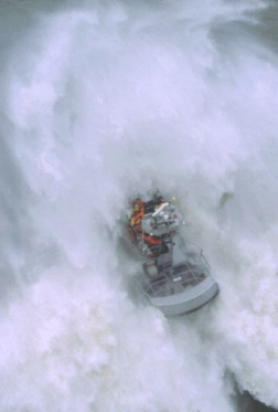
United States Coast Guard Station Cape Disappointment, situated near Cape Disappointment, Washington, at the mouth of the Columbia River, is the largest United States Coast Guard search and rescue station on the Northwest Coast, with 50 crewmembers assigned. Cape Disappointment Station is also the site of the oldest search and rescue station within the Thirteenth Coast Guard District. The station's Area of Responsibility reaches from Ocean Park on the Washington Coast south to Tillamook Head on the Oregon Coast.

The District of Oregon was a Union Army command department formed during the American Civil War.

The 8th Regiment California Volunteer Infantry was an infantry regiment in the Union Army during the American Civil War. Raised in the last year of the war, it spent its entire term of service serving in posts around San Francisco Bay, and on the Columbia River, attached to the Department of the Pacific, before mustering out in late 1865.
The Department of the Columbia was a major command (Department) of the United States Army during the 19th century.

The role of Washington Territory in the American Civil War is atypical, as the territory was the most remote from the main battlefields of the conflict. The territory raised a small number of volunteers for the Union Army, who did not fight against the Confederate States Army but instead maintained defensive positions against possible foreign naval or land attacks. Although the Indian Wars in Washington were recent, there were no Indian hostilities within the area of modern Washington, unlike the rest of the western states and territories, during the Civil War. At the start of the American Civil War, modern-day Washington was part of the Washington Territory. On March 3, 1863, the Idaho Territory was formed from that territory, consisting of the entirety of modern-day Idaho, Montana, and all but southwest Wyoming, leaving the modern-day Washington as Washington Territory.

Port Clarence Bay is a waterway in the U.S. state of Alaska. It has the only harbor and safe anchorage for large vessels in Seward Peninsula. The bay is located 25 miles southeast of York. It is a large body of comparatively deep water, nearly circular in outline, and cut off from the sea by a long, low sand spit, which terminates in Point Spencer at the entrance to the bay. Along the north side of Port Clarence Bay, there is a shallow lagoon, separated from the bay by a narrow sand spit. This lagoon extends several miles west of the entrance to Port Clarence. The hamlet of Port Clarence, Alaska is situated on the bay.

Baker Bay is a bay located just inside the mouth of the Columbia River, behind Cape Disappointment on the north side of the river, in Pacific County, Washington and Clatsop County, Oregon.


 A map of the Columbia River mouth, with Sand Island labeled