
Sanderstead Court was a country house in Sanderstead, Surrey, England, dating from at least the 17th century. It was destroyed by fire in 1944, and its ruins are Grade II listed.
Sanderstead Court was a country house in Sanderstead, Surrey, England, dating from at least the 17th century. It was destroyed by fire in 1944, and its ruins are Grade II listed.
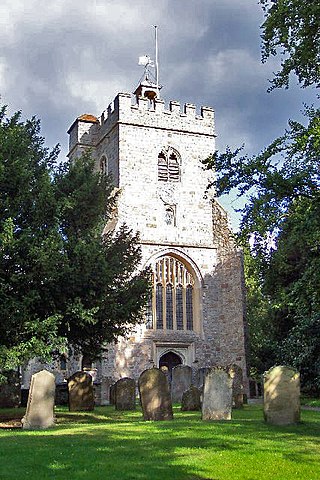
The building is located next to the All Saints' Parish Church (c. 1230) in Sanderstead. Sanderstead Court did not appear on the Tithe map of 1844. [1]
In 1675, the house was a three-story, red brick mansion comprising a central core with two large wings at either end which were adorned with decorated chimneys. The central portion of the house had a great room, two stories in height, supported by fluted columns with Corinthian capitals; this great room was probably originally constructed by an earlier Atwood in the 16th century. Many of the rooms in Sanderstead Court were panelled with wood. The Atwood shield with a lion rampant between three acorns, the initials “H.A.” (Harman Atwood) and the date “1675” were once were carved in stone over the main entry to Sanderstead Court.
John Preston Neale described the Sanderstead Court's grounds in 1818 by saying, "The site of the Court House is on an eminence, having in front a spacious lawn, skirted by a shrubbery of rich and varied foliage, separated from the adjoining pleasure grounds by a light range of iron palisades. The Park was enlarged by the addition of an Estate, called Place House; and the whole now forms quite a sequestered residence; the grounds, which are extensive, admit the most beautiful prospects: on one side are seen the counties of Buckinghamshire and Berkshire; and on the other, a fine open country for many miles, over all Bansted Downs" ( Neale 1818 ).
During World War II, it was used by the Royal Air Force. Sanderstead Court burned, leaving only the outside walls in 1944. As of 1947, the mansion was still standing but reduced to ruins. Part of it still remains as a Grade II listed building. [1] The grounds around the house have now been built on. These include Cedar Court [2] (three blocks of apartments) and a new Sanderstead Court (also three blocks of apartments).
Behind the house, was a stable building, this was used by Selsdon Park Golf Club as a clubhouse. [3] But the club later moved to Selsdon Park Hotel. The stables then formed part of the New Sanderstead Court apartments.
In 1346 Justice Peter Atte Wood (Atte Wode) and his wife Laurencia purchased land there ( Lewis 1894 , p. 338). Some time in the 15th century they moved to Sanderstead and began improving the property. ( Atwood 1928 ).
The Atwood family were benefactors to the Sanderstead Parish Church which was adjacent to their home, and John Atwood (Atwodde) and his wife, Denys, have a brass plaque in the church dated 1525. John’s grand son, Nicholas Wood-Atwood, who died in 1586, is identified as “of Sandersted Corte who served quene Elizabeth sens the second yearr of her rayne” on his brass in the church ( Stephanson 1919 ).
Nicholas Wood lost a portion of Sanderstead Court to Sir John Gresham, Lord Mayor of London. The Atwoods regained control of Sanderstead Court, and Nicholas Wood's son, Harman Atwood, Jr., transformed Sanderstead into a more significant country house when he made renovations in 1675. Harman Atwood left Sanderstead Court to his sister Dame Olivia Atwood. Olivia also died and the house passed through a succession of distant Atwood relations until it passed out of the family line entirely in 1759. Later owners included members of the Wigsell family. Edward Morton of C&E Morton (Isle of Dogs - canned food & preserves company) owner (unsure of timeline)

Selsdon is an area in South London, England, located in the London Borough of Croydon, in the ceremonial county of Greater London. Prior to 1965 it was in the historic county of Surrey. It now has the character of a suburb and sits at a high elevation, bordering downland.

Warlingham is a village and civil parish in the Tandridge district of Surrey, England, 14 miles (23 km) south of London and 22 miles (35 km) east of Guildford. Warlingham is the centre of a civil parish that includes Hamsey Green to the north. Caterham is 2 miles (3.2 km) to the southwest.

Ripley is a village and civil parish in Surrey, England. It is centred 6.2 miles (10.0 km) southeast of Woking, 6.8 miles (10.9 km) northeast of Guildford and 22.5 miles (36.2 km) southwest of London. Neighbouring villages Send and Send Marsh to the South-West and Ockham to the East have fewer shopping facilities.

Sanderstead is a village and medieval-founded church parish at the southern end of Croydon in south London, England, within the London Borough of Croydon, and formerly in the historic county of Surrey, until 1965. It takes in Purley Downs and Sanderstead Plantation, an area of woodland that includes the second-highest point in London. Sanderstead sits above a dry valley at the edge of the built-up area of Greater London. Cementing its secular identity from the late 19th century until abolition in 1965 it had a civil parish council. The community had a smaller farming-centred economy until the mid 19th century.

South Croydon in south London is the area surrounding the valley south of central Croydon and running as far south as the former Red Deer public house on the Brighton Road. It is bounded by Waddon to the West and Selsdon and Sanderstead to the East. It is part of the South Croydon (CR2) post town and in the London Borough of Croydon.

Hamsey Green is an area of Sanderstead in the Tandridge District of Surrey and partly in the London Borough of Croydon of Greater London, England. To the north is Sanderstead and Warlingham is to the south.

Westcott is a village in central Surrey, England, about 1.5 miles (2.5 km) west of the centre of Dorking. It is in the Mole Valley district and the Surrey Hills Area of Outstanding Natural Beauty. The Pipp Brook, a tributary of the River Mole, runs to the north of the centre and the settlement is between Ranmore Common on the North Downs and Leith Hill on the Greensand Ridge.

Compton is a village and civil parish in the Guildford district of Surrey, England. It is between Godalming and Guildford. It has a medieval church and a close connection to fine art and pottery, being the later life home of artist George Frederic Watts. The parish has considerable woodland and agricultural land, and the undeveloped portions are in the Metropolitan Green Belt. The village is traversed by the North Downs Way and has a large western conservation area. Central to the village are the Watts Gallery, the cemetery chapel commissioned by his wife for him, two inns and the parish church.

Godstone is a village and civil parish in the Tandridge District of Surrey, England. It is 6 miles (9.7 km) east of Reigate, 3 miles (4.8 km) west of Oxted, 22 miles (35 km) east of Guildford and 18 miles (29 km) south of London. Close to the North Downs and Blindley Heath. The Greensand Way and the North Downs Way both pass through Godstone.

Whyteleafe is a village in the district of Tandridge, Surrey, England, with a few streets falling inside the London Borough of Croydon. The village, in a dry valley of the North Downs, has three railway stations. Neighbouring villages and towns include Woldingham, Caterham, Coulsdon, Warlingham, and Kenley. To the west are Kenley Aerodrome, Kenley Common, Coxes Wood, and Blize Wood. To the east are Riddlesdown, the Dobbin and Marden Park.

Artington is a village and civil parish in the borough of Guildford, Surrey, England. It covers the area from the southern edge of the built-up centre of Guildford and steep Guildown, the start of the Hog's Back and part of the North Downs AONB, to New Pond Farm by Godalming and the edge of Peasmarsh. It contains Loseley Park, a country estate with dairy, and the hamlet of Littleton.

Headley is a village and civil parish in the North Downs in Surrey, England. The nearest settlements are, to the west, Mickleham and Leatherhead; to the north, Ashtead and Langley Vale; to the east, Walton-on-the-Hill; and to the south, Box Hill. It is just outside the M25 motorway encircling London.
Worplesdon is a village 3.1 miles (5.0 km) NNW of Guildford in Surrey, England and a large dispersed civil parish that includes the settlements of: Worplesdon itself, Fairlands, Jacobs Well, Rydeshill and Wood Street Village, all various-sized smaller settlements, well-connected by footpaths and local roads. Its area includes Whitmoor Common, which can be a collective term for all of its commons.
Downside is a small village in the English county of Surrey, in the local government district of Elmbridge, centred on Downside Common which is 18 miles (29 km) southwest of London and 8.4 miles (13.5 km) northeast of Guildford. Most of its buildings form a cluster. It has an inn, Downside Sports and Social Club, regular village hall events and an annual sports day. It is in the Cobham and Downside ward of Elmbridge Borough Council.
The list of known High Sheriffs of Surrey extends back to 1066. At various times the High Sheriff of Surrey was also High Sheriff of Sussex.
Peter Atte Wode was a Justice in Eyre for England south of the Trent from 1360–1367.
Sir William Atte Wode was Captain of the King's Guard at the Palace of Westminster under King Edward III of England.
John Atwood (1576–1644) was an assistant governor of the Plymouth Colony, in the future US state of Massachusetts, in 1638.

Selsdon Wood is a woodland area located in the London Borough of Croydon. The park is owned by the National Trust but managed by the London Borough of Croydon. It is a Local Nature Reserve. The wood has a Friends group – the Friends of Selsdon Wood (FSW) – who have their own website.
Chelsham is a village and former civil parish, now in the parish of Chelsham and Farleigh and the Tandridge district of Surrey, England. It is located in the Metropolitan Green Belt, 15.3 miles (24.6 km) from London, 3 miles (4.8 km) from Oxted and 23.8 miles (38.3 km) from Guildford. In 1961 the parish had a population of 1285.
51°20′10″N0°04′23″W / 51.336°N 0.073°W
| Settlements (grouped by associated post town) |
|  | ||||||||||||||||||
|---|---|---|---|---|---|---|---|---|---|---|---|---|---|---|---|---|---|---|---|---|
| Places of worship | ||||||||||||||||||||
| Education | ||||||||||||||||||||
| Transport |
| |||||||||||||||||||
| Buildings and structures |
| |||||||||||||||||||
| Sport |
| |||||||||||||||||||
The administrative centre is Oxted. The largest town is Caterham. Three of the post towns have urban centres Caterham, Godstone and Oxted. Lingfield and Warlingham are major villages which have post town status. The others are outside the area. | ||||||||||||||||||||