Related Research Articles

Wet Earth Colliery was a coal mine located on the Manchester Coalfield, in Clifton, Greater Manchester. The colliery site is now the location of Clifton Country Park. The colliery has a unique place in British coal mining history; apart from being one of the earliest pits in the country, it is the place where engineer James Brindley made water run uphill.

The Ingleton Coalfield is in North Yorkshire, close to its border with Lancashire in north-west England. Isolated from other coal-producing areas, it is one of the smallest coalfields in Great Britain.
The Astley and Tyldesley Collieries Company formed in 1900 owned coal mines on the Lancashire Coalfield south of the railway in Astley and Tyldesley, then in the historic county of Lancashire, England. The company became part of Manchester Collieries in 1929 and some of its collieries were nationalised in 1947.
Bedford Colliery, also known as Wood End Pit, was a coal mine on the Manchester Coalfield in Bedford, Leigh, Lancashire, England. The colliery was owned by John Speakman, who started sinking two shafts on land at Wood End Farm in the northeast part of Bedford, south of the London and North Western Railway's Tyldesley Loopline in about 1874. Speakman's father owned Priestners, Bankfield, and Broadoak collieries in Westleigh. Bedford Colliery remained in the possession of the Speakman family until it was amalgamated with Manchester Collieries in 1929.
Fletcher, Burrows and Company was a coal mining company that owned collieries and cotton mills in Atherton, Greater Manchester, England. Gibfield, Howe Bridge and Chanters collieries exploited the coal mines (seams) of the middle coal measures in the Manchester Coalfield. The Fletchers built company housing at Hindsford and a model village at Howe Bridge which included pithead baths and a social club for its workers. The company became part of Manchester Collieries in 1929. The collieries were nationalised in 1947 becoming part of the National Coal Board.
New Lester Colliery was a coal mine operating on the Manchester Coalfield from the second half of the 19th century to the first half of the 20th century in Tyldesley, then in the historic county of Lancashire, England. It was owned by James Roscoe and two shafts were sunk in about 1865 on the east side of Mort Lane on the road to Little Hulton where Roscoe had sunk the Peel Hall and New Watergate pits.
Bridgewater Collieries originated from the coal mines on the Manchester Coalfield in Worsley in the historic county of Lancashire owned by Francis Egerton, 3rd Duke of Bridgewater in the second half of the 18th century. After the Duke's death in 1803 his estate was managed by the Bridgewater Trustees until the 3rd Earl of Ellesmere inherited the estates in 1903. Bridgewater Collieries was formed in 1921 by the 4th Earl. The company merged with other prominent mining companies to form Manchester Collieries in 1929.

Astley Green Colliery was a coal mine in Astley, Greater Manchester, then in the historic county of Lancashire, England. It was the last colliery to be sunk in Astley. Sinking commenced in 1908 by the Pilkington Colliery Company, a subsidiary of the Clifton and Kersley Coal Company, at the southern edge of the Manchester Coalfield, working the Middle Coal Measures where they dipped under the Permian age rocks under Chat Moss. The colliery was north of the Bridgewater Canal. In 1929 it became part of Manchester Collieries, and in 1947 was nationalised and integrated into the National Coal Board. It closed in 1970, and is now Astley Green Colliery Museum.
Parsonage Colliery was a coal mine operating on the Lancashire Coalfield in Leigh, then in the historic county of Lancashire, England. The colliery, close to the centre of Leigh and the Bolton and Leigh Railway was sunk between 1913 and 1920 by the Wigan Coal and Iron Company and the first coal was wound to the surface in 1921. For many years its shafts to the Arley mine were the deepest in the country. The pit was close to the town centre and large pillars of coal were left under the parish church and the town's large cotton mills.
Pendlebury Colliery, usually called Wheatsheaf Colliery after the adjacent public house, was a coal mine operating on the Manchester Coalfield after 1846 in Pendlebury near Manchester, then in the historic county of Lancashire, England.
Nook Colliery was a coal mine operating on the Manchester Coalfield after 1866 in Tyldesley, Greater Manchester, then in the historic county of Lancashire, England.
Gin Pit was a coal mine operating on the Lancashire Coalfield from the 1840s in Tyldesley, Greater Manchester then in the historic county of Lancashire, England. It exploited the Middle Coal Measures of the Manchester Coalfield and was situated to the south of the Tyldesley Loopline.
Yew Tree Colliery was a coal mine operating on the Manchester Coalfield after 1845 in Tyldesley, Greater Manchester, then in the historic county of Lancashire, England.
Mosley Common Colliery was a coal mine originally owned by the Bridgewater Trustees operating on the Manchester Coalfield after 1866 in Mosley Common, Greater Manchester, then in the historic county of Lancashire, England. The colliery eventually had five shafts and became the largest colliery on the Lancashire Coalfield with access to around 270 million tons of coal under the Permian rocks to the south.
Linnyshaw Colliery or Berryfield was a coal mine originally owned by the Bridgewater Trustees operating after 1860 on the Manchester Coalfield in Walkden, Greater Manchester, then in the historic county of Lancashire, England.

Bradford Colliery was a coal mine in Bradford, Manchester, England. Although part of the Manchester Coalfield, the seams of the Bradford Coalfield correspond more closely to those of the Oldham Coalfield. The Bradford Coalfield is crossed by a number of fault lines, principally the Bradford Fault, which was reactivated by mining activity in the mid-1960s.

The Burnley Coalfield is the most northerly portion of the Lancashire Coalfield. Surrounding Burnley, Nelson, Blackburn and Accrington, it is separated from the larger southern part by an area of Millstone Grit that forms the Rossendale anticline. Occupying a syncline, it stretches from Blackburn past Colne to the Yorkshire border where its eastern flank is the Pennine anticline.

Bank Hall Colliery was a coal mine on the Burnley Coalfield in Burnley, Lancashire near the Leeds and Liverpool Canal. Sunk in the late 1860s, it was the town's largest and deepest pit and had a life of more than 100 years.
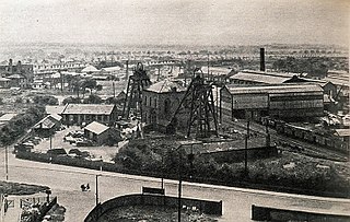
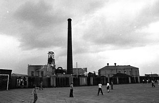
Ellesmere Colliery was a coal mine in Walkden, Manchester, England. The pit was located on Manchester Road, a short distance south of Walkden town centre.
References
Notes
- ↑ NW Division map, cmhrc.co.uk, archived from the original on 19 July 2011, retrieved 28 April 2011
- ↑ "Sandhole (or Bridgewater) Colliery (1865-1962) - Northern Mine Research Society". Northern Mine Research Society. Retrieved 24 October 2018.
- ↑ Atkinson 1998 , p. 51
- ↑ Hayes 2004 , p. 91
Bibliography
- Atkinson, Glen (1998), The Canal Duke's Collieries Worsley 1760-1900, Neil Richardson (Second Edition), ISBN 978-1-85216-120-0
- Hayes, Geoffrey (2004), Collieries and their Railways in the Manchester Coalfields, Landmark, ISBN 1-84306-135-X
Coordinates: 53°31′01″N2°22′26″W / 53.517°N 2.374°W
| | This United Kingdom location article is a stub. You can help Wikipedia by expanding it. |