
The River Severn, at 220 miles (354 km) long, is the longest river in Great Britain. It is also the river with the most voluminous flow of water by far in all of England and Wales, discharging an average of 107 m3/s (3,800 cu ft/s) into the Bristol Channel at Apperley, Gloucestershire. It rises in the Cambrian Mountains in mid Wales, at an altitude of 2,001 feet (610 m), on the Plynlimon massif, which lies close to the Ceredigion/Powys border near Llanidloes. The river then flows through Shropshire, Worcestershire and Gloucestershire. The three county towns of Shrewsbury, Worcester and Gloucester lie on its course.
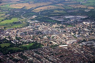
Gloucester is a cathedral city and district in Gloucestershire, of which it is the county town, in the South West of England. Gloucester lies on the River Severn, between the Cotswolds to the east and the Forest of Dean to the west, 19 miles (31 km) east of Monmouth, and 17 miles (27 km) east of the border with Wales. Including suburban areas, Gloucester has a population of around 150,000. It is a port, linked via the Gloucester and Sharpness Canal to the Severn Estuary.

Thornbury is a market town and civil parish in the South Gloucestershire district of the county of Gloucestershire, England, about 12 miles north of Bristol. It had a population of 12,063 at the 2011 Census. Thornbury is a Britain in Bloom award-winning town, with its own competition: Thornbury in Bloom. Nearby villages include Morton and Thornbury Park. The civil parish includes the hamlet of Milbury Heath.
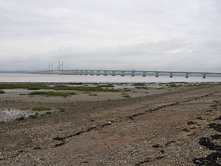
Severn Beach is a village on the Severn Estuary in South Gloucestershire, England. The eastern portal of the Severn Tunnel is on the outskirts of the village. The Severn footpath – on the sea wall – is part of the Severn Way that leads from Gloucester, Slimbridge and the Second Severn Crossing. Extensive sea defences have been constructed in recent years and this provides a popular walkway along its length. Originally, the Severn Way finished at Severn Beach, but it has recently been extended to Bristol.

Forest of Dean is a local government district in Gloucestershire, England, named after the Forest of Dean. Its council is based in Coleford. Other towns and villages in the district include Blakeney, Cinderford, Drybrook, English Bicknor, Huntley, Littledean, Longhope, Lea, Lydbrook, Lydney, Mitcheldean, Newnham and Newent.

Hucclecote is a village in Gloucestershire, United Kingdom, comprising a ward in the City of Gloucester, and an adjacent civil parish in the Borough of Tewkesbury. It is located on the periphery of the city, between Barnwood and Brockworth, along Ermin Way, an old Roman road connecting Gloucester with Cirencester and the Cotswolds.
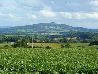
May Hill is a prominent English hill between Gloucester and Ross-on-Wye. Its summit, on the western edge of Gloucestershire and its northern slopes in Herefordshire, is readily distinguishable by a clump of trees on its summit, which forms an official Site of Special Scientific Interest. It is reached by three public footpaths, two forming parts of the Gloucestershire Way and Wysis Way.
Frampton on Severn is a village in Gloucestershire, England. There is a parish council, consisting of nine members. The total population is 1,432.

Newnham or Newnham on Severn is a village in west Gloucestershire, England. It lies in the Royal Forest of Dean, on the west bank of the River Severn, approximately 10 miles south-west of Gloucester and three miles southeast of Cinderford. It is on the A48 road between Gloucester and Chepstow, Monmouthshire, Wales. The village has a parish council.

Minsterworth is a village in Gloucestershire, England. It lies on the border of the City of Gloucester, on the north bank of the River Severn and on the A48 road between Gloucester and Chepstow.

Hardwicke is a village on the A38 road some 4 miles / 7 km south of the city of Gloucester, Gloucestershire, England. The area is often dubbed 'The Hollywood of Gloucester' but despite its proximity to Gloucester, the village is within the jurisdiction and boundaries of Stroud (district) Council. The population of the village taken at the United Kingdom Census 2011 was 3,901.

Quedgeley is a suburban town or modern village suburb 3.5 miles (5.6 km) southwest of the city of Gloucester, England. A thin strip of land between the Severn and the Gloucester Ship Canal occupies the west, and the south-eastern part of the town is Kingsway Village, directly to the north of which is Tuffley.
Arlingham is a village and civil parish in the Stroud District of Gloucestershire, England. The 2001 Census recorded a parish population of 410, increasing to 459 at the 2011 census. The parish contains the hamlets of Milton End, Overton and Priding The next parish to the east is Fretherne with Saul.

Westbury-on-Severn is a rural village in England that is the centre of the large, rural parish, also called Westbury-on-Severn.

Ramat Hovav, new official name Ne'ot Hovav, is an industrial zone in southern Israel and the site of Israel's main hazardous waste disposal facility. Ramat Hovav Industrial Zone is the locus of 19 chemical factories, including Makhteshim Agan, a pesticide plant; Teva Pharmaceutical Industries, a pharmaceuticals plant; Israel Chemicals, a bromine plant.

Maisemore is a village and civil parish in Gloucestershire, England. It lies on the A417 road 2.5 miles (4 km) northwest of Gloucester, on the west bank of the River Severn. In the 2001 census the parish had a population of 488, reducing to 458 at the 2011 census.

The Westgate area of Gloucester is centred on Westgate Street, one of the four main streets of Gloucester and one of the oldest parts of the city. The population of the Westgate ward in Gloucester was 6,687 at the time of the 2011 Census.
Moreton Valence is a village 6 miles (9.7 km) south-west of Gloucester, Gloucestershire, England, on the A38. It lies on the river Severn and the Gloucester and Sharpness Canal. The Parkend Canal bridge is in the middle of Moreton Valence, with the Parkend Bridge House which is a Grade II listed building. The estimated population of the civil parish in 2016 was 165.

Thomas Fulljames FRIBA was an architect active in Gloucestershire, England, in the first half of the nineteenth century. As diocesan surveyor from 1832 until 1870, latterly in partnership with Frederick Sandham Waller, he designed, reconstructed or extended a number of churches in Gloucestershire.

