
Unnao is a city in the Indian state of Uttar Pradesh. It is the administrative headquarters of Unnao district and a part of Lucknow division, between Kanpur and Lucknow. Unnao is a large industrial city with three industrial suburbs around it. Unnao has the country's largest leather Export in the UPSIDC.

Unnao district is a district of Uttar Pradesh state in northern India. The city of Unnao is the district headquarters. The district is part of Lucknow Division.

Raebareli district is a district of Uttar Pradesh state in northern India. The city of Raebareli is the district headquarters. This district is a part of Lucknow Division in Uttar Pradesh state. The total area of Raebareli district is 3,371 Sq. km.
Badarka, founded in 1643 CE, is a village & gram panchayat in Unnao tehsil of Unnao sub-district of Unnao district in Uttar Pradesh state of India. It is situated 15 km south of Unnao city between Ata & Lohcha villages on Kanpur-Raibareli road. The village is famed for being the native place of the renowned freedom fighter Chandrasekhar Azad and his parents - father Pandit Sitaram Tiwari and mother Jagrani Devi.
Maurawan, also spelled Mauranwan, is a town and nagar panchayat in Purwa tehsil of Unnao district, Uttar Pradesh, India. It is located 12 km from Purwa on the road to Raebareli, and 3 km to the southwest of the town is the large Basaha lake. As of 2011, its population is 15,484, in 2,399 households.

Purwa is a town and nagar panchayat in Unnao district, Uttar Pradesh, India. It is located 32 km southeast of Unnao, the district headquarters. Roads connect it with several major cities including Unnao, Lucknow, Kanpur, and Rae Bareli. As of 2011, its population is 24,467 people, in 4,128 households.
Patan is a town in Sumerpur block of Unnao District in the state of Uttar Pradesh, India. It is located 16km south of Purwa on the main Unnao-Allahabad road, and a short distance to the south of the Loni river. Part of the historical region of Baiswara, it historically gave its name to a pargana which existed since at least the time of Akbar, and under the Nawabs of Awadh it was the seat of a tehsil. The Rae Bareli-Kanpur branch of the Northern Railway zone runs through Patan, and the Takia train station is located in the village. A huge fair called the Takia-ka-Mela is held in Patan on the first Thursday in Paus, in honour of the saint Niamat Shah, revered by both Hindus and Muslims, drawing tens of thousands of visitors. A second fair, established by Muhabbat Shah's disciple Shafqat Shah, is also held in Muhabbat Shah's honour at the tomb on the first Thursday of Jeth.
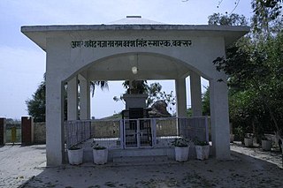
Raja Rao Ram Baksh Singh was a Bais Rajput Raja Rao of Daundia Khera in Unnao district of Uttar Pradesh in the then Oudh province that was a vassal state of the British East India Company. He was one of the leaders of the Sepoy Mutiny, and a close associate of Nana Sahib. He was hanged by the British on 28 December 1857 for taking part in the revolt and being found guilty of the killing of British soldiers. In 1992, the Government of India built a memorial at the place where he was hanged to honor his death.

Asoha is a village in Purwa tehsil of Unnao district, Uttar Pradesh, India. It is located about 16 km north of Purwa, the tehsil headquarters, and 51 km east of Unnao, the district headquarters. The main crops grown here are wheat, barley, gram, juwar, paddy, and pulses, and irrigation is provided by a canal as well as by tanks. The soil here is mostly clay. As of 2011, the population of Asoha is 3,709, in 856 households.
Kishan Khera is a village in Purwa block of Unnao district, Uttar Pradesh, India. It is not connected to major district roads and has one primary school and one medical practitioner. As of 2011, its population is 845, in 177 households.

Mawai is a village in Hilauli block of Unnao district, Uttar Pradesh, India. As of 2011, its population is 14,690, in 2,734 households, and it has 8 primary schools and one medical clinic. It hosts a regular market and has a post office.
Panhan, also called Panhan Khas, is a small village in Purwa block of Unnao district, Uttar Pradesh, India. Located due south of Purwa and a bit to the west of the Loni River, it historically was the seat of a pargana. As of 2011, the village's population is 545 people, in 104 households.

Sumerpur is a hamlet of the village Chhanchhi Rai Khera, in Purwa tehsil of Unnao district, Uttar Pradesh, India. Located 26km south of Purwa and 50km southeast of Unnao, Sumerpur serves as the headquarters of a community development block as well as a nyaya panchayat. Sumerpur block was first established on 2 October 1955 in order to oversee implementation of India's Five-Year Plans at a local and rural level. As of 2011, the block comprises 148 villages and has a total population of 151,933 people in 28,469 households.
Bihar is a village in Sumerpur block of Unnao district, Uttar Pradesh, India. Located on the main Unnao-Raebareli road, just to the east of the Loni river and near its confluence with the Kharahi, Bihar was briefly the headquarters of a tehsil in Raebareli district from 1860 until 1862, when it was moved into Unnao district. As of 2011, the population of Bihar is 5,952, in 1,088 households, and it has 5 primary schools and no healthcare facilities.

Hardaspur is a village in Amawan block of Rae Bareli district, Uttar Pradesh, India. As of 2011, its population is 2,974, in 570 households. It has 3 primary schools and one small clinic.

Murarmau is a village in Sareni block of Rae Bareli district, Uttar Pradesh, India. It is located 21 km from Lalganj, the tehsil headquarters. Murarmau historically served as the seat of the largest taluqdar estate in the district, held by the most senior branch of the Tilokchandi Bais. As of 2011, it has a population of 2,999 people, in 523 households. It has one primary school and no healthcare facilities. Murarmau serves as the headquarters of a nyaya panchayat which also includes 9 other villages.

Simarpaha is a village in Lalganj block of Rae Bareli district, Uttar Pradesh, India. It is located 3 km southwest of Lalganj on the road to Ralpur on the Ganges. In addition to the main site, the village also includes several dispersed hamlets. Simarpaha was historically the seat of a taluqdari estate held by a branch of the Bais Rajputs. As of 2011, it has a population of 8,391 people, in 1,501 households. It has two primary schools and no healthcare facilities.

Paho, also spelled Pahu, is a village in Khiron block of Rae Bareli district, Uttar Pradesh, India. It is located near the road from Raebareli to Mauranwan and Unnao, close to the border with Unnao district. It is 18 km away from Lalganj, the tehsil headquarters. As of 2011, Paho has a population of 5,620 people, in 1,088 households. It has two primary schools and no healthcare facilities, and it hosts a weekly haat but not a permanent market. It is the seat of a nyaya panchayat which also includes 7 other villages.
Khajurgaon is a village in Lalganj block of Rae Bareli district, Uttar Pradesh, India. It is located on the bank of the Ganges, 12 km from Lalganj, the block and tehsil headquarters. As of 2011, it has a population of 5,916 people, in 1,067 households. It has 5 primary schools and 1 community health centre. It serves as the headquarters of a nyaya panchayat which also includes 12 other villages.
Rana Beni Madho or Beni Madho Baksh Singh Bais was one of the most important leaders in the Indian rebellion of 1857 from the Oudh region. He belonged to the Bais clan of Rajputs and was the ruler of the Shankarpur estate in modern-day Rae Bareli, part of the old Baiswara region in Oudh. He led a rebellion against the British forces in 1857. His son was married to the grand daughter of another prominent revolutionary leader Kunwar Singh of Jagdishpur estate.

