The San Luis Valley is a region in south-central Colorado with a small portion overlapping into New Mexico. The valley is approximately 122 miles (196 km) long and 74 miles (119 km) wide, extending from the Continental Divide on the northwest rim into New Mexico on the south. It contains 6 counties and portions of 3 others. It is an extensive high-elevation depositional basin of approximately 8,000 square miles (21,000 km2) with an average elevation of 7,664 feet (2,336 m) above sea level. The valley is a section of the Rio Grande Rift and is drained to the south by the Rio Grande, which rises in the San Juan Mountains to the west of the valley and flows south into New Mexico. The San Luis Valley has a cold desert climate but has substantial water resources from the Rio Grande and groundwater.

Costilla County is a county located in the U.S. state of Colorado. As of the 2020 census, the population was 3,499. The county seat is San Luis, the oldest continuously occupied town in Colorado.

The Town of Hooper is a Statutory Town located in the San Luis Valley in Alamosa County, Colorado, United States. The population was 81 at the 2020 census.

Salida is the statutory city that is the county seat and the most populous municipality of Chaffee County, Colorado, United States. The population was 5,666 at the 2020 census.
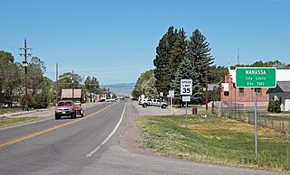
Founded in 1851, the Town of Manassa is a Statutory Town and is the most populous municipality in Conejos County, Colorado, United States. The town's population was 947 at the 2020 United States Census.

Fort Garland is an unincorporated town, a post office, and a census-designated place (CDP) located in and governed by Costilla County, Colorado, United States. The Fort Garland post office has the ZIP Code 81133. At the United States Census 2020, the population of the Fort Garland CDP was 464.

San Luis is a statutory town that is the county seat and the most populous town of Costilla County, Colorado, United States. Formerly known as San Luis de la Culebra, it is the oldest continuously occupied town in Colorado. The population was 598 at the 2020 census.

Acres Green is an unincorporated community and a census-designated place (CDP) located in and governed by Douglas County, Colorado, United States. The CDP is a part of the Denver–Aurora–Lakewood, CO Metropolitan Statistical Area. The population of the Acres Green CDP was 2,922 at the 2020 United States Census. The community lies in ZIP Code 80124.
Sangre de Cristo can refer to:

The Sangre de Cristo Mountains are the southernmost subrange of the Rocky Mountains. They are located in southern Colorado and northern New Mexico in the United States. The mountains run from Poncha Pass in South-Central Colorado, trending southeast and south, ending at Glorieta Pass, southeast of Santa Fe, New Mexico. The mountains contain a number of fourteen thousand foot peaks in the Colorado portion, as well as several peaks in New Mexico which are over thirteen thousand feet.
Blanca Peak is the fourth highest summit of the Rocky Mountains of North America and the U.S. state of Colorado. The ultra-prominent 14,351-foot (4,374 m) peak is the highest summit of the Sierra Blanca Massif, the Sangre de Cristo Range, and the Sangre de Cristo Mountains. The fourteener is located 9.6 miles (15.5 km) north by east of the Town of Blanca, on the drainage divide separating Rio Grande National Forest and Alamosa County from the Sangre de Cristo Land Grant and Costilla County. The summit is the highest point of both counties and the entire drainage basin of the Rio Grande. Below the steep North Face of Blanca Peak two live Glaciers once developed, until extinction sometime after 1903. North & South Blanca Glaciers were located at 37° 35N.,longitude 105° 28W. Blanca Peak is higher than any point in the United States east of its longitude.

Mount Lindsey is a high mountain summit on the Sierra Blanca Massif in the Sangre de Cristo Range of the Rocky Mountains of North America. The 14,048-foot (4,282 m) fourteener is located in the Sangre de Cristo Land Grant, 10.8 miles (17.4 km) north of the community of Fort Garland in Costilla County, Colorado, United States.

San Isabel National Forest is located in central Colorado. The forest contains 19 of the state's 53 fourteeners, peaks over 14,000 feet (4,267 m) high, including Mount Elbert, the highest point in Colorado.

Coaldale is a census-designated place (CDP) and post office located in and governed by Fremont County, Colorado, United States. The CDP is a part of the Cañon City, CO Micropolitan Statistical Area. The Coaldale post office has the ZIP Code 81222. At the United States Census 2020, the population of the Coaldale CDP was 343.

Howard is a census-designated place (CDP) and post office in and governed by Fremont County, Colorado, United States. The CDP is a part of the Cañon City, CO Micropolitan Statistical Area. The Howard post office has the ZIP Code 81233. At the United States Census 2020, the population of the Howard CDP was 852.
San Pablo is an unincorporated community located in Costilla County, Colorado, United States. The San Luis post office (Zip Code 81152) serves San Pablo postal addresses. San Pablo is located in the Rio Culebra valley of the Sangre de Cristo Land Grant which was awarded to the family of Carlos Beaubien in 1843.

San Acacio is an unincorporated community and a census-designated place (CDP) located in and governed by Costilla County, Colorado, United States. The population of the San Acacio CDP was 56 at the 2020 United States census. The Sanford post office serves San Acacio postal addresses.

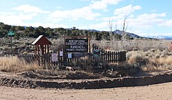
Vermejo Park Ranch, Vermejo Ranch, or Vermejo, is a 550,000-acre (220,000 ha) nature reserve and guest ranch in northeastern New Mexico and southern Colorado. Ted Turner Reserves, the luxury hospitality company founded by Ted Turner, includes conservation research and ecosystem restoration along with guest operations. The reserve, which stretches from the Great Plains at an elevation of 5,867 ft (1,788 m) to the summit of the Sangre de Cristo Mountains, reaches an elevation of 12,931 ft (3,941 m). The ranch produces significant quantities of coalbed methane, a type of natural gas.
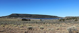
Mountain Home Reservoir is a reservoir and state wildlife area in Costilla County, Colorado, near Fort Garland. Frozen in winter, the reservoir lies at 2,483 meters elevation on the western slope of the Culebra Range of the Sangre de Cristo Mountains in southern Colorado.
The Sangre de Cristo Land Grant in the San Luis Valley of southern Colorado and northern New Mexico consists of 1,000,000 acres (4,000 km2) of mostly arid land. It was awarded by the government of New Mexico to the Beaubien family in 1843. The land grant was originally settled by Hispanics from New Mexico. Since the incorporation of the area of the grant into the United States in 1848, legal disputes between the descendants of the Hispanic settlers and Anglo ranchers about ownership of and access to some of the land in the grant area have been frequent and continued into the 21st century.