
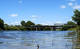
Matamata is a town in the Waikato region of New Zealand's North Island. It is located near the base of the Kaimai Ranges, and is a thriving farming area known for Thoroughbred horse breeding and training pursuits. It is part of the Matamata-Piako District, which takes in the surrounding rural areas as well as Morrinsville and Te Aroha. State Highway 27 and the Kinleith Branch railway run through the town. The town has a population of 7,910 as of June 2019.

Foxton is a town in the Manawatu-Wanganui region of New Zealand - on the lower west coast of the North Island, in the Horowhenua district, 30 km (19 mi) southwest of Palmerston North and just north of Levin. The town is located close to the banks of the Manawatu River. It is situated on State Highway 1, roughly in the middle between Tongariro National Park and Wellington.
Ngāruawāhia is a town in the Waikato region of the North Island of New Zealand. It is located 20 kilometres (12 mi) north-west of Hamilton at the confluence of the Waikato and Waipa Rivers, adjacent to the Hakarimata Range. Ngāruawāhia lies within the Hamilton Urban Area, the fourth largest urban area in New Zealand. The location was once considered as a potential capital of New Zealand.

Manawatū-Whanganui is a region in the lower half of the North Island of New Zealand, whose main population centres are the cities of Palmerston North and Whanganui. It is administered by the Manawatū-Whanganui Regional Council, which operates under the name Horizons Regional Council.

The suburb of Plimmerton lies in the northwest part of the city of Porirua in New Zealand, adjacent to some of the city's more congenial beaches. State Highway 1 and the North Island Main Trunk railway line pass just east of the main shopping and residential area.
Putāruru is a small town in the South Waikato District of Waikato region of New Zealand's North Island. It lies on the western side of the Mamaku Ranges, on the upper basin of the Waihou River. It is on the Oraka Stream 65 kilometres south-east of Hamilton. Both New Zealand State Highway 1 and the Kinleith Branch railway run through the town. The actual Māori-language origin of the town's name is thought to be the word Putaaruru – "To come forth like a ruru (morepork)"; sometimes translated as 'Home of the Owl'.
Himatangi is a small settlement in the Manawatu-Wanganui region of New Zealand's North Island. It is located at the junction of State Highways 1 and 56, 25 kilometres west of Palmerston North, and seven kilometres east of the coastal settlement of Himatangi Beach.
Linton is a suburb of Palmerston North, situated 11km south-west of the city.
The Sanson Tramway in the Manawatu region of New Zealand operated from 1885 until 1945. Owned by the Manawatu County Council, it connected with the national railway network at Himatangi on the Foxton Branch. It was never part of the national network.
Kelvin Grove is a suburb of Palmerston North on New Zealand's North Island. It is bounded on the north by the North Island Main Trunk railway, Manawatu District and Milson, on the west by Palmerston North–Gisborne Line and Roslyn, the south by the Manawatu River, and the east by James Line and Whakarongo.
Longburn is a rural settlement just outside Palmerston North in the Manawatū-Whanganui area of New Zealand. Made up of large dairy processing plants Longburn is often mistaken to be a small township and not seen as a large satellite town of Palmerston North. The township is home to both Longburn School and Longburn Adventist College.

Halcombe is a small settlement in the Manawatu-Wanganui region of the North Island, New Zealand. It is situated 13km north west of Feilding and 4km east of the Rangitikei River, between State Highway 1 and State Highway 54.
Rongotea is a small rural township in the Manawatu District of the Manawatū-Whanganui region. Located on the western Manawatu Plains, approximately 19 km (12 mi) northwest of the region's main city, Palmerston North.
Whatawhata, previously also spelt Whata Whata, is a small town in the Waikato region on the east bank of the Waipa River, at the junction of State Highways 23 and 39, 12 km (7.5 mi) from Hamilton. Te Araroa Trail passes through Whatawhata.
Aramoho is a settlement on the Whanganui River, in the Whanganui District and Manawatū-Whanganui region of New Zealand's North Island. It is an outlying suburb of Whanganui.
Putiki or Pūtiki is a settlement in the Whanganui District and Manawatū-Whanganui region of New Zealand's North Island, located across the Whanganui River from the Wanganui township. It includes the intersection of State Highway 3 and State Highway 4.
Rukuhia is a rural community in the Waipa District and Waikato region of New Zealand's North Island.
Mataroa is a settlement in the Rangitikei District and Manawatū-Whanganui region of New Zealand's North Island.
Rangiotu is a farming community in the Manawatu District and Manawatū-Whanganui region in New Zealand's central North Island.

