
Francis Marion, also known as the Swamp Fox, was a military officer who served in the American Revolutionary War (1775–1783). Acting with the Continental Army and South Carolina militia commissions, he was a persistent adversary of the British in their occupation of South Carolina and Charleston in 1780 and 1781, even after the Continental Army was driven out of the state in the Battle of Camden. Marion never commanded a large army or led a major battle. He used irregular methods of warfare and is considered one of the fathers of modern guerrilla warfare and maneuver warfare, and is credited in the lineage of U.S. Army Rangers and the 75th Ranger Regiment.

Clarendon County is a county located below the fall line in the Coastal Plain region of U.S. state of South Carolina. As of 2010, its population was 34,971. Its county seat is Manning.

Moncks Corner is a town in and the county seat of Berkeley County, South Carolina, United States. The population was 7,885 at the 2010 census. As defined by the U.S. Census Bureau, Moncks Corner is included within the Charleston-North Charleston-Summerville Metropolitan Statistical Area.

Kingstree is a city and the county seat of Williamsburg County, South Carolina, United States. The population was 3,328 at the 2010 census.

Chota is a historic Overhill Cherokee town site in Monroe County, Tennessee, in the southeastern United States. Developing after nearby Tanasi, Chota was the most important of the Overhill towns from the late 1740s until 1788. It replaced Tanasi as the de facto capital, or 'mother town' of the Cherokee people.
The Cherokee Path was the primary route of English and Scots traders from Charleston to Columbia, South Carolina in Colonial America. It was the way they reached Cherokee towns and territories along the upper Keowee River and its tributaries. In its lower section it was known as the Savannah River. They referred to these towns along the Keowee and Tugaloo rivers as the Lower Towns, in contrast to the Middle Towns in Western North Carolina and the Overhill Towns in present-day southeastern Tennessee west of the Appalachian Mountains.
The Santee tribe were a historical tribe of Siouan-language speakers from South Carolina. Historically the Santee were a small tribe, and centered in the area of the present town of Santee, South Carolina. Their settlement was along the Santee River, since dammed and called Lake Marion.
Santee National Wildlife Refuge is a 15,000-acre (61 km2) refuge alongside Lake Marion, an impoundment of the Santee River of Clarendon County, South Carolina.
Ninety Six National Historic Site, also known as Old Ninety Six and Star Fort, is a United States National Historic Site located about 60 miles south of Greenville, South Carolina. The historic site was listed on the National Register in 1969, declared to be a National Historic Landmark in 1973, and established as a National Historic Site in 1976 to preserve the original site of Ninety Six, South Carolina, a small town established in the early 18th century. It encompasses 1,022 acres of property.
Big Mound City (8PB48) is a prehistoric site near Canal Point, Florida, United States. It is located 10 miles east of Canal Point, off U.S. Route 98. On May 24, 1973, it was added to the U.S. National Register of Historic Places. It is located inside the J.W. Corbett Wildlife Management Area.
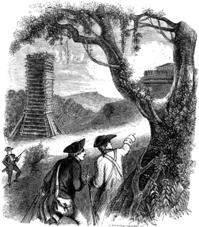
The siege of Fort Watson was an American Revolutionary War confrontation in South Carolina that began on April 15, 1781 and lasted until April 23, 1781. Continental Army forces under Henry "Light Horse Harry" Lee and South Carolina militia under Francis Marion besieged Fort Watson, a fortified British outpost that formed part of the communication and supply chain between Charleston and other British outposts further inland.

Pinewood Depot is an historic railway station located at the junction of East Avenue and Clarke Street in the town of Pinewood, at the southern entrance of the High Hills of Santee, South Carolina. It is the only railroad station left in Sumter County, but is not longer used by CSX, the current owner of the railroad right-of-way. On June 10, 1997, it was added to the National Register of Historic Places.

The Spikebuck Town Mound and Village Site is a prehistoric and historic archaeological site on Town Creek near its confluence with the Hiwassee River within the boundaries of present-day Hayesville, North Carolina. The site encompasses the former area of the Cherokee village of Quanassee and associated farmsteads. The village was centered on what is known as Spikebuck Mound, an earthwork platform mound, likely built about 1,000 CE by ancestral indigenous peoples during the South Appalachian Mississippian culture period.

Too-Cowee, was an important historic Cherokee town located near the Little Tennessee River north of present-day Franklin, North Carolina. It also had a prehistoric platform mound and earlier village built by ancestral peoples. As their expression of public architecture, the Cherokee built a townhouse on top of the mound. It was the place for their community gatherings in their highly decentralized society. The name translates to "pig fat" in English. British traders and colonists referred to Cowee as one of the Cherokee Middle Towns along this river; they defined geographic groupings based in relation to their coastal settlements, such as Charlestown, South Carolina.
The Adamson Mounds Site (38KE11) is an archaeological site located near Camden, Kershaw County, South Carolina. It is a prehistoric Native American village site containing one large platform mound, a smaller mound, possibly a third still smaller mound, and a burial area. It served as a regional ceremonial center. This site represents a widespread, late prehistoric Mississippian culture known by the names of Lamar, Irene, or Pee Dee and dates probably between AD 1400 and AD 1700.
The McDowell Site, also known as Chesnut Mounds, Taylor Mounds, and Mulberry Plantation House, is a set of historic mounds located near Camden, Kershaw County, South Carolina. The McDowell Site is among the first archaeological sites to be carefully excavated and archaeologically reported in the United States. It represents a widespread late prehistoric Indian culture known by the names of Lamar, Irene, and Pee Dee, and possibly extends into protohistoric and historic times. It probably dates between AD 1400 and AD 1700.
Nununyi was a historic village of the Cherokee people in western North Carolina, located on the eastern side of the Oconaluftee River. Today it is within the boundaries of the present-day city of Cherokee in Swain County. It was classified by English traders and colonists as among the "Out Towns" of the Cherokee in this area east of the Appalachian Mountains.

The Fort Vengeance Monument Site is an archaeological and commemorative site on United States Route 7 in northern Pittsford, Vermont. The site includes the archaeological remains of one of Vermont's oldest documented homesteads, and the only surviving site of a military fortification of the American Revolutionary War. The site is marked by a stone memorial placed in 1873, and was listed on the National Register of Historic Places in 2006.
Fort Juelson, designated 21OT198 in the state archaeological inventory, is a historic site located east of Underwood, Minnesota, United States. An earthen fort was built at this hilltop in July 1876 after rumors of Indian attacks in Foxhome, French, and Fergus Falls following the Battle of Little Bighorn in Montana. Many settlers left the area. Charles A. Dollner, a local merchant, suggested the rest of the people band together and build the fortification under leadership of two American Civil War veterans, Hans Juelson and Berge O. Lee. The scare proved to be a hoax, and the fort was never used for defensive purposes. Remnants of the sod barricade are still on the site.
North Santee is a census-designated place (CDP) in Clarendon County, South Carolina, United States. It was first listed as a CDP prior to the 2020 census with a population of 749.


