Highway 60 is a provincial highway in the Canadian province of Saskatchewan. It runs from Highway 7 near Saskatoon to Pike Lake Provincial Park. The highway is approximately 23 km (14 mi) long. This route primarily serves as a link connecting Saskatonians to Pike Lake and its campground, though it is also an important local road for acreages and businesses in the area. The speed limit is 90 km/h (55 mph). The Saskatchewan Railway Museum is located at the Hawker Siding about 3 km from Highway 7. Hawker Siding was previously known as Eaton Siding. A Ukrainian church is farther south on the highway.
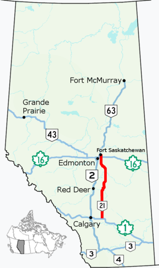
Alberta Provincial Highway No. 21, commonly referred to as Highway 21, is a north–south highway in Alberta, Canada that parallels Highway 2 between Calgary and Edmonton. It is approximately 328 kilometres (204 mi) in length. It begins at the Trans-Canada Highway (Highway 1) east of Strathmore, and ends at Fort Saskatchewan where it is succeeded by Highway 15. The northernmost 25 kilometres (16 mi) of the highway are twinned. Highway 21 runs roughly parallel to the main north–south CN rail line between Calgary and Edmonton between Three Hills and Looma.

The Fishing Lakes, also called the Calling Lakes or the Qu'Appelle Lakes, are a chain of four lakes in the Qu'Appelle Valley cottage country about 40 miles (64 km) to the north-east of Regina in the Canadian province of Saskatchewan. The lakes are in a region called the Prairie Pothole Region of North America, which extends throughout three Canadian provinces and five U.S. states. It is also within Palliser's Triangle and the Great Plains ecoregion. The Fishing Lakes all follow the course of the Qu'Appelle River, which flows from the west to the east and is part of the Hudson Bay drainage basin. The lakes sit in the deep-cut Qu'Appelle Valley that was formed about 14,000 years ago during the last ice age. Meltwater from the glaciers carved out the valley and as water levels rose and fell, alluvium was left in the wake. These piles of alluvium are what created the separations between the lakes.
Highway 365 is a provincial highway in the Canadian province of Saskatchewan. It connects Highway 2 in the town of Watrous, Manitou Beach regional park, to Highway 16 at Plunkett. It is about 35 kilometres (22 mi) long.
Highway 6 is a paved undivided major provincial highway in the Canadian province of Saskatchewan. It runs from Montana Highway 16 at the Canada–US border near the Canada customs port of Regway to Highway 55 near Choiceland. Highway 6 is about 523 km (325 mi) long. The CanAm Highway comprises Saskatchewan Highways from south to north: SK 35, Sk 39, Sk 6, Sk 3, as well as Sk 2. 330 kilometres (210 mi) of Saskatchewan Highway 6 contribute to the CanAm Highway between Corinne and Melfort.
Highway 4 is a major highway in the Canadian province of Saskatchewan. It runs from U.S. Route 191 at the United States border near Monchy to Highway 224 / Highway 904 in Meadow Lake Provincial Park. Highway 4 is about 652 km (405 mi) long.
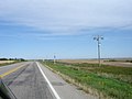
Highway 56 is a provincial highway in the Canadian province of Saskatchewan. It runs from Highway 1 near Indian Head to Highway 210 within the Echo Valley Provincial Park. Highway 56 is about 55 km (34 mi) long.

Highway 301 is a highway in the Canadian province of Saskatchewan. It runs from the Highway 1 / Highway 39 intersection near Pasqua to Highway 202 near Buffalo Pound Provincial Park and passes through the community of Pleasant Mount. It is about 21 kilometres (13 mi) long.
Highway 212 is a provincial highway in the Canadian province of Saskatchewan. Saskatchewan's 200-series highways primarily service its recreational areas. The highway runs from Highway 11 / Highway 783 near Duck Lake to the Fort Carlton Provincial Historic Park. It passes through Titanic, connects with Highway 683, and is about 26 kilometres (16 mi) long.

The Rural Municipality of North Qu'Appelle No. 187 is a rural municipality (RM) in the Canadian province of Saskatchewan within Census Division No. 6 and SARM Division No. 1. It is located in the south-east portion of the province.
Highway 21 is a highway in the Canadian province of Saskatchewan. It runs from Montana Secondary Highway 233 at the United States border near Willow Creek to Highway 950/Highway 919 within the Meadow Lake Provincial Park. Highway 21 is about 715 km (444 mi) long.

Highway 35 is a paved undivided provincial highway in the Canadian province of Saskatchewan.. It runs from the US Border near Port of Oungre to a dead end near the north shore of Tobin Lake. Saskatchewan Highway 35 (SK Hwy 35) is about 569 kilometres (354 mi) long. The CanAm Highway comprises Saskatchewan Highways 35, SK Hwy 39, SK Hwy 6, SK Hwy 3, SK Hwy 2 and U.S. Route 85. 74.6 kilometres (46.4 mi) of SK Hwy 35 contribute to the CanAm Highway between Port of Oungre on the Canada – United States border and Weyburn. Mudslides, and spring flooding were huge road building and maintenance problems around Nipawin as well as along the southern portion of the route named the Greater Yellow Grass Marsh. Over 20 early dams were built until the problem was addressed with the Rafferty-Alameda Project on the Souris River and the construction of the Qu'Appelle River Dam which have helped to eliminate washed out roads and flooded communities. The highway through the homesteading community followed the Dominion Land Survey on the square until reaching the Saskatchewan River at Nipawin. The completion of the combined railway and traffic bridge over the Saskatchewan River at Nipawin in the late 1920s retired the ferry and basket crossing for traffic north of Nipawin. The E.B. Campbell Dam built in 1963 northeast of Nipawin created Tobin Lake, and Codette Lake was formed with the construction of the Francois-Finlay Hydroelectric dam at Nipawin. The railway/traffic bridge that formed part of Highway 35 was the only crossing utilized at Nipawin until a new traffic bridge was constructed in 1974. The new bridge then became part of the combined Highway 35 and 55 until the highway parts just east of White Fox. Highway 35 then continued north along the west side of Tobin Lake. The railway/traffic bridge continues to be utilized for one lane vehicle traffic controlled by traffic lights, and continues as the "old highway 35" on the west side of the river until it joins with the current Highway 35/55.
Highway 22 is a highway in the Canadian province of Saskatchewan. The highway is split into two segments; the western segment is 77 km (48 mi) long and runs from Highway 20 near Bulyea to Highway 35 at Lipton, while the eastern segment is 154 km (96 mi) long and runs from Highway 10 near Balcarres to the Manitoba border where it continues as Provincial Road 478. The highway is split by a 42 km (26 mi) gap near Fort Qu'Appelle; they are connected by Highways 35 and 10 and functions like an unsigned concurrency, though some maps show it as continuous.
Highway 26 is a highway in the western portion of the Canadian province of Saskatchewan. The southernmost point is a junction with Highway 4, north of North Battleford. From there, it runs generally northwest, including a 29 km concurrency with Highway 3 from just north of Turtleford to just south of St. Walburg, where it turns to a more northerly route. Highway 26 continues north until it terminates at a junction with Highway 224 and Highway 950, at the northern edge of the village of Goodsoil.
Highway 38 is a highway in the northeast portion of the Canadian province of Saskatchewan, connecting Kuroki to Chelan in the north; it passes through Kelvington, nicknamed Canada’s Hockey Factory. The main feature along this highway is access to Greenwater Lake Provincial Park. This is a primary highway is paved in its entirety and maintained by the provincial government. The highway is approximately 89 km (55 mi) long.
Highway 40 is a highway in the northwest portion of the Canadian province of Saskatchewan connecting Alberta to Highway 3, four kilometres (2.5 mi) west of Shellbrook, Saskatchewan. Areas of this highway between the Alberta border and North Battleford are called the Poundmaker Trail. Pitikwahanapiwiyin, commonly known as Poundmaker, was a Plains Cree chief known as a peacemaker and defender of his people. The main feature along this highway is access between North Battleford and near Prince Albert. This is a primary Saskatchewan highway maintained by the provincial government. All of this highway is paved.
Highway 49 and Provincial Trunk Highway 49 is a highway in the east central portion of the Canadian province of Saskatchewan and a very short highway in province of Manitoba. It runs from Saskatchewan Highway 35 between the communities of Fosston and Hendon to the Saskatchewan – Manitoba border, before ending at Provincial Trunk Highway 83 south of the community of Benito. The combined highway is about 166.4 km (103.4 mi) in length, 165.2 km (102.7 mi) is in Saskatchewan and 1.2 km (0.7 mi) is in Manitoba.

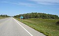
Echo Valley Provincial Park is a provincial park in the Canadian province of Saskatchewan, located west of the town of Fort Qu'Appelle in the Qu'Appelle Valley between Echo Lake and Pasqua Lake in the RM of North Qu'Appelle No. 187. The three main roads to access the park are Highways 210, 56, and 727.

Pasqua Lake is a lake along the course of the Qu'Appelle River in the Canadian province of Saskatchewan. Pasqua Lake was named after Chief Joseph Pasqua who formed what became the Pasqua First Nation. It is one of four lakes that make up the Fishing Lakes, which are all in the Qu'Appelle Valley. The Qu'Appelle Valley was formed about 14,000 years ago during the last ice age as meltwater from the glaciers carved out the valley. As water levels rose and fell, alluvium was left in the wake. These piles of alluvium are what created the separations between the lakes.
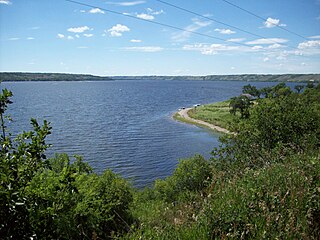
Echo Lake is a lake along the course of the Qu'Appelle River in the Canadian province of Saskatchewan. Echo Lake is so named because of the echo heard by the First Nations while paddling on the lake. It is one of four lakes that make up the Fishing Lakes. Pasqua Lake is upstream and Mission Lake is downstream. The lake can be accessed by Highway 56 and Highway 210.