
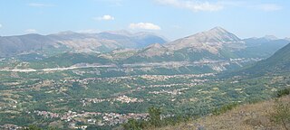
L'Aquila is a city and comune in central Italy. It is the capital city of both the Abruzzo region and of the Province of L'Aquila. As of 2023, it has a population of 69,558 inhabitants. Laid out within medieval walls on a hill in the wide valley of the Aterno river, it is surrounded by the Apennine Mountains, with the Gran Sasso d'Italia to the north-east.
Cascia is a town and comune (municipality) of the Italian province of Perugia in a rather remote area of the mountainous southeastern corner of Umbria. It is about 21 km from Norcia on the road to Rieti in the Lazio (63 km). It is also very close to Terni.
Poggio is an Italian word meaning "knoll". It may refer to:

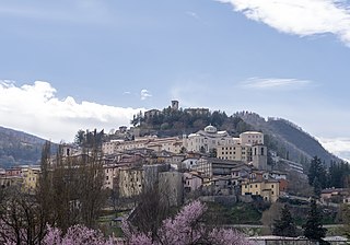
Cappadocia is a comune and town with approximately 550 inhabitants in the province of L'Aquila in the Abruzzo region of central Italy. It is part of Marsica. It's also part of the "Borghi autentici d'Italia" club.

Fossa is a comune and town in the province of L'Aquila in the Abruzzo region of southern Italy. Bernardino of Fossa was born in the town. The 2009 L'Aquila earthquake contributed to the collapse of a bridge in Fossa, and caused extensive damage to the residential buildings in the town. The town was the epicentre of a major aftershock 5.4 Mw on April 7, 2009.

Molina Aterno is a comune and town in the province of L'Aquila in the Abruzzo region of central Italy. The name derives from Latin molina ("mill"), the second part having been added in 1889 due to the presence of the Aterno river.
Pescocostanzo is a comune and town of 1038 inhabitants in the Province of L'Aquila in the Abruzzo region of Italy. It is a tourist destination, attracting people from all over Italy due to its landscape and environment. It is part of the Maiella National Park and is one of I Borghi più belli d'Italia. In winter, Pescocostanzo is a destination for skiers and snowboarders, and has its own ski resort. The towns of Roccaraso and Rivisondoli are close by.
Pratola Peligna is a comune and town in the Province of L'Aquila in the Abruzzo region of Italy. As of 2015, it has a population of 7,652 inhabitants.
Tornimparte is a comune and town in the province of L'Aquila in the Abruzzo region of central-southern Italy.

Crognaleto is a comune and city of slightly less than 2,000 people in the Province of Teramo, central Italy. Crognaleto sits at an elevation of 1,105 metres (3,625 ft) and has its communal administrative offices in the frazione of Nerito. The commune of Crognaleto sits on the slopes of the Monti della Laga mountain range and extends across both the northern and the southern slopes of the Vomano Valley. It lies within the Gran Sasso e Monti della Laga National Park.
Poggio Catino is a comune (municipality) in the Province of Rieti in the Italian region of Latium, located about 45 kilometres (28 mi) northeast of Rome and about 20 kilometres (12 mi) southwest of Rieti. As of 31 December 2011, it had a population of 1,335 and an area of 15.0 square kilometres (5.8 sq mi).

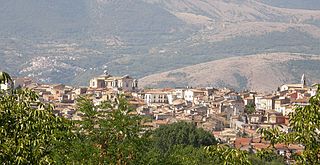
Paganica is a hillside town in the province of L'Aquila, in the Abruzzo region of southern Italy. located at 669 meters above sea level, at the foot of the Gran Sasso d'Italia, about 7 kilometers east of the historic center, along the state road 17 bis that from Bazzano climbs to Campo Imperatore passing for Tempèra, Camarda, Assergi and Fonte Cerreto, with a population of about 5 000 inhabitants, making it the largest fraction of the city, as well as of considerable economic importance. It is a frazione of the comune of L'Aquila, and has a population of about 5,000.

Acciaroli is an Italian hamlet (frazione), the most populous in the comune of Pollica, Province of Salerno, in the Campania Region.
Ioanella is a frazione of the Commune of Torricella Sicura in the Province of Teramo, Italy.
San Gregorio is a village in the Abruzzo region of central Italy. It is a frazione of the comune of L'Aquila. It sits 584 meters above sea level at the base of Monte Manicola. The village of San Gregorio is 12.11 kilometers from the town of L'Aquila, of which it is considered a suburb community. Italy's SS17 Highway is its main transportation artery. The village sits near an active earthquake fault zone in the Valley of the Aterno-Pescara.
Camarda is a frazione in the comune of L'Aquila in the Abruzzo region of Italy. It is situated on the western slopes of the Gran Sasso, at about 800 meters above sea level, along the state road 17-bis that from Bazzano goes up to Campo Imperatore passing through Paganica, Tempera, Assergi and Fonte Cerreto, once an autonomous municipality before being aggregated to the capital and now seat of the ninth district of the municipality.
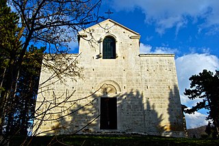
Chiesa di Santa Maria Assunta is a Romanesque church in Bominaco, Province of L'Aquila (Abruzzo).

The Terni–Sulmona railway is a regional railway line in central Italy, managed by Rete Ferroviaria Italiana. It links three regions, Umbria, Lazio and Abruzzo, and three provincial capitals: Terni, Rieti and L'Aquila. Together with the Sulmona–Isernia railway it forms a north–south corridor through the Apennines in central Italy. Its route is the result of two unfinished railways that had to meet in Rieti: the Pescara–L'Aquila–Rome line, and the Terni–Avezzano–Roccasecca line.
On 27 November 1461, a powerful earthquake and series of aftershocks struck Italy's Abruzzo region along the Aterno River. The tremors caused widespread damage to Abruzzo's capital, L'Aquila, and the surrounding villages. At least 80 people are recorded to have died and numerous people were injured by the earthquakes. The quakes also caused major, permanent damage to religious sites and changed politics for L'Aquila and the Abruzzo region.

Lu Bagnu is a hamlet of 1664. inhabitants of the municipality of Castelsardo, in Sassari province.

