Related Research Articles
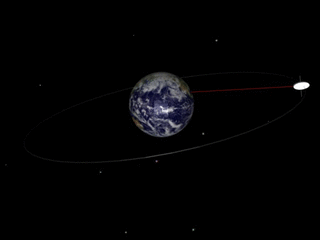
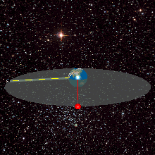
A geosynchronous orbit is an Earth-centered orbit with an orbital period that matches Earth's rotation on its axis, 23 hours, 56 minutes, and 4 seconds. The synchronization of rotation and orbital period means that, for an observer on Earth's surface, an object in geosynchronous orbit returns to exactly the same position in the sky after a period of one sidereal day. Over the course of a day, the object's position in the sky may remain still or trace out a path, typically in a figure-8 form, whose precise characteristics depend on the orbit's inclination and eccentricity. A circular geosynchronous orbit has a constant altitude of 35,786 km (22,236 mi).
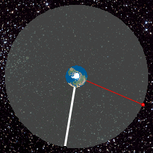
A geostationary orbit, also referred to as a geosynchronous equatorial orbit (GEO), is a circular geosynchronous orbit 35,786 kilometres in altitude above Earth's Equator and following the direction of Earth's rotation.

Milstar is a constellation of military communications satellites in geosynchronous orbit, which are operated by the United States Space Force, and provide secure and jam-resistant worldwide communications to meet the requirements of the Armed Forces of the United States. Six spacecraft were launched between 1994 and 2003, of which five are currently operational; the third launch failed, both damaging the satellite and leaving it in an unusable orbit.
Network performance refers to measures of service quality of a network as seen by the customer.
Thuraya is a United Arab Emirates-based regional mobile-satellite service (MSS) provider. The company operates two geosynchronous satellites and provides telecommunications coverage in more than 161 countries in Europe, the Middle East, North, Central and East Africa, Asia and Australia. Thuraya's L-band network delivers voice and data services.
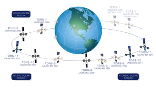
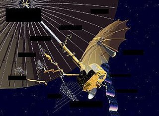
A tracking and data relay satellite (TDRS) is a type of communications satellite that forms part of the Tracking and Data Relay Satellite System (TDRSS) used by NASA and other United States government agencies for communications to and from independent "User Platforms" such as satellites, balloons, aircraft, the International Space Station, and remote bases like the Amundsen-Scott South Pole Station. This system was designed to replace an existing worldwide network of ground stations that had supported all of NASA's crewed flight missions and uncrewed satellites in low-Earth orbits. The primary system design goal was to increase the amount of time that these spacecraft were in communication with the ground and improve the amount of data that could be transferred. These TDRSS satellites are all designed and built to be launched to and function in geosynchronous orbit, 35,786 km (22,236 mi) above the surface of the Earth.
The GPS-aided GEO augmented navigation (GAGAN) is an implementation of a regional satellite-based augmentation system (SBAS) by the Government of India. It is a system to improve the accuracy of a GNSS receiver by providing reference signals. The Airports Authority of India (AAI)'s efforts towards implementation of operational SBAS can be viewed as the first step towards introduction of modern communication, navigation and surveillance / air traffic management system over Indian airspace.
The National Environmental Satellite, Data, and Information Service (NESDIS) was created by the National Oceanic and Atmospheric Administration (NOAA) to operate and manage the United States environmental satellite programs, and manage the data gathered by the National Weather Service and other government agencies and departments.
A geosynchronous satellite is a satellite in geosynchronous orbit, with an orbital period the same as the Earth's rotation period. Such a satellite returns to the same position in the sky after each sidereal day, and over the course of a day traces out a path in the sky that is typically some form of analemma. A special case of geosynchronous satellite is the geostationary satellite, which has a geostationary orbit – a circular geosynchronous orbit directly above the Earth's equator. Another type of geosynchronous orbit used by satellites is the Tundra elliptical orbit.
Orion, also known as Mentor or Advanced Orion, is a class of United States spy satellites that collect signals intelligence (SIGINT) from space. Operated by the National Reconnaissance Office (NRO) and developed with input from the Central Intelligence Agency (CIA), eight have been launched from Cape Canaveral on Titan IV and Delta IV launch vehicles since 1995.
Space Network (SN) is a NASA program that combines space and ground elements to support spacecraft communications in Earth vicinity. The SN Project Office at Goddard Space Flight Center (GSFC) manages the SN, which consists of:

TDRS-B was an American communications satellite, of first generation, which was to have formed part of the Tracking and Data Relay Satellite System. It was destroyed in 1986 when the Space ShuttleChallenger disintegrated 73 seconds after launch.
USA-227, known before launch as NRO Launch 27 (NROL-27), is an American communications satellite which was launched in 2011. It is operated by the United States National Reconnaissance Office.
Kosmos 2473 is a Russian military communications satellite which was launched in 2011 by the Russian Space Forces. It is a Garpun satellite, the new generation of communication relay satellites.

Luch 5B is a Russian Luch relay satellite which will transmit data from the Russian Orbital Segment of the International Space Station, and from other satellites in low Earth orbit. It will be in geosynchronous orbit.
Luch 5A is a Russian Luch relay satellite which will transmit data from the Russian Orbital Segment of the International Space Station, and from other satellites in low Earth orbit. It will be in geosynchronous orbit.

INSAT-3DR is an Indian weather satellite built by the Indian Space Research Organisation and operated by the Indian National Satellite System. It will provide meteorological services to India using a 6-channel imager and a 19-channel sounder, as well as search and rescue information and message relay for terrestrial data collection platforms. The satellite was launched on 8 September 2016, and is a follow-up to INSAT-3D.
HYLAS-4 is a telecommunications satellite owned and operated by Avanti Communications and manufactured by Orbital ATK that was launched by an Ariane 5 rocket on 5 April 2018.

Orbiting Vehicle 2-5, the third and last satellite of the second series of the United States Air Force's Orbiting Vehicle program, was an American particle science and ionosphere research satellite. Launched 26 September 1968 along with three other satellites, OV2-5 became the first scientific satellite to operate at geosynchronous altitude.
References
- ↑ Elbert, Bruce R. (2004). The Satellite Communication Applications Handbook. Artech House. ISBN 978-1580538084 . Retrieved 2014-10-04.