Savi

Last updated
Crowning of the King of Juida (Whydah) in Savi in 1725 Couronnement du roi de Juida-Jacob van der Schley mg 8490.jpg
Crowning of the King of Juida (Whydah) in Savi in 1725
The European factories in Savi AMH-7950-KB Bird's eye view of the European trading posts at Sabi.jpg
The European factories in Savi

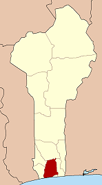
Savi is a town in Benin that was the capital of the Kingdom of Whydah prior to its capture by the forces of Dahomey in 1727.

An account of the city was given by Robert Norris in 1789:

Sabee, at that period the metropolis of the kingdom, the residence of their monarch, and seat of their commerce, was more than four miles in circumference. The houses, constructed with mud walls, were roofed with thatch. The factory houses of the European traders were spacious and airy, distributed into convenient apartments, and surrounded on the outside with a large gallery opening into balconies. The town swarmed with people, insomuch, that it was impossible to pass through the streets without great difficulty. Markets were held every day, at which were exposed to sale all sorts of merchandizes, European and African, besides abundance of provisions of every kind. [1] [2]

There were British, French, Dutch and Portuguese factories in the city, adjacent to the Royal Palace. They were essentially involved in the slave trade.

Related Research Articles

<span class="mw-page-title-main">Dahomey</span> c. 1600 – 1904 kingdom in modern Benin, West Africa

The Kingdom of Dahomey was a West African kingdom located within present-day Benin that existed from approximately 1600 until 1904. Dahomey developed on the Abomey Plateau amongst the Fon people in the early 17th century and became a regional power in the 18th century by expanding south to conquer key cities like Whydah belonging to the Kingdom of Whydah on the Atlantic coast which granted it unhindered access to the tricontinental triangular trade.

<span class="mw-page-title-main">Agaja</span> King of Dahomey from 1718 to 1740

Agaja was a king of the Kingdom of Dahomey, in present-day Benin, who ruled from 1718 until 1740. He came to the throne after his brother King Akaba. During his reign, Dahomey expanded significantly and took control of key trade routes for the Atlantic slave trade by conquering Allada (1724) and Whydah (1727). Wars with the powerful Oyo Empire to the east of Dahomey resulted in Agaja accepting tributary status to that empire and providing yearly gifts. After this, Agaja attempted to control the new territory of the kingdom of Dahomey through militarily suppressing revolts and creating administrative and ceremonial systems. Agaja died in 1740 after another war with the Oyo Empire and his son Tegbessou became the new king. Agaja is credited with creating many of the key government structures of Dahomey, including the Yovogan and the Mehu.

<span class="mw-page-title-main">Tegbesu</span> King of Dahomey from 1740 to 1774

Tegbesu or Bossa Ahadee was a king of the Kingdom of Dahomey, in present-day Benin, from 1740 until 1774. While not the oldest son of King Agaja (1718-1740), he became king after Agaja's death following a succession struggle with a brother.

Kpengla was a King of the Kingdom of Dahomey, in present-day Benin, from 1774 until 1789. Kpengla followed his father Tegbessou to the throne and much of his administration was defined by the increasing Atlantic slave trade and regional rivalry over the profits from this trade. His attempts to control the slave trade generally failed, and when he died of smallpox in 1789, his son Agonglo came to the throne and ended many of his policies.

Agonglo was a King of the Kingdom of Dahomey, in present-day Benin, from 1789 until 1797. Agonglo took over from his father King Kpengla in 1789 and inherited many of the economic problems that developed during Kpengla's reign. Because of the poor economy, Agonglo was often constrained by domestic opposition. As a response, he reformed many of the economic policies and did military expeditions to try to increase the supply for the Atlantic slave trade. Many of these efforts were unsuccessful and European traders became less active in the ports of the kingdom. As a final effort, Agonglo accepted two Portuguese Catholic missionaries which resulted in a large outcry in royal circles and resulted in his assassination on May 1, 1797. Adandozan, his second oldest son, was named the new king.

<span class="mw-page-title-main">Ghezo</span> King of Dahomey from 1818 to 1858

Ghezo, also spelled Gezo, was King of Dahomey from 1818 until 1859. Ghezo replaced his brother Adandozan as king through a coup with the assistance of the Brazilian slave trader Francisco Félix de Sousa. He ruled over the kingdom during a tumultuous period, punctuated by the British blockade of the ports of Dahomey in order to stop the Atlantic slave trade.

<i>Whydah Gally</i> Pirate ship of Samuel "Black Sam" Bellamy

Whydah Gally was a fully rigged galley ship that was originally built as a passenger, cargo, and slave ship. On the return leg of her maiden voyage of the triangle trade, Whydah Gally was captured by the pirate Captain Samuel "Black Sam" Bellamy, beginning a new role in the Golden Age of Piracy.

<span class="mw-page-title-main">Fon people</span> Gbe ethnic group

The Fon people, also called Fon nu, Agadja or Dahomey, are a Gbe ethnic group. They are the largest ethnic group in Benin found particularly in its south region; they are also found in southwest Nigeria and Togo. Their total population is estimated to be about 3,500,000 people, and they speak the Fon language, a member of the Gbe languages.

<span class="mw-page-title-main">Ouidah</span> Commune and city in Atlantique Department, Benin

Ouidah or Whydah and known locally as Glexwe, formerly the chief port of the Kingdom of Whydah, is a city on the coast of the Republic of Benin. The commune covers an area of 364 km2 (141 sq mi) and as of 2002 had a population of 76,555 people.

<span class="mw-page-title-main">Fort of São João Baptista de Ajudá</span> Restored fort in Benin

The Forte de São João Baptista de Ajudá is a small restored fort in Ouidah, Benin. Built in 1721, it was the last of three European forts built in that town to tap the slave trade of the Slave Coast. Following the legal abolition of the slave trade early in the 19th century, the Portuguese fort lay abandoned most of the time until it was permanently reoccupied in 1865.

Akwamu was a state set up by the Akwamu people in present-day Ghana. After migrating from Bono state, the Akan founders of Akwamu settled in Twifo-Heman. The Akwamu led an expansionist empire in the 17th and 18th centuries. At the peak of their empire, Akwamu extended 400 kilometres (250 mi) along the coast from Ouidah, Benin in the East to Winneba, Ghana in the West.

The Kingdom of Whydah ( known locally as; Glexwe / Glehoue, but also known and spelt in old literature as; Hueda, Whidah,Ajuda, Ouidah, Whidaw,Juida, and Juda was a kingdom on the coast of West Africa in what is now Benin. It was a major slave trading area which exported more than one million Africans to the United States and Brazil before closing its trade in the 1860s. In 1700, it had a coastline of around 16 kilometres ; under King Haffon, this was expanded to 64 km, and stretching 40 km inland.

Laurens Prins, anglicized as Lawrence Prince, was a 17th-century Dutch buccaneer, privateer and an officer under Captain Sir Henry Morgan. He and Major John Morris led one of the columns against Panama in 1671.

<span class="mw-page-title-main">Merina Kingdom</span> 1540–1897 kingdom in Madagascar

The Merina Kingdom, or Kingdom of Madagascar, officially the Kingdom of Imerina, was a pre-colonial state off the coast of Southeast Africa that, by the 19th century, dominated most of what is now Madagascar. It spread outward from Imerina, the Central Highlands region primarily inhabited by the Merina ethnic group with a spiritual capital at Ambohimanga and a political capital 24 km (15 mi) west at Antananarivo, currently the seat of government for the modern state of Madagascar. The Merina kings and queens who ruled over greater Madagascar in the 19th century were the descendants of a long line of hereditary Merina royalty originating with Andriamanelo, who is traditionally credited with founding Imerina in 1540.

<span class="mw-page-title-main">Badagry</span> Town in Lagos State, Nigeria

Badagry also spelled Badagri, is a coastal town and Local Government Area (LGA) in Lagos State, Nigeria. It is quite close to the city of Lagos, and located on the north bank of Porto Novo Creek, an inland waterway that connects Lagos to the Beninese capital of Porto-Novo. The same route connects Lagos, Ilaro, and Porto-Novo, and shares a border with the Republic of Benin. As of the preliminary 2006 census results, the municipality had a population of 241,093.

The History of the Kingdom of Dahomey spans 400 years from around 1600 until 1904 with the rise of the Kingdom of Dahomey as a major power on the Atlantic coast of modern-day Benin until French conquest. The kingdom became a major regional power in the 1720s when it conquered the coastal kingdoms of Allada and Whydah. With control over these key coastal cities, Dahomey became a major center in the Atlantic Slave Trade until 1852 when the British imposed a naval blockade to stop the trade. War with the French began in 1892 and the French took over the Kingdom of Dahomey in 1894. The throne was vacated by the French in 1900, but the royal families and key administrative positions of the administration continued to have a large impact in the politics of the French administration and the post-independence Republic of Dahomey, renamed Benin in 1975. Historiography of the kingdom has had a significant impact on work far beyond African history and the history of the kingdom forms the backdrop for a number of novels and plays.

<span class="mw-page-title-main">Panyarring</span>

Panyarring was the practice of seizing and holding persons until the repayment of debt or resolution of a dispute which became a common activity along the Atlantic coast of Africa in the 18th and 19th centuries. The practice developed from pawnship, a common practice in West Africa where members of a family borrowing money would be pledged as collateral to the family providing credit until the repayment of the debt. Panyarring though is different from this practice as it involves the forced seizure of persons when a debt was not repaid.

The Kingdom of Ardra, also known as the Kingdom of Allada, was a coastal West African kingdom in southern Benin. While historically a sovereign kingdom, in present times the monarchy continues to exist as a non-sovereign monarchy within the republic of Benin.

<span class="mw-page-title-main">Role of Nantes in the slave trade</span>

The Nantes slave trade resulted in the deportation, from the late 17th to the beginning of the 19th century, of more than 500,000 black African slaves into French ownership in the Americas, mainly in the Antilles. With 1,744 slave voyages, Nantes, France, was the principal French slave-trading port for the duration of this period. The Slave Trade was explicitly encouraged by the royal family and described by the church as an "ordinary occupation."

The Yoruba Revolutionary Wars, otherwise known as the Yoruba Civil Wars, were a series of conflicts that engulfed the Yoruba-speaking areas of West Africa in the late 18th and early 19th centuries. Robin Law summarizes the causes of the wars as the disintegration of the old Oyo Empire after the death of Alaafin Abiodun in 1789 and a resurgence of long-standing quarrels between the provincial chiefs over various issues. The root of the first disagreements can be traced to the feud between two noble houses; Laderin, based in Ilorin, and Yamba, based in the capital at Oyo-Ile. The conflict was also exacerbated by a Muslim slave rebellion led by a Fulani Muslim cleric, Shehu Alimi, and sponsored by the Aare Ona Kakanfo, Afonja, a descendant of Laderin, the founder of Ilorin, in 1817.

References

  1. Monroe, Cameron. "Urbanism on West Africa's Slave Coast". American Scientist. Archived from the original on 13 January 2014. Retrieved 24 September 2014.
  2. Norris, Robert (1789). "Memoirs of the Reign of Bossa Ahádee: King of Dahomy, an Inland Country of Guiney. To which are Added, the Author's Journey to Abomey, the Capital; and a Short Account of the African Slave Trade. By Robert Norris. Illustrated with a New Map".

Coordinates: 6°25′N2°06′E / 6.417°N 2.100°E / 6.417; 2.100