The history of Trinidad and Tobago begins with the settlements of the islands by Indigenous First Peoples. Trinidad was visited by Christopher Columbus on his third voyage in 1498,, and claimed in the name of Spain. Trinidad was administered by Spanish hands until 1797, but it was largely settled by French colonists. Tobago changed hands between the British, French, Dutch, and Courlanders, but eventually ended up in British hands following the second Treaty of Paris (1814). In 1889, the two islands were incorporated into a single political entity. Trinidad and Tobago obtained its independence from the British Empire in 1962 and became a republic in 1976.
Trinidad and Tobago, a country that relies heavily on industrialisation and tourism, has various transport systems.

The Trinidad and Tobago Defence Force (TTDF) is the military organisation responsible for the defence of the twin island Republic of Trinidad and Tobago. It consists of the Trinidad and Tobago Regiment, the Trinidad and Tobago Coast Guard, the Trinidad and Tobago Air Guard and the Defence Force Reserves.

Port of Spain, officially the City of Port of Spain, is the capital of Trinidad and Tobago and the third largest municipality, after Chaguanas and San Fernando. The city has a municipal population of 37,074 (2011), an urban population of 81,142 and a transient daily population of 250,000. It is located on the Gulf of Paria, on the northwest coast of the island of Trinidad and is part of a larger conurbation stretching from Chaguaramas in the west to Arima in the east with an estimated population of 600,000.
Tobago is an island and ward within the Republic of Trinidad and Tobago. It is located 35 kilometres (22 mi) northeast of the larger island of Trinidad and about 160 kilometres (99 mi) off the northeastern coast of Venezuela. It lies to the southeast of Grenada.

San Fernando, officially the City of San Fernando, is the most populous city and second most populous municipality in Trinidad and Tobago, after Chaguanas. Sando, as it is known to many local Trinidadians, occupies 19 km2 and is located in the southwestern part of the island of Trinidad. It is bounded to the north by the Guaracara River, the south by the Oropouche River, the east by the Sir Solomon Hochoy Highway, and the west by the Gulf of Paria. The former borough was elevated to the status of a city corporation on 18 November 1988. The motto of San Fernando is: "Sanitas Fortis" - In a Healthy Environment We Will Find Strength. San Fernando is called Trinidad and Tobago's "industrial capital" because of its proximity to the Pointe-à-Pierre oil refinery and many other petrochemical, LNG, iron and steel and aluminium smelters in places such as Point Lisas in Couva, Point Fortin, and La Brea.

The Borough of Chaguanas is the largest municipality and fastest-growing town in Trinidad and Tobago. Located in west-central Trinidad, south of Port of Spain, north of Couva and San Fernando, and named after the indigenous tribe who originally settled there, it grew in size due to its proximity to the Woodford Lodge sugar refinery. It remained a minor town until the 1980s when it began to grow rapidly as it drew people for its bargain shopping and moderately priced housing. Its rapid growth has seen property values increase dramatically, however.

Arima, officially The Royal Chartered Borough of Arima is the easternmost and second largest in area of the three boroughs of Trinidad and Tobago. It is geographically adjacent to Sangre Grande and Arouca at the south central foothills of the Northern Range. To the south is the Caroni–Arena Dam. Coterminous with Town of Arima since 1888, the borough of Arima is the fourth-largest municipality in population in the country. The census estimated it had 33,606 residents in 2011.
Princes Town is a town within an eponymous region, located on south-Central Trinidad island in Trinidad and Tobago. The population of the town is 28,335.
Couva is an urban town in west-central Trinidad, south of Port of Spain and Chaguanas and north of San Fernando and Point Fortin. It is the capital and main urban centre of Couva–Tabaquite–Talparo, and the Greater Couva area includes the Point Lisas industrial estate and the port of Point Lisas. It is one of the fastest-growing towns in the country. Couva's southern boundary is at the village of California and Point Lisas, and to the north Couva stretches to McBean. To the east of Couva is Preysal. To the west of Couva is the road to Waterloo and Carli Bay, which are located on the Gulf of Paria. Couva was part of the Caroni County. Couva is considered a major power base for the United National Congress, whose headquarters was previously located here.

San Juan is a town in Trinidad and Tobago. Located in San Juan–Laventille region in Saint George County, it lies within the East-West Corridor Metropolitan Area, between Laventille and Saint Joseph.

Diego Martin is a town and is the urban commercial center and capital of the Diego Martin region in Trinidad and Tobago. Its location in the region is just on the south eastern border, west of the capital city of Port of Spain and east of the town of Carenage. Diego Martin town in the Northern Range was once filled with a number of small valleys but is now a densely populated area. It was named after a Spanish explorer Don Diego Martín. The area was settled by French planters and their slaves in the 1780s. It consists of a cluster of communities including Congo Village, Diamond Vale, Green Hill, Patna Village, Petit Valley, Blue Range, La Puerta Avenue, Four Roads, Rich Plain, River Estate, Blue Basin, Water Wheel, West Moorings, Bagatelle and Sierra Leone.
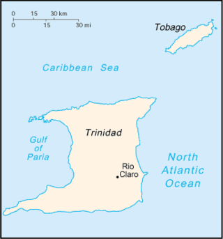
Rio Claro is the largest town in southeastern Trinidad, in Trinidad and Tobago. Rio Claro lies east of Princes Town, west of Mayaro and northwest of Guayaguayare. It serves as the major commercial centre for southeastern Trinidad. It lies in a primarily agricultural area. It is the seat of the Region of Mayaro–Rio Claro.

A. N. R. Robinson International Airport is an international airport located in Crown Point, Tobago in Trinidad and Tobago. It is located in the southwesternmost part of the island, near the town of Bon Accord, and 11 km (6.8 mi) from the capital, Scarborough. The airport is one of two international airports serving the twin isle republic of Trinidad and Tobago. The other airport is located on the island of Trinidad, Piarco International Airport.

Saint George is a county in Trinidad and Tobago. It occupies the northwestern portion of the island of Trinidad and is bounded by the Caribbean Sea to the north, the Gulf of Paria to the west, Caroni County to the south and Saint David County and Saint Andrew County to the east. It occupies an area of 912 km2 (352 sq mi). The county includes the Bocas Islands and the towns of Port of Spain and Arima. It also includes the small town of Blanchisseuse and its attractive beach, backed by a forest-fringed lagoon. County Saint George is divided into six Wards: Diego Martin, Saint Ann's, Blanchisseuse, Tacarigua, Arima and San Raphael.

Piarco International Airport is an international airport serving the island of Trinidad and is one of two international airports in Trinidad and Tobago. The airport is located 30 km (19 mi) east of Downtown Port of Spain, located in the suburban town of Piarco. The airport is the primary hub and operating base for the country's national airline, as well as the Caribbean's largest airline, Caribbean Airlines.

Trinidad and Tobago, officially the Republic of Trinidad and Tobago, is the southernmost island country in the Caribbean. Consisting of the main islands Trinidad and Tobago and numerous much smaller islands, it is situated 11 kilometres off the coast of northeastern Venezuela and 130 kilometres south of Grenada. It shares maritime boundaries with Barbados to the east, Grenada to the northwest and Venezuela to the south and west. Trinidad and Tobago is generally considered to be part of the West Indies. The island country's capital is Port of Spain, while its largest and most populous municipality is Chaguanas.
Trinidad and Tobago operates under a two-tier healthcare system. That is, there is the existence of both private and public facilities.

The history of Tobago covers a period from the earliest human settlements on the island of Tobago in the Archaic period, through its current status as a part of the Republic of Trinidad and Tobago. Originally settled by indigenous people, the island was subject to Spanish slave raids in the sixteenth and early seventeenth century and colonisation attempts by the Dutch, British, French, and Courlanders beginning in 1628, though most colonies failed due to indigenous resistance. After 1763 Tobago was converted to a plantation economy by British settlers and enslaved Africans.


